- Mount Sugarloaf (New South Wales)
-
Mount Sugarloaf 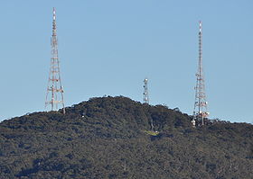
Mount Sugarloaf viewed from West WallsendElevation 412 m (1,352 ft) Parent peak None Location West Wallsend, NSW Australia
 Mount Sugarloaf
Range Sugarloaf Range Coordinates 32°52′54″S 151°32′4″E / 32.88167°S 151.53444°ECoordinates: 32°52′54″S 151°32′4″E / 32.88167°S 151.53444°E[1][2] Topo map NEWCASTLE 9232,
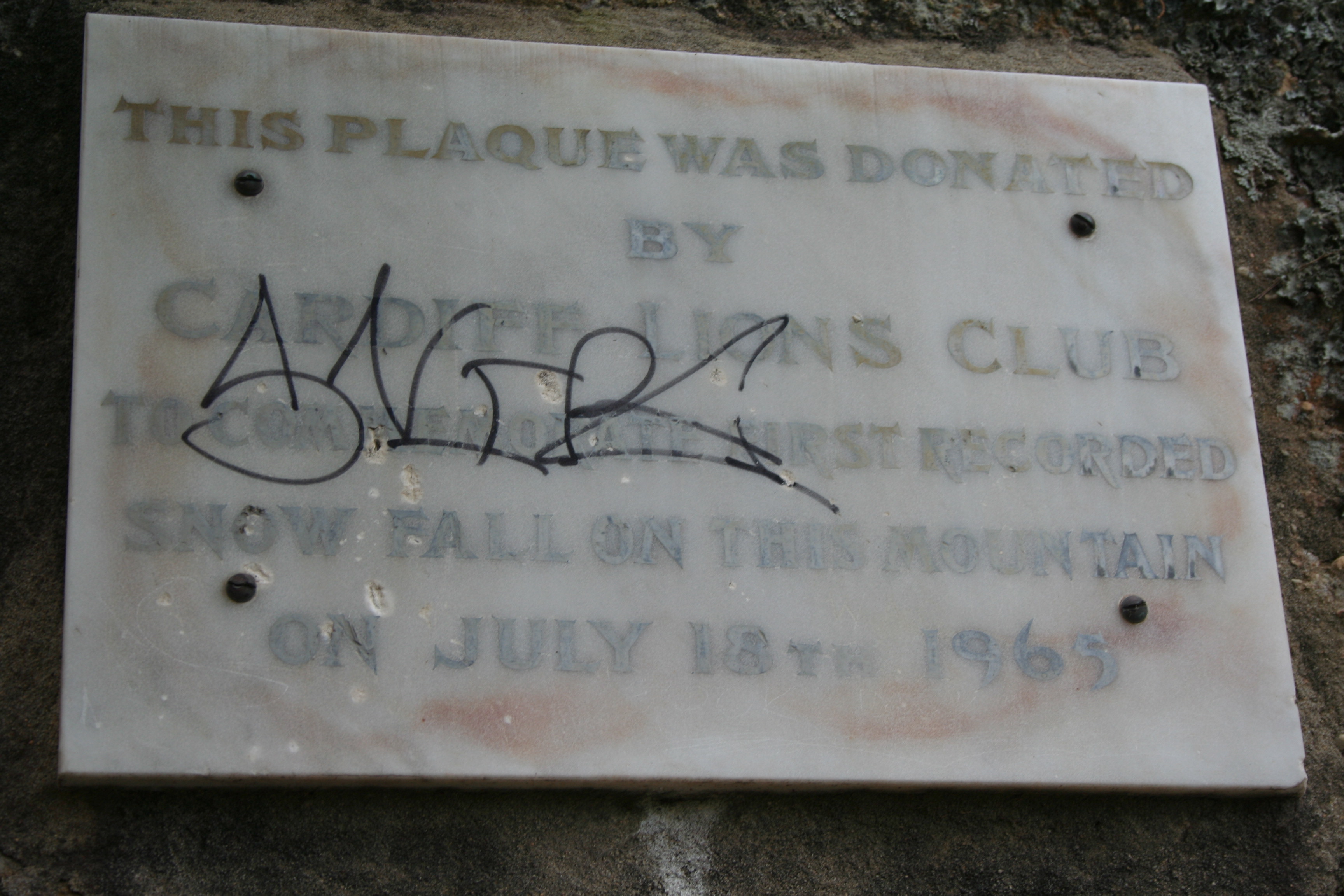
WALLSEND 92323SClimbing Easiest route Road to carpark at 370 m (1,214 ft), walking track to summit Mount Sugarloaf, also known as Great Sugar Loaf, is a mountain in the lower Hunter Region of New South Wales, Australia, overlooking the cites of Newcastle, Lake Macquarie, Cessnock and Maitland.[1][2] The summit of the mountain is in the Lake Macquarie suburb of West Wallsend and access to the summit is gained via this suburb. However, the mountain itself is also part of the city of Cessnock suburbs Mulbring and Richmond Vale.[3] It is home to television transmitters that broadcast to the lower Hunter region. On 18 and 19 July 1965, the mountain received 10 centimetres (4 in) of snow. It also snowed on the summit in the winter of 1975.
Contents
Television transmitters
The mountain has two broadcast transmission towers. One transmitting the VHF television services of NBN Television on VHF Channel 3, as well as local FM radio station New FM. It is commonly referred to as the "NBN Tower". Another transmitting digital and analogue television signals of ABHN-5A (ABC) on VHF Channel 5A, UHF stations SBS, Southern Cross Ten and Prime Television. As well other local commercial radio services. It is controlled by Broadcast Australia, being formerly run by the National Transmission Authority. There are many lesser radio antennae on these towers.
Smaller tower
There is a third smaller tower that has many directional antennae, mainly used for point to point connections, such as two way radio for emergency services and other similar.
Gallery
-
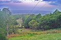
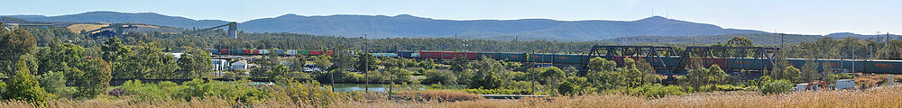
Looking toward Newcastle from the Mount Sugarloaf carpark
-
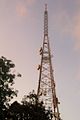
Transmission Tower at Mount Sugarloaf
-

Plaque commemorating the first recorded snowfall on the mountain in 1965
References
- ^ a b "Geographical Names Register Extract: Mount Sugarloaf". Geographical Names Register (GNR) of NSW. Geographical Names Board of New South Wales. http://www.gnb.nsw.gov.au/name_search/extract?id=anwGZxWAan. Retrieved 25 August 2010.
- ^ a b "Geographical Names Register Extract: Great Sugar Loaf". Geographical Names Register (GNR) of NSW. Geographical Names Board of New South Wales. http://www.gnb.nsw.gov.au/name_search/extract?id=MawGBKrXSX. Retrieved 25 August 2010.
- ^ "West Wallsend". Land and Property Management Authority - Spatial Information eXchange. New South Wales Land and Property Management Authority. http://imagery.maps.nsw.gov.au/?role=mysuburb&search=suburb&suburb=West%20Wallsend. Retrieved 7 September 2010.
External links
Towns, suburbs and localities of the City of Cessnock | Hunter Region | New South Wales Towns, suburbs
& localitiesAberdare • Aberdare West • Abermain • Abernethy • Allandale • Anvil Creek • Bellbird • Bellbird Heights • Big Yengo • Bishops Bridge • Black Hill • Blaxlands Arm • Boree • Branxton • Brunkerville • Buchanan • Buttai • Campbell • Cedar Creek • Central Wattagan • Cessnock • Cessnock North • Cessnock South • Cessnock West • Cliftleigh • Congewai • Crawfordville • East Branxton • East Cessnock • Eglinford • Ellalong • Elrington • Greta • Greta Main • Heaton • Heddon Greta • Kearsley • Keinbah • Kitchener • Kurri Kurri • Kurri Kurri North • Kurri Kurri West • Laguna • Little Wallabadah • Lovedale • Loxford • Millfield • Mootai • Moruben • Mount View • Mount Vincent • Mulbring • Murrays Run • Narone Creek • Neath • North Rothbury • Nulkaba • Paxton • Paynes Crossing • Pelaw Main • Pelton • Pokolbin • Quorrobolong • Richmond Main • Richmond Vale • Rothbury • Sawyers Gully • South Weston • Spion Kop • Stanford Merthyr • Stockrington • Sweetmans Creek • Tomalpin • Watagan • Watagan Central • Watagan Forest • Weston • Wollombi • Yallambie • Yango • Yango Creek
Other places &
points of interestCessnock Airport • Hunter Valley Railway Trust • Huntlee (proposed town) • Mount Sugarloaf • Richmond Vale Railway • Watagans National Park • Werakata National Park
Towns, suburbs and localities of the City of Newcastle | Hunter Region | New South Wales Towns, suburbs
& localitiesAdamstown · Adamstown Heights · Bar Beach · Beresfield · Birmingham Gardens · Black Hill · Broadmeadow · Callaghan · Carrington · Cooks Hill · Elermore Vale · Fletcher · Georgetown · Hamilton · Hamilton East · Hamilton North · Hamilton South · Hexham · The Hill · Islington · Jesmond · The Junction · Kooragang · Kotara · Lambton · Lenaghan · Maryland · Maryville · Mayfield · Mayfield East · Mayfield North · Mayfield West · Merewether · Merewether Heights · Minmi · New Lambton · New Lambton Heights · Newcastle · Newcastle East · Newcastle West · North Lambton · Rankin Park · Sandgate · Shortland · Stockton · Tarro · Tighes Hill · Wallsend · Warabrook · Waratah · Waratah West · Wickham
Other places &
points of interestBroadmeadow Basketball Stadium • Christ Church Cathedral • Fernleigh Track • Fort Scratchley • Glenrock Lagoon • Hunter River • Hunter Street • John Hunter Hospital • Kooragang Island • Mount Sugarloaf • National Stock Exchange of Australia • Newcastle Civic Theatre • Newcastle Entertainment Centre • Newcastle International Sports Centre • Nobbys Head • Royal Newcastle Hospital • State Dockyard • Stockton Beach • University of Newcastle • Victoria Theatre
Significant places and items of interest in the Hunter Region of New South Wales Commerce and industry IndustryDarley Stud • Hunter Valley Coal Chain • Hunter Valley wine • Kia-Ora stud • Kooragang Island • Newcastle Port Corporation • Tomago aluminium smelterShoppingOtherEducation PrimarySecondaryAll Saints College, St Joseph's Campus • Avondale School • Hunter School of the Performing Arts • Hunter Valley Grammar School • Irrawang High School • Lambton High School • Maitland Grossmann High School • Maitland High School • Merewether High School • Newcastle Grammar School • Newcastle High School • Rutherford Technology High School • Tomaree High SchoolTertiaryEntertainment, sport & culture Broadmeadow Basketball Stadium • Dungog Film Festival • Hunter Valley Steamfest • Newcastle Civic Theatre • Newcastle Entertainment Centre • Newcastle International Sports Centre • Newcastle Number 1 Sports Ground • Newcastle Regional ShowGeography GeneralBroughton Island • Burning Mountain • Cape Hawke • Glenrock Lagoon • Lake Macquarie • Myall Lakes • Mount Royal Range • Mount Sugarloaf • Port Stephens • Stockton Beach • Tops to Myall Heritage TrailNational parksBarrington Tops National Park • Black Bulga State Conservation Area • Booti Booti National Park • Ghin-Doo-Ee National Park • Mount Royal National Park • Myall Lakes National Park • Tomaree National Park • Towarri National Park • Wallingat National Park • Watagans National Park • Werakata National ParkRiversAvon River • Barrington River • Chichester River • Gloucester River • Goulburn River • Hunter River • Karuah River • Manning River • Myall River • Pages River • Paterson River • Williams RiverHistorical Air transportDefenceEducationGeneralHistory of Newcastle, New South Wales • Hunter Valley cannabis infestation • Lake Macquarie Petrified Forest • Maitland Gaol • Nobbys Head • Royal Newcastle Hospital • Tahlee historic propertyIndustryCockle Creek Power Station • Cockle Creek Smelter • South Maitland coalfields • South Waratah Colliery • State Dockyard • Teralba Colliery • Walka Water Works • Wangi Power StationMaritimeNatural disasters1989 Newcastle earthquake • June 2007 Hunter Region and Central Coast storms • Seaham bushfires (1939)PeopleRailGeneralHunter Valley Railway Trust • Hunter Valley Steamfest • Murulla rail accidentRailway linesBelmont railway line • East Maitland – Morpeth railway line • Fernleigh Track • Richmond Vale Railway • South Maitland Railway • Toronto railway lineRailway stationsTramsWine makingWorld War IINo. 2 Fighter Sector RAAF • No. 208 Radar Station RAAF • HMAS Assault • Belmont Anti-Tank Ditch • Lake Macquarie anti-submarine boom • Newcastle Covering Force • RAAF Base Rathmines • Shelling of NewcastleInfrastructure TransportRoadBus routes in Newcastle, New South Wales • Bucketts Way • Golden Highway • Hunter Expressway • New England Highway • Newcastle Inner City Bypass • Pacific Highway • Putty Road • Sydney-Newcastle Freeway • Tea Gardens-Hawks Nest Bridge • Thunderbolts WayRailway linesHunter • Main North • Newcastle and Central CoastRailway stationsAberdeen • Adamstown • Awaba • Beresfield • Booragul • Branxton • Broadmeadow • Cardiff • Civic • Cockle Creek • Dora Creek • Dungog • East Maitland • Fassifern • Glendale • Greta • Hamilton • Hexham • High Street • Hilldale • Kotara • Lochinvar • Maitland • Martins Creek • Metford • Mindaribba • Morisset • Muswellbrook • Newcastle • Paterson • Sandgate • Scone • Singleton • Tarro • Telarah • Teralba • Thornton • Victoria Street • Wallarobba • Warabrook • Waratah • Wickham • Wirragulla • WyeeAirUtilitiesElectricity generationBayswater Power Station • Eraring Power Station • Lake Liddell • Liddell Power Station • Redbank Power Station • Teralba Colliery • Vales Point Power StationWater supplyMedia Other DefenceGeneralHospitalsCategories:- Newcastle, New South Wales
- Lake Macquarie
- Mountains of New South Wales
- Lake Macquarie geography stubs
-


Wikimedia Foundation. 2010.