- Mulbring, New South Wales
-
 Mulbring, NSW
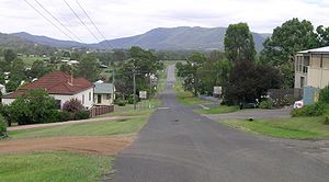
Mulbring is a village in the Hunter Region of New South Wales, Australia. In 2006 Mulbring had a population of 316, which included part of Mount Vincent.[1]
The village is situated about 10 kilometres south of Kurri Kurri and about 1 km north of the village of Mount Vincent. The nearest major town is Cessnock which is approximately 25 km north-west of Mulbring. Mulbring is in the City of Cessnock Local Government Area (LGA) and Northumberland County at an elevation of 47 metres above sea level.[2]
Mulbring was originally a stopping place for travellers going to and from Sydney to the Maitland and Newcastle area in the late 19th century.
It is serviced with a post office and public school which has about 93 pupils enrolled.[3]
See also
References
- ^ Australian Bureau of Statistics (25 October 2007). "Mulbring (State Suburb)". 2006 Census QuickStats. http://www.censusdata.abs.gov.au/ABSNavigation/prenav/LocationSearch?collection=Census&period=2006&areacode=UCL156200&producttype=QuickStats&breadcrumb=PL&action=401. Retrieved 2010-04-18.
- ^ Geographical Names Register extract Retrieved 2010-4-18
- ^ NSW public schools Retrieved 2010-4-19
- ^ "Mulbring". Land and Property Management Authority - Spatial Information eXchange. New South Wales Land and Property Management Authority. http://imagery.maps.nsw.gov.au/?role=mysuburb&search=suburb&suburb=Mulbring. Retrieved 7 September 2010.
External links
Coordinates: 32°54′24″S 151°29′34″E / 32.90667°S 151.49278°E
Towns, suburbs and localities of the City of Cessnock | Hunter Region | New South Wales Towns, suburbs
& localitiesAberdare • Aberdare West • Abermain • Abernethy • Allandale • Anvil Creek • Bellbird • Bellbird Heights • Big Yengo • Bishops Bridge • Black Hill • Blaxlands Arm • Boree • Branxton • Brunkerville • Buchanan • Buttai • Campbell • Cedar Creek • Central Wattagan • Cessnock • Cessnock North • Cessnock South • Cessnock West • Cliftleigh • Congewai • Crawfordville • East Branxton • East Cessnock • Eglinford • Ellalong • Elrington • Greta • Greta Main • Heaton • Heddon Greta • Kearsley • Keinbah • Kitchener • Kurri Kurri • Kurri Kurri North • Kurri Kurri West • Laguna • Little Wallabadah • Lovedale • Loxford • Millfield • Mootai • Moruben • Mount View • Mount Vincent • Mulbring • Murrays Run • Narone Creek • Neath • North Rothbury • Nulkaba • Paxton • Paynes Crossing • Pelaw Main • Pelton • Pokolbin • Quorrobolong • Richmond Main • Richmond Vale • Rothbury • Sawyers Gully • South Weston • Spion Kop • Stanford Merthyr • Stockrington • Sweetmans Creek • Tomalpin • Watagan • Watagan Central • Watagan Forest • Weston • Wollombi • Yallambie • Yango • Yango Creek
Other places &
points of interestCessnock Airport • Hunter Valley Railway Trust • Huntlee (proposed town) • Mount Sugarloaf • Richmond Vale Railway • Watagans National Park • Werakata National Park
Categories:- Localities in New South Wales
- Hunter region geography stubs

Wikimedia Foundation. 2010.