- Combaning, New South Wales
-
Combaning
New South Wales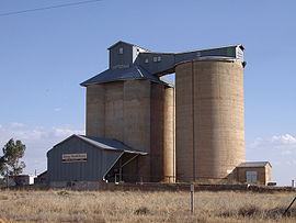
Silos at Combaning
 Combaning
Population: 214[1] Postcode: 2666 Coordinates: 34°27′31″S 147°40′56″E / 34.45861°S 147.68222°ECoordinates: 34°27′31″S 147°40′56″E / 34.45861°S 147.68222°E Elevation: 303 m (994 ft) Location: - 409 km (254 mi) from Sydney
- 98 km (61 mi) from Wagga Wagga
- 13 km (8 mi) from Temora
- 3 km (2 mi) from Springdale [2]
LGA: Temora Shire County: Bland State District: Murrumbidgee Combaning is a rural community in the north east part of the Riverina. It is situated by road, about 3 kilometres west from Springdale and 13 kilometres east from Temora. At the 2006 census, Combaning had a population of 214 people.[1]
The place name Combaning is derived from the local Aboriginal word meaning 'to hold water'.[3]
Combaning railway station
A railway station on the branch line to Lake Cargelligo served the community between 1893 and 1975.[4]
Preceding station NSW Branch lines Following station Temoratowards Lake CargelligoLake Cargelligo Line towards CootamundraNotes and references
- ^ a b Australian Bureau of Statistics (25 October 2007). "Combaning (State Suburb)". 2006 Census QuickStats. http://www.censusdata.abs.gov.au/ABSNavigation/prenav/LocationSearch?collection=Census&period=2006&areacode=SSC16761&producttype=QuickStats&breadcrumb=PL&action=401. Retrieved 12 July 2009.
- ^ Travelmate
- ^ NSW Geographical Names Board
- ^ Combaning station. NSWrail.net, accessed 6 September 2009.
Categories:- Towns in New South Wales
- Towns in the Riverina
- Australian Aboriginal placenames


Wikimedia Foundation. 2010.