- Mitta Mitta, New South Wales
-
This article is about the locality in New South Wales, Australia. For the town in Victoria, Australia, see Mitta Mitta, Victoria.
Mitta Mitta
New South Wales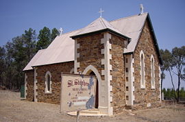
St Stephen's Anglican Church
 Mitta Mitta
Population: 151 (2006 Census)[1] Coordinates: 34°53′S 147°51′E / 34.883°S 147.85°ECoordinates: 34°53′S 147°51′E / 34.883°S 147.85°E Elevation: 303 m (994 ft) Location: LGA: Junee Shire County: Clarendon State District: Burrinjuck Mitta Mitta is a farming community in the north eastern part of the Riverina. It is situated by road, about 30 kilometres south from Bethungra and 21 kilometres north east from Nangus. At the 2006 census, Mitta Mitta had a population of 151 people.[1]
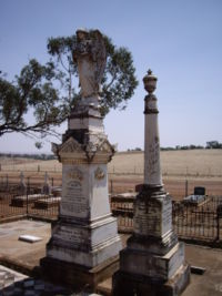 Mitta Mitta Cemetery
Mitta Mitta is locatable only by finding the old St Stephen's Anglican Church situated 8 kilometres along a corrugated dirt road that runs west from the Nangus to Bethungra road.
The place name Mitta Mitta is derived from the local Aboriginal word meaning "Little Waters".[2]
Mitta Mitta Post Office opened on 1 January 1888, was reduced to a Telephone Office in 1931 and closed in 1936.[3]
References and notes
- ^ a b Australian Bureau of Statistics (25 October 2007). "Mitta Mitta (State Suburb)". 2006 Census QuickStats. http://www.censusdata.abs.gov.au/ABSNavigation/prenav/LocationSearch?collection=Census&period=2006&areacode=SSC26187&producttype=QuickStats&breadcrumb=PL&action=401. Retrieved 30 October 2009.
- ^ NSW Geographical Names Board
- ^ Premier Postal History, Post Office List, https://www.premierpostal.com/cgi-bin/wsProd.sh/Viewpocdwrapper.p?SortBy=NSW&country=, retrieved 2009-06-11
Categories:- Towns in New South Wales
- Towns in the Riverina
- Double-named places in Australia


Wikimedia Foundation. 2010.