Mitchell County, New South Wales
- Mitchell County, New South Wales
-
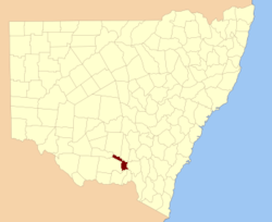
Mitchell County is one of the 141 Cadastral divisions of New South Wales. It contains the town of Collingullie. The Murrumbidgee River is the northern boundary.
Mitchell County is named in honour of the Surveyor-General Sir Thomas Livingstone Mitchell (1792-1855).[1]
Parishes within this county
A full list of parishes found within this county; their current LGA and mapping coordinates to the approximate centre of each location is as follows:
References
- ^ Geographical Names Board of NSW
Categories:
- Counties of New South Wales
Wikimedia Foundation.
2010.
Look at other dictionaries:
Urana County, New South Wales — Infobox Australian cadastral name = Urana state = New South Wales caption = Location in New South Wales near nw = Boyd near n = Boyd near ne = Mitchell near e = Mitchell near se = Hume near s = Denison near sw = Townsend near w = TownsendUrana… … Wikipedia
Bourke County, New South Wales — Infobox Australian cadastral name = Bourke state = New South Wales caption = Location in New South Wales near nw = Dowling near n = Gipps near ne = Bland near e = Clarendon near se = Wynyard near s = Mitchell near sw = Mitchell near w =… … Wikipedia
Townsend County, New South Wales — Infobox Australian cadastral name = Townsend state = New South Wales caption = Location in New South Wales near nw = Waradgery near n = Waradgery near ne = Boyd near e = Urana near se = Denison near s = Moira (Vic) near sw = Cadell near w =… … Wikipedia
Wynyard County, New South Wales — Infobox Australian cadastral name = Wynyard state = New South Wales caption = Location in New South Wales near nw = Bourke near n = Clarendon near ne = Harden near e = Buccleuch near se = Selwyn near s = Selwyn near sw = Goulburn near w =… … Wikipedia
Goulburn County, New South Wales — Infobox Australian cadastral name = Goulburn state = New South Wales caption = Location in New South Wales near nw = Mitchell near n = Wynyard near ne = Wynyard near e = Selwyn near se = Selwyn near s = Benambra (Vic) near sw = Bogong (Vic) near… … Wikipedia
Cooper County, New South Wales — Map of all coordinates from Google Map of all coordinates from Bing Export all coordinates as KML … Wikipedia
Clarke County, New South Wales — Map of all coordinates from Google Map of all coordinates from Bing Export all coordinates as KML … Wikipedia
Clarendon County, New South Wales — Map of all coordinates from Google Map of all coordinates from Bing Export all coordinates as KML … Wikipedia
Hume County, New South Wales — Infobox Australian cadastral name = Hume state = New South Wales caption = Location in New South Wales near nw = Urana near n = Urana near ne = Mitchell near e = Goulburn near se = Benambra (Vic) near s = Bogong (Vic) near sw = Moira (Vic) near w … Wikipedia
New England (New South Wales) — New England New South Wales Mount Duval in New England Population … Wikipedia