Cadell County

Cadell County
Cadell
New South Wales
Cadell NSW.PNG
Location in New South Wales
Lands administrative divisions around Cadell
Wakool Townsend Townsend
Wakool Cadell Townsend
Gunbower (Vic) Rodney (Vic) Moira (Vic)

Cadell County is one of the 141 Cadastral divisions of New South Wales. It contains the city of Moama.

Cadell County was named in honour of Francis Cadell (1822-1879), river navigator and entrepreneur.[1]

Parishes within this county

A full list of parishes found within this county; their current LGA and mapping coordinates to the approximate centre of each location is as follows:

Parish LGA Coordinates
Bama Murray Shire Council 36°00′54″S 144°51′04″E / 36.015°S 144.85111°E / -36.015; 144.85111 (Bama)
Benarca Murray Shire Council 35°57′54″S 144°38′04″E / 35.965°S 144.63444°E / -35.965; 144.63444 (Benarca)
Bunnaloo Murray Shire Council 35°45′54″S 144°41′04″E / 35.765°S 144.68444°E / -35.765; 144.68444 (Bunnaloo)
Burrumbury Murray Shire Council 35°49′54″S 144°25′04″E / 35.83167°S 144.41778°E / -35.83167; 144.41778 (Burrumbury)
Caldwell Murray Shire Council 35°39′54″S 144°28′04″E / 35.665°S 144.46778°E / -35.665; 144.46778 (Caldwell)
Caloola Murray Shire Council 36°00′54″S 144°44′04″E / 36.015°S 144.73444°E / -36.015; 144.73444 (Caloola)
Caloola Murray Shire Council 35°59′54″S 144°43′04″E / 35.99833°S 144.71778°E / -35.99833; 144.71778 (Caloola)
Gotha Murray Shire Council 35°37′54″S 144°35′04″E / 35.63167°S 144.58444°E / -35.63167; 144.58444 (Gotha)
Gothog Murray Shire Council 35°40′54″S 144°41′04″E / 35.68167°S 144.68444°E / -35.68167; 144.68444 (Gothog)
Gulpa Murray Shire Council 35°50′54″S 144°51′04″E / 35.84833°S 144.85111°E / -35.84833; 144.85111 (Gulpa)
Marah Murray Shire Council 35°33′54″S 144°29′04″E / 35.565°S 144.48444°E / -35.565; 144.48444 (Marah)
Mars Murray Shire Council 35°53′54″S 144°39′04″E / 35.89833°S 144.65111°E / -35.89833; 144.65111 (Mars)
Mathoura Murray Shire Council 35°45′54″S 144°46′04″E / 35.765°S 144.76778°E / -35.765; 144.76778 (Mathoura)
Moama Murray Shire Council 36°03′54″S 144°48′04″E / 36.065°S 144.80111°E / -36.065; 144.80111 (Moama)
Moira Murray Shire Council 35°55′54″S 144°49′04″E / 35.93167°S 144.81778°E / -35.93167; 144.81778 (Moira)
Nallam Murray Shire Council 35°49′54″S 144°46′04″E / 35.83167°S 144.76778°E / -35.83167; 144.76778 (Nallam)
Perricoota Murray Shire Council 35°57′54″S 144°33′04″E / 35.965°S 144.55111°E / -35.965; 144.55111 (Perricoota)
Porthole Murray Shire Council 35°35′54″S 144°21′04″E / 35.59833°S 144.35111°E / -35.59833; 144.35111 (Porthole)
Tamar Murray Shire Council 35°48′54″S 144°34′04″E / 35.815°S 144.56778°E / -35.815; 144.56778 (Tamar)
Tantonan Murray Shire Council 35°42′54″S 144°23′04″E / 35.715°S 144.38444°E / -35.715; 144.38444 (Tantonan)
Tataila Murray Shire Council 36°02′54″S 144°42′04″E / 36.04833°S 144.70111°E / -36.04833; 144.70111 (Tataila)
Thule Murray Shire Council 35°37′54″S 144°24′04″E / 35.63167°S 144.40111°E / -35.63167; 144.40111 (Thule)
Thyra Murray Shire Council 35°49′54″S 144°41′04″E / 35.83167°S 144.68444°E / -35.83167; 144.68444 (Thyra)
Tomara Murray Shire Council 35°49′54″S 144°28′04″E / 35.83167°S 144.46778°E / -35.83167; 144.46778 (Tomara)
Toorangabby Murray Shire Council 35°54′54″S 144°28′04″E / 35.915°S 144.46778°E / -35.915; 144.46778 (Toorangabby)
Wirringan Murray Shire Council 35°40′54″S 144°35′04″E / 35.68167°S 144.58444°E / -35.68167; 144.58444 (Wirringan)
Womboota Murray Shire Council 35°53′54″S 144°33′04″E / 35.89833°S 144.55111°E / -35.89833; 144.55111 (Womboota)
Wongal Murray Shire Council 35°44′54″S 144°35′04″E / 35.74833°S 144.58444°E / -35.74833; 144.58444 (Wongal)
Yarraman Murray Shire Council 35°45′54″S 144°30′04″E / 35.765°S 144.50111°E / -35.765; 144.50111 (Yarraman)

References


Wikimedia Foundation. 2010.

Игры ⚽ Поможем сделать НИР

Look at other dictionaries:

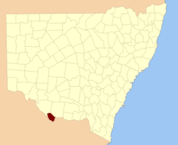
  • Cadell County, New South Wales — Infobox Australian cadastral name = Cadell state = New South Wales caption = Location in New South Wales near nw = Wakool near n = Townsend near ne = Townsend near e = Townsend near sw = Gunbower (Vic) near s = Rodney (Vic) near se = Moira (Vic)… …   Wikipedia

  • Cadell ap Rhodri — Mittelalterliche Königreiche in Wales. Der Herrschaftsbereich von Cadell ap Rhodri (das spätere Königreich Deheubarth) in Hellgrau Cadell ap Rhodri (* 854/861; † 909) war als Teil Nachfolger seines Vaters Rhodris des Großen in der Zeit von 878… …   Deutsch Wikipedia

  • County of Moira — Moira Victoria Location in Victoria Lands administrative divisions around Moira …   Wikipedia

  • County of Rodney — Infobox Australian cadastral name = Rodney state = Victoria caption = Location in Victoria est = 24 Feb 1871 area = 4400 near nw = Gunbower near n = Cadell (NSW) near ne = Moira near e = Moira near se = Moira near s = Dalhousie near sw = Bendigo… …   Wikipedia

  • County of Gunbower — Gunbower Victoria Location in Victoria Lands administrative divisions around Gunbower …   Wikipedia

  • County of Rodney, Victoria — Rodney Victoria Location in Victoria Established: 24 February 1871 Area: 4400 km² …   Wikipedia

  • Henry Moubray Cadell — (* 30. Mai 1860 in Crawhill, Schottland; † 19. April 1936[1]) war ein schottischer Geologe. Er studierte in Edinburgh und Clausthal und erwarb 1882 seinen B.Sc. in Edinburgh. Ab dem folgenden Jahr arbeitete er als Geologe am Geological Survey in… …   Deutsch Wikipedia

  • Urana County — Map of all coordinates from Google Map of all coordinates from Bing Export all coordinates as KML …   Wikipedia

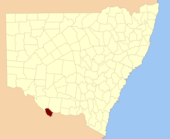
  • Townsend County, New South Wales — Infobox Australian cadastral name = Townsend state = New South Wales caption = Location in New South Wales near nw = Waradgery near n = Waradgery near ne = Boyd near e = Urana near se = Denison near s = Moira (Vic) near sw = Cadell near w =… …   Wikipedia

  • Townsend County — Map of all coordinates from Google Map of all coordinates from Bing Export all coordinates as KML …   Wikipedia

Share the article and excerpts

Direct link
Do a right-click on the link above
and select “Copy Link”