- Districts of Pakistan
-
Pakistan 
This article is part of the series:
Politics and government of
PakistanConstitutionPresidentJudiciaryAdministrative units
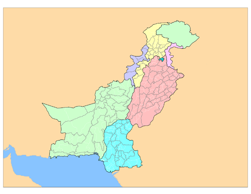
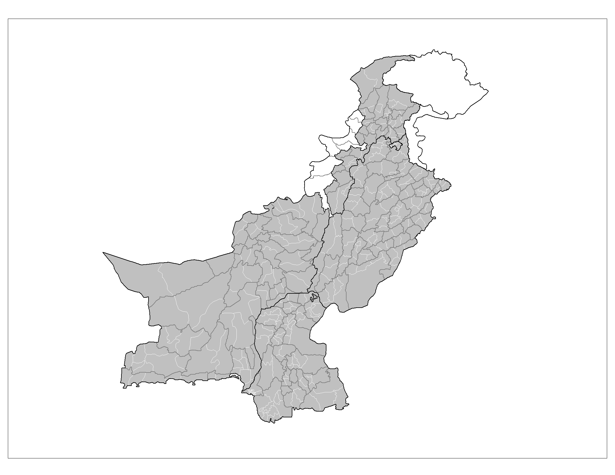
The Districts of Pakistan (Urdu: اضلاع پاکستان ) are the second order administrative divisions of Pakistan. Districts were the third order of administrative divisions, below provinces and "divisions", until the reforms of August 2000, when "divisions" were abolished. Districts now form the top tier of a three-tier system of local government with the two lower tiers composed of approximately 596 tehsils (included the Kashmir region) and more than 6,000 union councils.
Prior to 2001, there were 106 districts but with the reorganisation, these were reduced to 102 by the merger of the five districts of Karachi Central, Karachi East, Karachi South, Karachi West and Malir to form Karachi District. The five districts had formed the division of Karachi which was abolished. The number of districts rose to 106 again in December 2004, when four new districts[1] were created in the province of Sindh of which one (Umerkot) had existed until 2000 and three districts (Kashmore, Qambar and Jamshoro) were newly created.
In May 2005, the Punjab provincial government created a new district[2] by raising the status of Nankana Sahib from a tehsil of Sheikhupura District to a district in its own right.
In Azad Kashmir, the second tier of government is formed by three administrative divisions with a third tier of ten districts. In Gilgit-Baltistan, there are six districts divided between the two regions of Gilgit and Baltistan; Baltistan being a part of Ladakh under Pakistani control, the other part being under Indian control.
Contents
Overview
 Azad Jammu and KashmirIndia
Sr. No. Subdivision Districts Area (km²) Population (1998) Density (people/km²) 1 Balochistan 30 [3] 347,190 6,566,000 18.9 2 Khyber Pakhtunkhwa 24 [4] 74 521 17,744,000 238.1 3 Punjab 36 [5] 205,345 73,621,000 358.52 4 Sindh 23 [6] 140,914 30,440,000 216.02 5 Islamabad Capital Territory 1 906 805,000 880.8 6 Federally Administered Tribal Areas (FATA) 7 tribal agencies and 6 frontier regions 27,220 3,176,000 116.7 7 Azad Kashmir 10 13,297 2,972,500 258 8 Gilgit-Baltistan 7 72,971 1,800,000 24.8 Islamabad Capital Territory
Capital Territory Area (km²) Population (1998) Density (people/km²) Islamabad 906 805,235 889 Balochistan
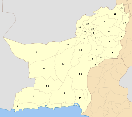
Sr. No. District Headquarters Area (km²) Population (1998) Density (people/km²) 1 Awaran Awaran 29,510 118,173 4 2 Barkhan Barkhan 3,514 103,545 29 3 Bolan Dhadar 7,499 288,056 38 4 Chagai[7] Chagai 44,748[8] 300,000 7 5 Dera Bugti Dera Bugti 10,160 181,310 18 6 Gwadar Gwadar 12,637 185,498 15 7 Harnai[9] 4,096 140,000 19 8 Jafarabad Jafarabad 2,445 432,817 177 9 Jhal Magsi Jhal Magsi 3,615 109,941 30 10 Kalat Kalat 6,622 237,834 36 11 Kech (Turbat) Kech 22,539 413,204 18 12 Kharan[10] Kharan 8958 1,32,500 4 13 Kohlu Kohlu 7,610 99,846 13 14 Khuzdar Khuzdar 35,380 417,466 12 15 Killa Abdullah Chaman 3,293 370,269 112 16 Killa Saifullah Killa Saifullah 6,831 193,553 28 17 Lasbela Bela 15,153 312,695 21 18 Loralai Loralai 9,830 295,555 30 19 Mastung Mastung 5,896 179,784 30 20 Musakhel Musa Khel Bazar 5,728 134,056 23 21 Nasirabad Nasirabad 3,387 245,894 73 22 Nushki[11] Nushki 5,797 137,500 23 23 Panjgur Panjgur 16,891 234,051 14 24 Pishin Pishin 7,819 367,183 47 25 Quetta Quetta 2,653 744,802 281 26 Sherani[12] Sherani 27 Sibi[9] Sibi 7,796 180,398 23 28 Washuk[10] 29 Zhob[12] Zhob 20,297 275,142 14 30 Ziarat Ziarat 1,489 33,340 22 Khyber Pakhtunkhwa
Map Sr. No. District Headquarters Area (km²) Population (1998) Density (people/km²) 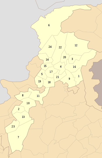
1 Abbottabad Abbottabad 1,967 880,666 448 2 Bannu Bannu 1,227 675,667 551 3 Battagram Battagram 1,301 307,278 236 4 Buner Daggar 1,865 506,048 271 5 Charsadda Charsadda 996 1,022,364 1,026 6 Chitral Chitral 14,850 318,689 21 7 Dera Ismail Khan Dera Ismail Khan 7,326 852,995 116 8 Hangu Hangu 1,097 314,529 287 9 Haripur Haripur 1,725 692,228 401 10 Karak Karak 3,372 430,796 128 11 Kohat Kohat 2,545 562,644 221 12 Kohistan Dassu 7,492 472,570 63 13 Lakki Marwat Lakki Marwat 3,164 490,025 155 14 Lower Dir Timergara 1,582 717,649 454 15 Malakand 952 452,291 475 16 Mansehra Mansehra 4,579 1,152,839 252 17 Mardan Mardan 1,632 1,460,100 895 18 Nowshera Nowshera 1,748 874,373 500 19 Peshawar Peshawar 1,257 2,019,118 1,606 20 Shangla Alpuri 1,586 434,563 274 21 Swabi Swabi 1,543 1,026,804 665 22 Swat Saidu Sharif 5,337 1,257,602 236 23 Tank Tank 1,679 238,216 142 24 Upper Dir Dir 3,699 575,858 156 Punjab
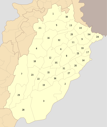
Sr. No. District Headquarters Area (km²) Population (1998) Density (people/km²) 1 Attock Attock 6,858 1,274,935 186 2 Bahawalnagar Bahawalnagar 8,878 2,061,447 232 3 Bahawalpur Bahawalpur 24,830 2,433,091 98 4 Bhakkar Bhakkar 8,153 1,051,456 129 5 Chakwal Chakwal 6,524 1,083,725 166 6 Chiniot Chiniot 965,124 7 Dera Ghazi Khan Dera Ghazi Khan 11,922 1,643,118 138 8 Faisalabad Faisalabad 5,856 5,429,547 927 9 Gujranwala Gujranwala 3,622 3,400,940 939 10 Gujrat Gujrat 3,192 2,048,008 642 11 Hafizabad Hafizabad 2,367 832,980 352 12 Jhang Jhang 8,809 2,834,545 322 13 Jhelum Jhelum 3,587 936,957 261 14 Kasur Kasur 3,995 2,375,875 595 15 Khanewal Khanewal 4,349 2,068,490 476 16 Khushab Khushab 6,511 905,711 139 17 Lahore Lahore 1,772 6,318,745 3,566 18 Layyah Layyah 6,291 1,120,951 178 19 Lodhran Lodhran 2,778 1,171,800 422 20 Mandi Bahauddin Mandi Bahauddin 2,673 1,160,552 434 21 Mianwali Mianwali 5,840 1,056,620 181 22 Multan Multan 3,720 3,116,851 838 23 Muzaffargarh Muzaffargarh 8,249 2,635,903 320 24 Narowal Narowal 2,337 1,265,097 541 25 Nankana Sahib[2] Nankana Sahib 2,960 1,410,000 26 Okara Okara 4,377 2,232,992 510 27 Pakpattan Pakpattan 2,724 1,286,680 472 28 Rahim Yar Khan Rahim Yar Khan 11,880 3,141,053 264 29 Rajanpur Rajanpur 12,319 1,103,618 90 30 Rawalpindi Rawalpindi 5,286 3,363,911 636 31 Sahiwal Sahiwal 3,201 1,843,194 576 32 Sargodha Sargodha 5,854 2,665,979 455 33 Sheikhupura Sheikhupura 5,960 3,321,029 557 34 Sialkot Sialkot 3,016 2,723,481 903 35 Toba Tek Singh Toba Tek Singh 3,252 1,621,593 499 36 Vehari Vehari 4,364 2,090,416 479 Sindh
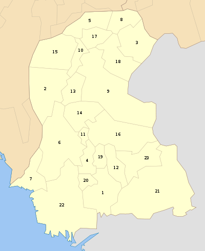
Sr. No. District Headquarters Area (km²) Population (1998) Density (people/km²) 1 Badin Badin 6,726 1,136,044 169 2 Dadu Dadu 19,070 1,688,811 89 3 Ghotki Mirpur Mathelo 6,083 970,549 160 4 Hyderabad Hyderabad 5,519 5,000,000 524 5 Jacobabad Jacobabad 5,278 1,425,572 270 6 Jamshoro[1] Jamshoro 7 Karachi Karachi 3,527 13,215,631 2,795 8 Kashmore[1] Kashmore 2,592 662,462 255 9 Khairpur Khairpur 15,910 1,546,587 97 10 Larkana Larkana 7,423 1,927,066 260 11 Matiari Matiari 1,417 515,331 364 12 Mirpurkhas Mirpur Khas 2,925 1,569,030 536 13 Naushahro Firoze Naushahro Feroze 2,945 1,087,571 369 14 Shaheed Benazirabad Nawabshah 4,502 1,071,533 238 15 Qambar Shahdadkot Qambar 16 Sanghar Sanghar 10,728 1,453,028 135 17 Shikarpur Shikarpur 2,512 880,438 350 18 Sukkur Sukkur 5,165 908,373 176 19 Tando Allahyar Tando Allahyar 2,310 550,000 20 Tando Muhammad Khan Tando Muhammad Khan 1,733 447,215 257 21 Tharparkar Mithi 19,638 914,291 47 22 Thatta Thatta 17,355 1,113,194 64 23 Umerkot[13] Umerkot 663,100 Federally Administered Tribal Areas
Map Sr. No. Agency Area (km²) Population (1998) Density (people/km²) 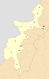
1 Bajaur 1,290 595,227 461 2 Khyber 2,576 546,730 212 3 Kurram 3,380 448,310 133 4 Mohmand 2,296 334,453 146 5 North Waziristan 4,707 361,246 77 6 Orakzai 1,538 225,441 147 7 South Waziristan 6,620 429,841 65 8 Bannu 745 19,593 26 9 Dera Ismail Khan 2,008 38,990 19 10 Kohat 446 88,456 198 11 Lakki Marwat 132 6,987 53 12 Peshawar 261 53,841 206 13 Tank 1,221 27,216 22 Azad Jammu and Kashmir
Map Sr. No. District Area (km²) Population (1998) Density (people/km²) 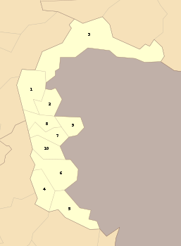
1 Muzaffarabad 2,496 615,000 375 2 Hattian 854 225,000 263 3 Neelum 3,621 171,000 47 4 Mirpur 1,010 419,000 415 5 Bhimber 1,516 401,000 265 6 Kotli 1,862 746,000 401 7 Poonch 855 524,000 613 8 Bagh 1,368 351,000 456 9 Haveli 598 138,000 231 10 Sudhnati 569 278,000 489 Gilgit-Baltistan
Main article: Districts of Gilgit-BaltistanMap Sr. No. District Area (km²) Population (1998) 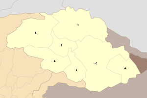
1 Ghanche 6,400 88,366 2 Skardu 15,000 214,848 3 Astore 8,657 71,666 4 Diamer 10,936 131,925 5 Ghizer 9,635 120,218 6 Gilgit 26,300 243,324 7 Hunza-Nagar See also
- Administrative units of Pakistan
- List of Pakistani Districts by Human Development Index
References
- ^ a b c Site Edition, Daily Times Newspaper. "Four new districts in Sindh". http://www.dailytimes.com.pk/default.asp?page=story_14-12-2004_pg7_36. Retrieved 2006-04-14.
No data is yet available on the recently-created districts of Sindh province. - ^ a b Internet Edition, Dawn Newspaper. "Nankana becomes district". http://www.dawn.com/2005/05/10/nat43.htm. Retrieved 2006-04-14.
No data is yet available on the recently-created district of Nankana. - ^ [1]
- ^ [2]
- ^ [3]
- ^ [4]
- ^ No figures available yet - Nushki was part of Chagai district
- ^ http://www.dailytimes.com.pk/default.asp?page=2011\01\20\story_20-1-2011_pg1_8
- ^ a b No figures available yet - Harnai was part of Sibi district ("Harnai is new district of Balochistan". Dawn Media Group. http://www.dawn.com/2007/08/31/top14.htm. Retrieved 2010-08-28.)
- ^ a b No figures available yet - Washuk was part of Kharan district
- ^ http://www.arcpakistan.org/html/cyclone/AssessmentReport.pdf
- ^ a b No figures available yet - Sherani was part of Zhob district
- ^ District Government Umerkot
External links
- Population Census Organization, Government of Pakistan. "List of Districts/Agencies/Tribal Areas". http://www.statpak.gov.pk/depts/pco/statistics/admin_unit/admin_list.html. Retrieved 2006-04-14.
- Population Census Organization, Government of Pakistan. "List of Tehsils/Talukas with respect to their Districts". http://www.statpak.gov.pk/depts/pco/statistics/admin_unit/admin_list_tehsil.html. Retrieved 2006-04-14.
- Country Profiles, South Asian Media Net. "Pakistan >> District Profiles". http://www.southasianmedia.net/profile/pakistan/pakistan_districprofiles.cfm. Retrieved 2006-04-14.
- Northern Pakistan detailed placemarks in Google Earth (with an overlay for district boundaries
- Current map of the Districts of Sindh
Articles on second-level administrative divisions of Asian countries Afghanistan · Armenia2 · Bangladesh · Bhutan · Brunei · Burma · Cambodia · People's Republic of China · Cyprus1 · Egypt1 · Georgia1 · India · Indonesia · Iran · Iraq · Israel · Japan · Jordan · Kazakhstan1 · North Korea · South Korea · Kuwait · Kyrgyzstan · Laos · Lebanon · Malaysia · Mongolia · Nepal · Oman · Pakistan · Philippines · Russia1 · Saudi Arabia · Sri Lanka · Syria · Taiwan · Tajikistan · Thailand · Timor-Leste (East Timor) · Turkey1 · Turkmenistan · Uzbekistan · Vietnam · Yemen
1 Country spanning more than one continent (transcontinental country).
Table of administrative country subdivisions by country Categories:- Districts of Pakistan
- Lists of country subdivisions
- Country subdivisions of Asia
- Second-level administrative country subdivisions
- Pakistan-related lists


Wikimedia Foundation. 2010.