- Ghizer District
Infobox Pakistan district
district = Ghizer District
area =
population =
pop_year =
density =
caption = Map of the Northern Areas of Pakistan, showing the six districts and tehsil boundaries.
region =Northern Areas
established =
nazim =
naib_nazim =
seats =
tehsils =
languages =
website =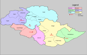
Ghizer District is northernmost part of the
Northern Areas ofPakistan . Its capital isGakuch . Ghizer is also a contact point betweenGilgit andChitral (which are connected viaShandur Pass ). Ghizer is a multi ethnic district and three major languages are spoken.Khowar ,Shina andBurushaski are spoken in Ghizer. There are also a fewWakhi speakers inIshkoman .History
Historically the region has been ruled by indigenous rajas such as those of
Yasin andPunial and later it was divided between theMehtar ofChitral and theMaharaja of Kashmir. After1895 all of Ghizer was annexed toGilgit Agency which was directly ruled by the British Govt. and not by the Kashmir Durbar.Tehsil gupis is the central part of Ghizer district. there are so many villages lush green and very pleasant places, like Phunder, Khalti, the most biggest Jell in khalti is very famous for tout fishes.there are also PTDC Hotel available
The Rajas of
Yasin Suleman Shah andGohar Aman stretched their rule to Gilgit by pushing back Dogras and at some particular juncture of history remained defacto rulers of the region stretched from Yasin to Gilgit. Latter on after the death ofGohar Aman due to the internal conspiracy the Dogras of Maharaja Kashmir came toYasin andModori debacle occurred inYasin Geography
District
Ghizer is Northmost part of theNorthern Areas and hence the extreme north of the country. It joins with Wakhan strip on its north-west, and China on its northern borders. On its west, there is Chitral District of NWFP; and on its east is situated Gilgit. Diamer District is on its south, which is again a part of the Northern areas.Gakuch is the capital of the Ghizer District.The highest peak in Ghizer District is
Koyo Zum (6,871 m) (Hindu Kush Range) which lies on the boundary of Ghizer District andChitral .Some of the main places in the district are
Ishkoman andYasin valleys. Other places includeGupis ,Chatorkhand ,Imit andUtz .Passes
Some of the passes in the district are:
*Karumbar Pass ,Chillingi Pass .
*Hayal Pass andNaltar Pass (on the boundary of Ghizer andGilgit District s).
*Bichhar Pass (on the boundary of Ghizer andGilgit District s).
*Thoi Pass (on the boundary of Ghizer andChitral Yarkhon).
*Darkut Pass (on the boundary of Ghizer andChitral ).Rivers
The main river in the district is Ghizer River, which is known as
Gilgit River in the east of Gupis town. Some of its tributaries include Karambar River, Ishkoman River, Phakora River, Hayal River and Yasin River.Tehsils *
Gupis .
*Ishkoman .
*Punial .
*Yasen .Gahkuch is the district headquarter of Ghizer district.
Languages
* Burushaski spoken in Yasin.
*Khowar spoken in Yasin, Gupis and Ishkoman.
*Shina spoken in Gupis and Punail.
*Wakhi spoken in Ishkoman.ee also
*
Districts of Northern Areas
*Northern Areas

Wikimedia Foundation. 2010.