Diamer District

Diamer District
Diamer District
—  District  —
Map of the Northern Areas of Pakistan, showing the six districts and tehsil boundaries.
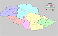
Country  Pakistan
Province
Capital Chilas
Established
Government
 – District Nazim
 – District Naib Nazim
Time zone PST (UTC+5)
District Council

Diamer District is one of the seven districts of the Northern Areas of Pakistan. It is the district in which the Karakoram Highway enters that territory from the North-West Frontier Province, the capital of the district is Chilas. In 2004, Diamer District was bifurcated and the district of Astore was created from Diamer's easternmost tehsil.

Diamer District is bounded by Astore District in the east, by the North-West Frontier Province in the southwest (separated by the Babusar Pass or Babusar Top), Neelum District of Azad Kashmir in the south, the Ghizer District in the north and northwest, and the Gilgit District in the north and northeast.

Before the Karakoram Highway was opened in 1978, the only road reaching Gilgit town from the south was a rough track north from Balakot to Babusar Pass (via Kaghan, Naran, Besal, and Gittidas) and further north through Babusar Gah to Chilas. The road up to Besal is now in better condition, but from Besal to Babusar Pass, the road is still a rough track.

See also

  • Districts of Gilgit-Baltistan

External links


Wikimedia Foundation. 2010.

Игры ⚽ Нужно решить контрольную?

Look at other dictionaries:

  • Diamer-Bhasha Dam — Diamer Bhasha Dam …   Wikipedia

  • Diamer — may refer to: Diamer District, Pakistan Diamer, Mauritania See also Diamer Bhasha Dam This disambiguation page lists articles about distinct geographical locations with the same name. If an …   Wikipedia

  • Neelum District —   District   Map of Azad Kashmir with Neelum District highlighted Neelum is the most northern district of Azad Kashmir …   Wikipedia

  • Ghizer District — Infobox Pakistan district district = Ghizer District area = population = pop year = density = caption = Map of the Northern Areas of Pakistan, showing the six districts and tehsil boundaries. region = Northern Areas established = nazim = naib… …   Wikipedia

  • Astore District — Infobox Pakistan district district = Astore District area = 5,092 population = 71,666 pop year = 1998 density = caption = Map of the Northern Areas of Pakistan, showing the six districts and tehsil boundaries region = Northern Areas (Pakistan)… …   Wikipedia

  • Диамер (округ) — Диамер (англ. Diamer District) Страна Пакистан Статус Округ Административный центр Хилас Офици …   Википедия

  • Diamir — or Diamer may refer to: Diamir, the west face of Nanga Parbat; Diamer District, in the Northern Areas of Pakistan. This disambiguation page lists articles associated with the same title. If an internal link le …   Wikipedia

  • Douan — Douan, also known as Doyian, is a small village in the Astore district of Northern Pakistan. It is at the base of the Himalayas. The road to the village famously has 17 uphill turns. The village is divided into Ajjay Douan and Khariyee Douan… …   Wikipedia

  • Chilas — Overview map of the Karakoram Highway Chilas (Urdu: چلاس) is a small town located in the Gilgit Baltistan, Pakistan on the left side of river Indus. It is part of the Silk Road connected by the Karakoram Highway which links it to Islamabad in the …   Wikipedia

  • Geography of Gilgit-Baltistan — Districts of Gilgit Baltistan Gilgit Baltistan has been under Pakistani control since 1947 and was given full autonomy on August 29, 2009 and is now constitutionally an integrated part of Pakistan.[1] Gilgit Baltistan comprises seven districts… …   Wikipedia

Share the article and excerpts

Direct link
Do a right-click on the link above
and select “Copy Link”