- Gilgit District
Infobox Pakistan district
district = Gilgit District
area =
population =
pop_year =
density =
caption = Map of the Northern Areas of Pakistan, showing the six districts and tehsil boundaries.
region =Northern Areas
established =
nazim =
naib_nazim =
seats =
tehsils =
languages =
website =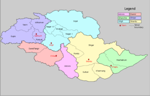
Gilgit District is bounded by
Wakhan Corridor (Afghanistan ) in the north,Xinjiang (China ) in the north / northeast,Skardu District in the south / southeast. The town ofGilgit is the capital of Gilgit District.The district includes
Gilgit town,Naltar ,Hunza ,Gojal (Upper Hunza ) andShimshal . It also includes many small villages likeMinapin ,Hopar andHispar etc. The highest peak in the district isDistaghil Sar (7,885m) which is the seventh highest peak inPakistan and 19th highest onearth .The Northern Areas 1998 census gave its population as 243,324.
Administration
The district is administratively subdivided into the following
tehsil s:*
Aliabad Tehsil
* Gilgit City
*Gojal
*Nagar I
*Nagar II Geography
Only a part of the basin of the
Gilgit River ,i.e.Gilgit Valley is included within the political boundaries of Gilgit District. There is an intervening width of mountainous country, represented chiefly byglacier s andice field s, and intersected by narrow sterile valleys, measuring some convert|100|m|ft to convert|150|m|ft| in width, to the north and north-east, which separates the province of Gilgit from the Chinese frontier beyond theMuztagh andKarakoram . Towering above Gilgit is Mount Rakaposhi at convert|7788|m|ft|sigfig=5.Rivers in Gilgit District
The main rivers in the District are:
*Khunjerab River - flows south along theKarakoram Highway from theKhunjerab Valley , known asHunza River in the south ofSust
*Hunza River - flows further south and falls intoGilgit River just in the northeast ofGilgit town
*Gilgit River - enters Gilgit District from west in the south ofBichhar Pass (Naltar Valley ) and flows west through the Gilgit town.
*Indus River - enters Gilgit District fromSkardu District about six kilometers north ofJaglot whereGilgit River falls intoIndus River and the Indus flows south along the Karakoram Highway.
**Astor River There are many tributaries of the above main rivers, some of which are
Ghujerab River ,Shimshal River ,Hispar River ,Naltar River andYaheen River .Passes in Gilgit District
*
Khunjerab Pass ,Mintika Pass ,Kilik Pass ,Chillingi Pass ,Shimshal Pass ,Ghujerab Pass ,Chapchingal Pass ,Chaprot Pass ,Naltar Pass andTalmutz Pass .Lakes in Gilgit District
*
Naltar Lake s
*Borit Lake
*Rush Lake (Rush Peak )ee also
*
Districts of Northern Areas

Wikimedia Foundation. 2010.