- Geography of Gilgit-Baltistan
-
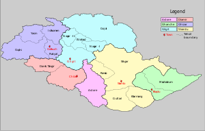 Districts of Gilgit-Baltistan
Gilgit-Baltistan has been under Pakistani control since 1947 and was given full autonomy on August 29, 2009 and is now constitutionally an integrated part of Pakistan.[1] Gilgit-Baltistan comprises seven districts within two divisions of Pakistan. The two districts of Skardu and Ghanche are in the Baltistan Division, and the five districts of Diamir, Ghizar, Gilgit, Astore (which was carved out of the Diamir District in 2004)and Hunza-Nagar which was carved out of Gilgit District are in the Gilgit Division. The main political centres are the towns of Gilgit and Skardu.
Gilgit-Baltistan is home to some of the world's highest mountain ranges. The main ranges are the Karakoram and the western Himalayas. The Pamir mountains are to the north and the Hindu Kush lies to the west. Amongst the highest mountains are K2 (Mount Godwin-Austen) and Nanga Parbat, one of the most feared mountains in the world.
Many of the highest peaks in Gilgit-Baltistan, such as Baltoro Muztagh, K2 (Mount Godwin-Austen) (8,611 m), the second-highest mountain in the world), the Gasherbrums (7,932 - 8,080 meters, ranked 12-17 in the world), and Masherbrum (7,821 m), 22nd-highest in the world), lie in the Skardu District. Other high peaks are Distaghil Sar (7,885 meters, 19th-highest in the world), Kunyang Chhish (7,852 meters, 21st-highest in the world), Batura Sar (7,795 m), 25th-highest in the world), Kanjut Sar (7,790 m), 26th-highest in the world), and Rakaposhi (7,788 m), 27th-highest in the world.
Contents
Hunza-Nagar District
The Hunza-Nagar district formerly princely state Nagar State and Hunza, (Upper Hunza. It also includes many small villages.
Gilgit District
The Gilgit District is bounded by the Wakhan Corridor of (Afghanistan) in the north, Xinjiang (China) in the north and northeast, Skardu District in the south and southeast. The capital of the Gilgit District is Gilgit town.
The district includes Gilgit town, Naltar,Nagar State Hunza, Gojal (Upper Hunza) and Shimshal. It also includes many small villages like Minapin, Hopar, and HisparNgar KHaas, Symayer, Askurdas, Shahyaar, Hakochar, Phaker,Dadimal,Miacher, Pisson, Yell, Ghulment, Masoot, Thole, Nilt, Jafferabad, Sikandarabd, Chalt Chaproat, Bodlas in the Ex. State of Nagar. The Haramosh valley, currently located within the Gilgit District, was previously located within the Skardu District. The highest peak in the Gilgit District is Distaghil Sar (7,885 m), which is the 19th-highest mountain in the world.
Rivers in Gilgit District
Main rivers in the Gilgit District are:
- Khunjerab River - flows south along the Karakoram Highway from the Khunjerab Valley and is known as the Nagar River, Hunza River south of Sust.
- Nagar River - flows further south and enters the Gilgit River by touching Hunza River to Gilgit
- Hunza River - flows further south and enters the Gilgit River just to the northeast of Gilgit town.
- Gilgit River - enters the Gilgit District from the west, south of the Bichhar Pass (Naltar Valley), and flows west through Gilgit town.
- Indus River - enters the Gilgit District from the Skardu District about six kilometers north of Jaglot, where the Indus River is joined by the Gilgit River. From there, the Indus flows south along the Karakoram Highway.
There are many tributaries of the aforementioned rivers, some of which are the Ghujerab River, the Shimshal River, the Hispar River, and the Naltar River.
Passes in Gilgit District
- Khunjerab Pass, Mintika Pass, Kilik Pass, Chillingi Pass, Shimshal Pass, Ghujerab Pass, Chapchingal Pass, Chaprot Pass, Naltar Pass, and Talmutz Pass.
Lakes in Gilgit District
- Naltar Lakes
- Kachaily Lake Between Miacher and Minpin just front side of Rakaposhi in Nagar
- Borit Lake
- Rush Lake (Rush Peak)
Skardu District
The capital of the Skardu District is Skardu town. Skardu was part of Ladakh before the partition of Kashmir in 1948. The Baltoro Muztagh, the subrange of the Karakoram that includes the mighty peaks of K2 (8,611 m), Broad Peak (8,047 m), the Gasherbrums (8,000+ meters) and Masherbrum (7,821 m), is included in the Skardu District. Askole is the last settlement in the district for all treks to Concordia, the confluence of the Baltoro Glacier and the Mount Godwin-Austen Glacier). The Biafo Glacier and a major part of the Hispar Glacier are also located in the Skardu District. The district also includes almost all of the Deosai National Park, which is located on the second-highest plateau in the world. (Only the Tibetan Plateau is higher). Skardu also is the district in which the Indus River enters Gilgit-Baltistan from the Indian state of Jammu and Kashmir.
Other towns in the Skardu District include:
- Marol, Faranshat and Gultari near the Line of Control.
- Parkutta, Shigar, Niyil, Rondu.
The highest peak in the Skardu District is K2 (8,611 m), which is the second-highest peak in the world.
Hispar Pass and Gondoghoro Pass are also in the Skardu District. Some of the lakes in the district are Snow Lake, Satpara Lake, Sheosar Lake, Kachura Lake, and Shangrila Lake.
Ghanche District
The Ghanche District ("Ghanche" means the 'great glacier' and is written as "Gangche" by the local people) is the easternmost district of Baltistan. To the east is the Leh District of Ladakh. Northeast is Aksai Chin, (China), to the north and northwest is the Skardu District, to the west is the Astore District, and to the south is the Indian state of Jammu and Kashmir. The Line of Control along the easternmost region of the Ghanche District ends before the start of the Siachen Glacier. (There has been a proposal made to turn the Siachen Glacier region into a peace park.)
The capital of the Ghanche District is Khaplu. The Khaplu and Hushe Valleys form the gateway for the great Baltoro Muztagh, the subrange of the Karakoram that includes the mighty peaks of K2 (8,611 m), Broad Peak (8,047 m), the Gasherbrums (8,000+ meters), and Masherbrum (7,821 m)--all of which are located in the Skardu District.
The highest peak in Ghanche District is Saltoro Kangri (7,742 m), which is the 31st-highest peak in the world and is, in fact, under Indian control since 1984.
Some of the towns in the district are Balghar, Dubla Khan, Doghani, and Lunkha.
Some rivers in the district are the shyok River, the Hushe River, and the Thalle River.
Ghizar District
The Ghizar District is the westernmost district of the Gilgit-Baltistan. It is bounded by Pakistan's Khyber Pakhtunkhwa province on three sides (north, west, and south), by the Diamir District in the south and southeast, and by the Gilgit District in the east. A small strip of the Ghizar District (roughly 35x12 km) is sandwiched between the Khyber Pakhtunkhwa and the Wakhan Corridor of (Afghanistan). The capital of the Ghizar District is Gakuch.
The highest peak in the Ghizar District is Koyo Zum (6,871 m) in the (Hindu Kush Range) which lies on the boundary of the Ghizar District and the Khyber Pakhtunkhwa.
Some of the main places in the district are the Gulapur, singul, Ishkoman, and the Yasin valleys. Other places include Gupis, Chatorkhand, Imit, and Utz.
Some of the passes in the district are:
- Karumbar Pass, Chillingi Pass.
- Hayal Pass and Naltar Pass (on the boundary of Ghizar and Gilgit Districts).
- Bichhar Pass (on the boundary of Ghizar and Gilgit Districts).
The main river in the district is the Ghizar River, which is known as the Gilgit River to the east of Gupis town. Some of its tributaries include the Karambar River, the Ishkoman River, the Phakora River, and the Hayal River.
Diamir District
The Diamir District is the district where the Karakoram Highway enters Gilgit-Baltistan from Pakistan's Khyber Pakhtunkhwa. The capital of the Diamir District is Chilas. The Diamir District is bounded by the Astore District in the east, the Khyber Pakhtunkhwa in the south and southwest (separated by the Babusar Pass or Babusar Top), the Ghizar District in the north and northwest, and the Gilgit District in the north and northeast. The valleys of Darel-Tangir, which are currently part of Gilgit-Baltistan, were formerly part of Pakistan.
District Diamer is divided in to two sub-divisions one is Chilas and the other one is Darel/Tangir. Village Juglote is headquarter of sub-division Darel/Tangir while Chilas is the headquarter of other sub-division and also headquarter on district Diamer.
Before the Karakoram Highway was opened in 1978, the only road to Gilgit town from the south was a rough track north from Balakot to Babusar Pass (via Kaghan, Naran, Besal, and Gittidas) and further north through Babusar Gah to Chilas. The road up to Besal is now in better condition, but the road from Besal to Babusar Pass is still a rough track.
Astore District
The Astore District was carved out of the Diamir District in 2004. Before that date, Gilgit-Baltistan was composed of five districts.
The capital of the Astore District is Gorikot, which includes many villages in the Astore Valley.
Astore district comprised the area of erstwhile Gilgit Wazarat.
The Astore District is bounded by the Diamir District in the west and the Skardu District in the east.
Some notable places in the district are Tarashing, Rupal, and Rama Lake.
See also
References
External links
See also: Administrative units of PakistanCategories:- Districts of Gilgit-Baltistan

Wikimedia Foundation. 2010.