- Hunza (princely state)
Infobox Former Pakistan subdivision
subdivision = Hunza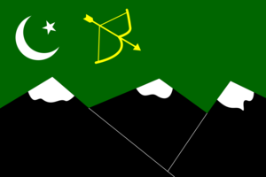
capital = Baltit (Karimabad)
area = 10,101
languages = Burushaski,Wakhi| Shina
established =15th century
abolished =25 September 1974
footnotes = [http://www.northernareas.gov.pk Northern Areas Government]Hunza (
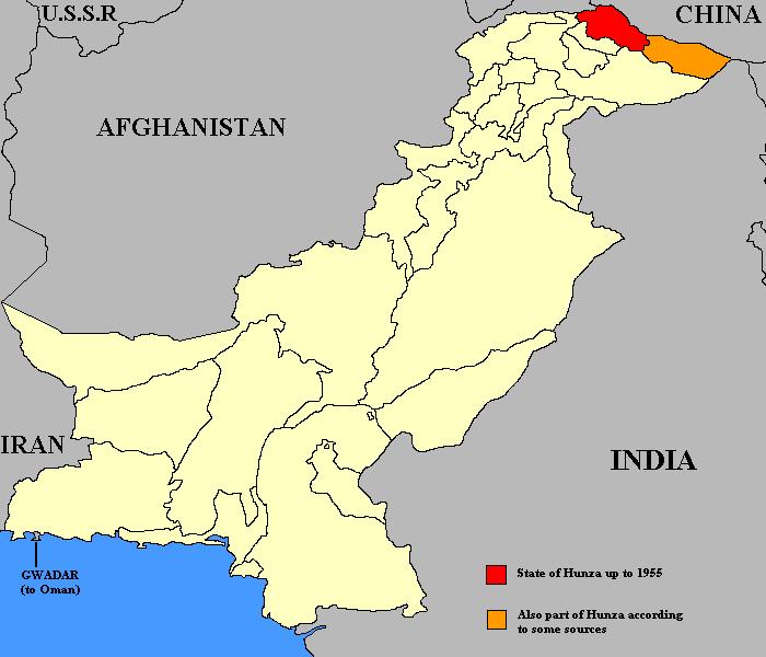
Urdu : ہنزہ) was a formerprincely state in the northernmost part of the Northern Areas ofPakistan , which existed until 1974. The state bordered theGilgit Agency to the south, the former princely state of Nagar to the east,China to the north andAfghanistan to the northwest. The state capital was the town of Baltit (also known as Karimabad). The area of Hunza now forms the Aliabadtehsil ofGilgit District .History
Hunza was an independent principality for 900 years. The British gained control of Hunza and the neighbouring valley of Nagar between 1889 and 1892. The Tham (Chief/Mir) of Hunza escaped to China.
The British retained Hunza's status as a '
principality ' until1947 . According toHabib R. Sulemani , the people of Hunza were ruled by a local Mir for more than 900 years, which came to an end in1974 .Although never ruled directly by neighbouring
Kashmir , Hunza was a vassal of Kashmir from the time of Maharaja Ranbir Singh ofJammu and Kashmir . The Mirs of Hunza sent an annual tribute to the KashmirDurbar until1947 , and along with the ruler of Nagar, was considered to be among the most loyal vassals of the Maharaja of Kashmir.Accession to Pakistan
On 3rd November 1947, the ruler, Mohammad Jamal Khan sent a telegram to
Mohammad Ali Jinnah acceding his state to Pakistan. ["Jinnah Papers The states: Historical and Policy Perspectives and Accession to Pakistan", First series volume VIII, Editor: Z.H.Zaidi, Quaid-i-Azam Papers Project, Government of Pakistan 2003 Pg 113] It stated:"I declare with pleasure on behalf of myself and my State accession to Pakistan"
Government
The state was governed by hereditary rulers who took the title Mir (ruler) and were assisted by a council of Wazirs or Ministers. Details for early rulers are uncertain with the first definite dates available from 1750 CE onwards.
Geography
The Hunza valley is situated at an elevation of 2,438 metres (7,999 feet). The former capital Baltit has an elevation of 2477 metres (8129 feet) [ [http://www.fallingrain.com/world/PK/7/Baltit.html Falling rain - Location of Baltit] ]
For many centuries, Hunza has provided the quickest access to Swat and
Gandhara for a person travelling on foot. The route was impassable to baggage animals; only human porters could get through, and then only with permission from the locals.Hunza was easily defended as the paths were often less than half a metre (about 18") wide. The high mountain paths often crossed bare cliff faces on logs wedged into cracks in the cliff, with stones balanced on top. They were also constantly exposed to regular damage from weather and falling rocks. These were the much feared "hanging passageways" of the early Chinese histories that terrified all, including several famous Chinese Buddhist monks.
The last independent ruler was Mir Safdar Khan, who ruled from 1886 to December 1891 - until the British conquest in December 1891. His younger brother Mir Mohammad Nazim Khan was installed by the British and Maharaja (Raja) of Kashmir in September 1892.History of The Northern Areas of Pakistan By Prof. A.H. Dani, Islamabad 1991]
Demographics
Most of the people of Hunza are Ismaili Muslims. The local languages are Brushuski, Wakhi and Shina although Urdu and English are also widely understood.
See also
*
Hunza Valley
*Northern Areas
*Karakoram Highway
*Karakoram Mountains
* NagarReferences
External links
* [http://www.northernareas.org.pk Government of Northern Areas]
* [http://www.pakistan.gov.pk Government of Pakistan]
* [http://www.piac.com.pk/piaspakistan/piaspakistan-northernareas2.asp PIA guide to Northern Areas]

Wikimedia Foundation. 2010.