- Dir (princely state)
-
This article is about the historical State of Dir. For other uses, see Dir (disambiguation).
 This article is part of the seriesFormer administrative units of PakistanOriginal provincesMinor statesOne-unit provincesOther subdivisions
Dir 
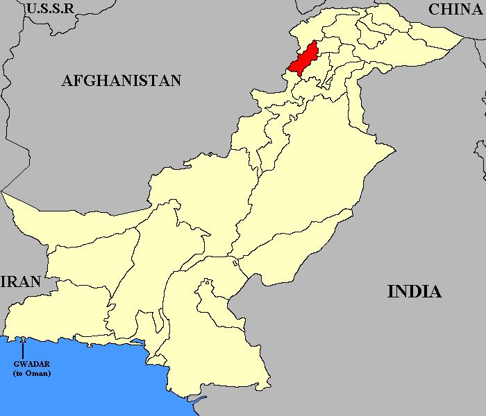
Capital Dir Area 5,282 km² Languages Pashto Established 1863 Abolished 28th July 1969 Dir was a small located in what is today Khyber-Pakhtunkhwa province of Pakistan. The state ceased to exist in 1969, when it was incorporated into Pakistan. The area once occupied by the state, 5,282 km2 (2,039 sq mi), now forms two districts of Pakistan – Upper Dir and Lower Dir. The two districts were part of Malakand Division until divisions were abolished as an administrative tier.
Geography
Most of the state lay in the valley of the Panjkora river, which originates in the Hindu Kush mountains and joins the Swat River near Chakdara. Apart from small areas in the south-west, Dir is a rugged, mountainous country with peaks rising to 5,000 metres (16,000 ft) in the north-east and to 3,000 metres (9,800 ft) along the watersheds, with Swat to the east and Afghanistan and Chitral to the west and north.
History
The State's relations with the British and the Raj were governed by the Agreement of 1925. Nawab Shah Jehan Khan was a harsh ruler. [1]
Division of Dir
Dir district was officially split into Upper Dir and Lower Dir in 1996. Until 2000 as funds were not available to provide the accommodation needed at Dir town by government departments at a district headquarters, both districts continued to he administered by a single deputy Commissioner stationed at Timergara.
UPPER DIR
Upper Dir is one the 24 districts of North-West Frontier Province, Pakistan. The district was formed in 1996, when the district of Dir was divided into Upper Dir and Lower DIR.
Location
Upper Dir district is 3,699 square kilometres in area and formed part of the former Malakand Division, lying along the Afghanistan border between Chitral and Peshawar.
Almost all of the district lies in the valley of the Panjkora river which rises high in the Hindu Kush at Lat. 35.45 and joins the Swat River near Chakdara, where the district is usually entered, at Lat. 34.40. Apart from the tehsils of Adenzai round Chakdara and Munda in the south-west, Dir is rugged and mountainous with peaks rising to 16,000 feet (4,900 m) in the north-east and to 10,000 ft (3,000 m), along the watersheds with Swat to the east and Afghanistan to the west.
It is connected with the Kohistan District via the Badawi Pass.
People
The majority of the population in this area are Yousafzai, Roghani Pashtuns speaking Pashto.
Administration
The district is administratively subdivided into six tehsils which contain a total of 31 Union Councils:[1]
Name of Tehsil No. of Unions
Barawal 3 , Chapar 1 , Dir 13 , Kalkot 3, Khal 3 , Wari 8 , Total 31,
Upper Dir is represented in the provincial assembly by three elected MPAs who represent the following constituencies: [2]
Constituency MPA Party
PF-91 (Upper Dir-I)[3] Muhammad Anwar Pakistan Peoples Party, PF-92 (Upper Dir-II) Bacha Salih Pakistan Peoples Party , PF-93 (Upper Dir-III) Hayat Khan Independent ,
Towns
The only motor road to Chitral reaches 10,234 ft (3,119 m) at the Lowarai Pass. However, the district headquarters, lies at only 2,700 ft (820 m), twice the altitude of Peshawar but much lower than the traditional and eponymous capital of Dir at the foot of the Lowarai. Except for them and a number of rapidly growing bazaar towns along the main roads, the population is rural, scattered in more than 1200 villages over the plains of Adenzai and Munda and the deep narrow valleys of the Panjkora and its tributaries.
Of these the largest are
Barawal , Karo , Nihag , Toormang, Usherai ,
LOWER DIR
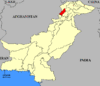
Location of Dir
within the North West Frontier Province of Pakistan
Lower Dir is one the 24 districts of North-West Frontier Province, Pakistan. Dir is an area of the North West Frontier Province that has been split into two districts, Upper Dir and Lower Dir districts.The district is 1,582 square kilometres in area[1] and formed part of the Malakand Division, lying along the Afghanistan border between Chitral and Peshawar. Almost all of it lies in the valley of the Panjkora which rises high in the Hindu Kush at Lat. 35.45 and joins the Swat River near Chakdara, where the district is usually entered, at Lat. 34.40. Apart from the tehsils of Adenzai round Chakdara and Munda in the south-west, Dir is rugged and mountainous with peaks rising to 16,000 feet (4,900 m) in the north-east and to 10,000 ft (3,000 m) along the watersheds with Swat to the east and Afghanistan to the west. The only motor road to Chitral reaches 10,234 ft (3,119 m) at the Lowarai Pass. Timergara, however, the district headquarters, lies at only 2,700 ft (820 m) twice the altitude of Peshawar but much lower than the traditional and eponymous capital of Dir at the foot of the Lowarai. Except for them and a number of rapidly growing bazaar towns along the main roads the population is rural, scattered in more than 1200 villages over the plains of Adenzai and Munda and the deep narrow valleys of the Panjkora and its tributaries. Of these the largest are Barawal, Usherai, Nihag, Karo and Toormang. Dir district was officially split into Upper Dir and Lower Dir in 1996. Until 2000 as funds were not available to provide the accommodation needed at Dir town by government departments at a district headquarters, both districts continued to he administered by a single deputy Commissioner stationed at Timergara.
Administration
The district is administratively subdivided into two Tehsils which contain a total of 13 Union Councils:[2]
Tehsil No. of Unions
Samar Bagh 6 Timargara 7 Total 13
The district is represented in the provincial assembly by four elected MPAs who represent the following constituencies: [3]
PF-94(Lower Dir-1) PF-95(Lower Dir-2) PF-96(Lower Dir-3) PF-97(Lower Dir-4)
Demographics
The population of the Lower Dir district's 37 Union Councils is 797,852 according to the 1998 census report. The projected population of Dir Lower was 1.037.091 in 2005 with the same growth between the 1981 and 1998 census i.e. 3.42% per annum. The projected male population of Dir lower in 2005 is 514,072 and the female is 523,020.
The literacy ratio of the district among the population aged 10 years and above is 29.90 percent which has increased significantly since 1981 when it was just 10.16 percent. The male literacy ratio is higher i.e. 48.76 compared to 12.25 percent for females, according to census report 1998.
Dir District is located in the north of North West Frontier Province. Dir has a long border with Afghanistan. Dir is considered the most sensitive area in Pakistan in term of religious extremism. Religio-political parties have good roots in Dir like JUI, JI and TNSM etc. The development indicators in Dir have always been discouraging. Dir was ruled by a princely dynasty till 1969. There were limited facilities for education, health, road, transportation and communication for the inhabitants of the Dir State.
Dir District was merged into Pakistan under a presidential order of the president of Pakistan. Dir was declared as Dir Agency, till 1969. It was declared as District running under Provincially Administered Tribal Area (PATA) till 1996. District Dir was bifurcated into Dir Upper and Dir Lower in 1996. District Dir Lower is composed of two sub divisions i.e. Timergara and Jandool (Samarbagh) Sub-divisions. During July/ August the provincial government shifted three ............................................................
Accession to Pakistan
On 18 February 1948 the ruler of Dir, Muhammad Shah Jehan, united his Princely State with the new Dominion of Pakistan.[2]
Demographics
At the Partition of India, there was a Muslim majority in Dir with small minorities of Hindus and Sikhs, many of whom left for India during partition.
The main language of the State of Dir was Pashto.
The population of Lower Dir District, with a total of 37 Union Councils, is 797,852, according to the 1998 census report. The projected population of Lower Dir was 1,037,091 in 2005, with the same growth between the 1981 and 1998 census (3.42% per annum). The projected male population of Lower Dir in 2005 was 514,072 and the female was 523,020.
Government
The rulers of Dir originally held the title of Khan, but from June 1897 onwards, they were styled Nawab Khan Bahadur of the Akhun Khel tribe. The royal status of the rulers was abolished in 1972, at the same time as most other princes of Pakistan.
Tenure Rulers of Dir[3] Unknown dates Gholam Khan Baba Unknown dates Zafar Khan Unknown dates Qasem Khan 1863–1874 Ghazzan Khan 1875–1886 Rahmat Allah Khan 1886–1890 Mohammad Sharif Khan (first time) 1890–1895 Mohammad Omara Khan 1895 – December 1904 Mohammad Sharif Khan (second time) December 1904 – February 1925 Awrangzeb Badshah Khan February 1925 – 9 November 1960 Mohammad Shah Jahan Khan 9 November 1960 – 28 July 1969 Mohammad Shah Khosru Khan 28 July 1969 State of Dir dissolved See also
- Dir city
References
- ^ Jinnah Papers The states: Historical and Policy Perspectives and Accession to Pakistan, First series volume VIII, Editor: Z.H.Zaidi, Quaid-i-Azam Papers Project, Government of Pakistan 2003 Pg xvii
- ^ Jinnah Papers The states: Historical and Policy Perspectives and Accession to Pakistan. Succeeded by what many believed to be his favorite son, Mohammad Shah Khisro Khan, was the opposite of his father. He was sent to Simla, India for his education. On his arrival back to Pakistan, he joined the army and eventually became the Major General. Eventually he had to choose between being a part of the army or taking part in his family legacy and taking over the "Nawabi." He chose the latter. First series volume VIII, Editor: Z.H.Zaidi, Quaid-i-Azam Papers Project, Government of Pakistan 2003 Pg xxxix
- ^ Ben Cahoon, WorldStatesmen.org. "Pakistan Princely States". http://www.worldstatesmen.org/Pakistan_princes.html#Dir. Retrieved 2010-05-31.
External links
Categories:- Former administrative units of Pakistan
- Indian Princely States
- Muslim princely states of India
- Dir District
- States and territories established in 1863
- 1969 disestablishments
- History of Khyber Pakhtunkhwa


Wikimedia Foundation. 2010.