- Sanghar District
Infobox Pakistan district
district = Sanghar District
area =
population = 1,453,028
pop_year = 1998
density =
established =
nazim =Haji Khuda Bux Rajar
naib_nazim =Mehmood Ahmed
tehsils=6
languages =Balochi andSindhi 75%, Punjabi 10%, Pashtu 6%, Urdu 5%, Other 4%
website = www.sanghar.gov.pk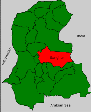
caption=Sanghar is located in the centre of Sindh.Sanghar District ( _ur. ضلع سانگھڑ) is one of the largest districts of
Sindh province,Pakistan . It is located in the centre of Sindh and is bounded to the east byIndia . The district capital,Sanghar , is itself a small city roughly 35 miles east-south-east of the city ofNawabshah and the same distance north ofMirpur Khas . Its primary industry is agriculture. According to the 1998 census of Pakistan, the district had a population of 1,453,028, of which 22.13% were located urban areas. [ [http://www.urckarachi.org/Population%20Table-5.htm Urban Resource Centre (1998 Census Figures)] ] .The following cities are located in Sanghar District:
Sanghar ,Tando Adam ,Jam Nawaz Ali ,Shahdadpur ,Shahpur Chakar ,Sinjhoro , andJhol , among others.Administration
The district is administratively subdivided into 6 talukas, these are: [ [http://www.lgdsindh.com.pk/sanghar2.htm DISTRICT GOVERNMENT - Sanghar] ]
*
Jam Nawaz Ali
*Khipro
*Sanghar
*Shahdadpur
*Sinjhoro
*Tando Adam History
The town of Sanghar, the district headquarters, was formerly a small village that has been populated since the 18th century. It was named after a pious fisherwoman, Mai Sanghar. For more than a century, it remained a small village with a population of few hundreds.
After the 1853 invasion by Charles Napier, Sindh was divided into provinces and was assigned
Zamindar s, also known as "Wadera ", to collect taxes for the British.Sindh was later made part of British India'sBombay Presidency , and became a separate province in 1935. During this period Sanghar obtained the status of Taluka, an administrative subdivision, and was alternatively included in districts of Nawabshah and Tharparkar. In 1954 it was given the status of District Headquarters.The people of the District, specifically the Hurs, played a vital role in independence of Pakistan. The Hurs were an organised military rebel group led by Pir Syed Sabghatullah Shah Pagaro shaheed, popularly known as
Pir Pagara , that sought independence from the British Raj (Colonist). They fought a gorilla warfare against the British military, and were always a thorn in the side of British Raj. It has been said that this warfare was one of the major nail in the coffin of British Raj in India.According to the legend the bodies of Sohni Mahiwal, the titular heroes of one of the four popular tragic romances of Sindh, were recovered from the river Indus near Shahdadpur city and are buried there. The Tomb of Sohni is situated in
Shahdadpur , which is 40 Km from Sanghar and 75 km from Hyderabad.Notable places
*
Mir Shahdad Jo Qubo , the tomb of Mir Shahdad Talpur, who is regarded as one of the finest military commanders of Sindh, is one of the historical heritages of Sindh and is located inShahpur Chakar , at a graveyard of the family members of Mir Shahdad Talpur. Shahdadpur, a big city of Sindh Province, is named after Mir Shahdad Talpur, while Shahpur Chakar is named behind his son Mir Chakar Talpur.
*Brahman Abad , ruins from the seventh cetury A.D. This site has been half-heartedly excavated by the government of Pakistan, and where the local folks go Gold-jewelry hunting after heavy rains. The rains wash off the top soil thereby exposing, among other artifcats, the ancient jewelry.ee also
*
Cadet College Sanghar one of the best institute
*Sohni Mahiwal Tomb of Sohni in Shahdadpur.
* Sanghar CityRerences
External links
* [http://www.lgdsindh.com.pk/sanghar2.htm District Government Sanghar]
* [http://orkut.com/Community.aspx?cmm=9050170 Sanghar Orkut Community]
* [http://www.maplandia.com/pakistan/sind/sanghar/ MAP ]

Wikimedia Foundation. 2010.