- Districts of Tajikistan
-
 Districts of Tajikistan
Tajikistan 
This article is part of the series:
Politics and government of
TajikistanGovernmentOthers- Political parties
- Human rights
- Foreign relations
- Provinces
- Districts
- Jamoats
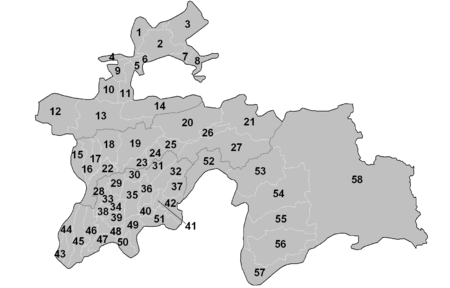
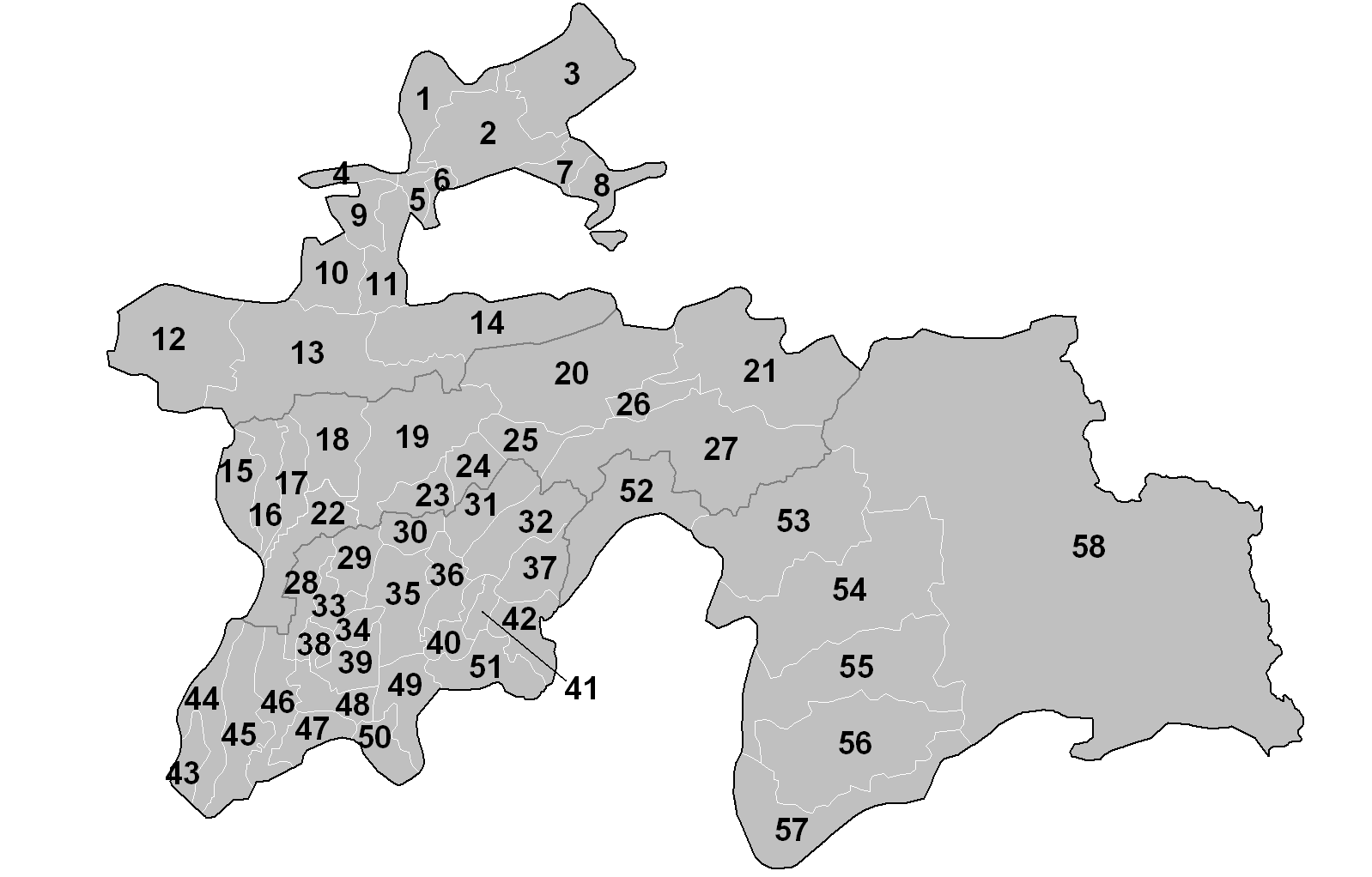
The provinces of Tajikistan are divided into 58 districts (Tajik: ноҳия, nohiya or Russian: район, raion).[1][2][3] The numbering of the districts follows the map.
Contents
Sughd Province
No. District Native name Former names Capital 1 Mastchoh Мастчоҳ Buston 2 Ghafurov Бобоҷон Ғафуров Leninabad, Khodzhent Ghafurov 3 Asht Ашт Shaydon 4 Zafarobod Зафаробод Zafarobod 5 Spitamen Нов Nau (until 2003)[4] Nov, Nau 6 Rasulov Ҷаббор Расулов Proletarsk Proletarsk 7 Konibodom Конибодом Konibodom 8 Isfara Исфара Isfara 9 Istarawshan Истаравшан Uroteppa (until 2000) Istaravshan 10 Shahriston Шаҳристон Shahriston 11 Ghonchi Ғончӣ Ghonchi 12 Panjakent Панҷакент Panjakent 13 Ayni Айнӣ Ayni 14 Kuhistoni Mastchoh Кӯҳистони Мастчоҳ Mehron Cities of provincial subordination: Chkalovsk, Isfara, Istaravshan, Qayraqqum, Khujand, Konibodom, Panjakent, Taboshar.
Raions of Republican Subordination
No. District Native name Former names Capital 15 Tursunzoda Турсунзода Regar (renamed between 1979 and 1989) Tursunzoda 16 Shahrinaw Шаҳринав Shahrinaw 17 Hisor Ҳисор Hisor 18 Varzob Варзоб Varzob 19 Vahdat Ваҳдат Yangibazar (1927-1936), Ordzhonikidzeabad
(1936-1992), Kofarnihon (1992-2003)[5]Vahdat 20 Rasht Рашт Gharm Gharm 21 Jirgatol Ҷиргатол Jirgatol[6] 22 Rudaki Рӯдакӣ Leninskiy (until 2003)[4][7] Somoniyon 23 Faizobod Файзобод Faizobod 24 Roghun Роғун Roghun 25 Nurobod Дарбанд Komsomolobod, Darband (until 2003)[8] Darband 26 Tojikobod Тоҷикобод Tojikobod 27 Tavildara Тавилдара Tavildara 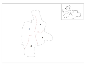
Cities of republican subordination: Dushanbe, Roghun, Tursunzoda, Vahdat.
City districts of Dushanbe
No. District Native name Former names 1 Ibn Sina Сино Frunze[4] 2 Firdavsi Фирдавсӣ Central[4] 3 Ismail Somoni Исмоили Сомонӣ Oktyabrskiy (October) 4 Shohmansur Шоҳмансур Zheleznodorozhnyi (Railway) Khatlon Province
No. District Native name Former names Capital 28 Khuroson Хуросон Ghozimalik[9] Obikiik 29 Yovon Ёвон Yovon 30 Norak Норак Norak 31 Baljuvon Балҷувон Baljuvon 32 Khovaling Ховалинг Khovaling 33 Jomi, Dzhami Абдураҳмони Ҷомӣ Kuybyshevsk, Khodzhamaston Kuybyshevsk 34 Sarband Сарбанд Sarband 35 Danghara Данғара Danghara 36 Temurmalik Темурмалик Qizil-Mazor (until 1957)[10],
Sovetskiy (until 2004)[11]Sovetskiy 37 Muminobod Мӯминобод Leningradskiy Leningradskiy 38 Bokhtar Бохтар Ismoili Somoni 39 Vakhsh Вахш Vakhsh 40 Vose Восеъ Vose 41 Kulob Кӯлоб Kulob 42 Shuroobod Шурообод Shuro-obod 43 Nosiri Khisrav Носири Хусрав Beshkent[12] Bahori 44 Shahrtuz Шаҳритус Shahrtuz 45 Qabodiyon Қубодиён Qabodiyon 46 Jilikul Ҷиликӯл Jilikul 47 Qumsangir Қумсангир Dusti 48 Rumi Колхозобод Kolkhozobod (until 23 June 2007)[13] Kolkhozobod 49 Farkhor Фархор Farkhor 50 Panj Панҷ Panj 51 Hamadoni Маскав Moskovskiy Moskovskiy Cities of provincial subordination: Kulob, Norak, Qurghonteppa, Sarband.
Gorno-Badakhshan Autonomous Province
No. District Native name Former names Capital 52 Darvoz Дарвоз Qala'i-Khumb Kalai-Khumb 53 Vanj Ванҷ Vanj 54 Rushon Рӯшон Rushon 55 Shughnon Шуғнон Khorugh 56 Roshtqala Роштқалъа Roshtqal'a 57 Ishkoshim Ишкошим Ishkoshim 58 Murghob Мурғоб Murghob City of provincial subordination: Khorugh.
References
- ^ Socio-Economic Atlas of Tajikistan, World Bank (2005)
- ^ Regions of the Republic of Tajikistan 2005, State Committee of Statistics, Dushanbe, 2005 (Russian)
- ^ Republic of Tajikistan, map showing administrative division as of January 1, 2004, "Tojjikoinot" Cartographic Press, Dushanbe (Russian)
- ^ a b c d Renaming Nau district to Spitamen district; Leninskiy district to Rudaki district; Frunze district to Sino district; Central district to Firdavsi district
- ^ Vahdat District
- ^ Presidential News, 4 October 2008 mentions Vahdat village as administrative capital of Jirgatol district; no verification could be obtained from other sources.
- ^ Rudaki District
- ^ Renaming Darband district to Nurobod district
- ^ Ghozimalik district renamed Khuroson district (Russian)
- ^ Qizil-Mazor (Kzyl-Mazar) district renamed Sovetskiy district, 1957 (Russian)
- ^ Sovetskiy district renamed Temurmalik district, 2004 (Russian)
- ^ Beshkent district renamed Nosiri Khisrav district, 2004 (Russian)
- ^ Kolkhozobod district renamed after Jaloliddin Rumi
Articles on second-level administrative divisions of Asian countries Afghanistan · Armenia2 · Bangladesh · Bhutan · Brunei · Burma · Cambodia · People's Republic of China · Cyprus1 · Egypt1 · Georgia1 · India · Indonesia · Iran · Iraq · Israel · Japan · Jordan · Kazakhstan1 · North Korea · South Korea · Kuwait · Kyrgyzstan · Laos · Lebanon · Malaysia · Mongolia · Nepal · Oman · Pakistan · Philippines · Russia1 · Saudi Arabia · Sri Lanka · Syria · Taiwan · Tajikistan · Thailand · Timor-Leste (East Timor) · Turkey1 · Turkmenistan · Uzbekistan · Vietnam · Yemen
1 Country spanning more than one continent (transcontinental country).
Table of administrative country subdivisions by country Categories:- Districts of Tajikistan
- Subdivisions of Tajikistan
- Lists of country subdivisions
- Country subdivisions of Asia
- Second-level administrative country subdivisions
- Tajikistan-related lists


Wikimedia Foundation. 2010.