- Mianwali
-
Mianwali, Pakistan
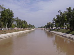
میانوالیThal Canal Coordinates: 32°21′N 71°20′E / 32.35°N 71.33°ECoordinates: 32°21′N 71°20′E / 32.35°N 71.33°E Country Pakistan Province Punjab District Mianwali District Government - Nazim Ubaidullah Khan Elevation 210 m (689 ft) Population - Total 110,359 (2,009 estimated) Time zone PST (UTC+5) Calling code (+92)0459 Punjab Government Website Mianwali (Urdu: میانوالی) is the capital city of Mianwali District and situated in the north-west of Punjab province, Pakistan. The city is located on the eastern bank of the Indus River. Thal canal traverses the city and makes the surroundings a picturesque place.
According to the 1998 census of Pakistan, the Mianwali city had a population of 85,000 inhabitants.[citation needed]
In November 1901, present day towns of Mianwali, Bhakkar, Isa Khel, Kalabagh, and Kundian were separated from Bannu District and hence a new district named as Mianwali District was created with the headquarters in Mianwali city. The municipal committee was founded in December 1903 and has remained operational since then.
Contents
Infrastructure
Mianwali city is the economic and commercial hub of the Mianwali district. The city has a FM Radio Station (FM 93), municipal library now called Professor Muhammad Feroz Shah Library, sports complex, and hockey stadium. There are several educational institutions from elementary to post-graduate level. .
The city has an airport built near the old World War II aerodrome and known as PAF Base Mianwali. It is one of the major operational bases of the country. The No.1 Fighter Conversion Unit of the PAF is stationed here.
There is also a railway connecting the city with Multan, Lahore and Rawalpindi.
The main highways connecting the city to the other parts of the country include the Sargodha–Lahore road [N–60], MM Road (Mianwali–Muzaffargarh road), Talagang–Rawalpindi road, and the Kalabagh–Bannu road [N–60].
History
Early history of the city is unknown. The city is famous for the shrine of Syed Mian Sultan Zakria, whose father Syed Mian Ali founded Mianwali village in the 16th century. The son is believed to have exhibited supernatural powers from an early age and many miraculous deeds are ascribed to him and his shrine is not uncommonly the scene of settlement of civil disputes.
Before the British rule, the area formed an integral portion of the Graeco–Bactrian Empire of Kabul and the Punjab.[1] During British rule, the Indian empire was subdivided into provinces, divisions and districts; afterward, the independence of Pakistan divisions remained the third tier of government until 2000. The British had made the town of Mianwali as tehsil headquarters of Bannu District then part of Dera Ismail Khan Division of Punjab province. The population of Mianwali, according to the 1901 census of India, was 3,591.[2]
In November 1901, the North-West Frontier Province was carved out of Punjab and the towns of Mianwali, Isa Khel, Kalabagh, and Kundian were separated from Bannu District (Bannu became part of NWFP) and hence a new district was made with the headquarters in Mianwali city and placed in Punjab. The district became a part of Multan Division. There were four tehsils namely Mianwali, Isa Khel, Bhakkar, and Layyah. Layyah was included in the Muzaffargarh District in 1909. The district became a part of Sargodha Division in 1961. Bhakkar Tehsil was carved out of Mianwali District and was made a separate district inside Sargodha Division w.e.f. 01-07-1982. Sawans is the One of famous UC of this district.
Languages and ethnicity
Saraiki language is widely spoken by the people of Mianwali while Urdu, Punjabi and Pashto languages are also spoken by Muhajir and by awans , Punjabi and Pushtun communities respectively.
Further reading
- "Gazetteer of the Mianwali district 1915" by Sang-e-Meel Publications, Lahore, Pakistan
- "Tareekh-e-Niazi Qabail"
- "Wichara Watan" By Harish Chander Nakra, New Delhi, India
- Henry George Raverty, Notes on Afghanistan and Baluchistan" (Indus Publications, Karachi)
See also
References
- A Glossary of the tribes & castes of Punjab by H. A Rose
External links
- http://mianwalinews.wordpress.com
- http://www.MianwaliOnline.com
- http://www.seraikigroup.nexo.com
 Chisholm, Hugh, ed (1911). "Mianwali". Encyclopædia Britannica (11th ed.). Cambridge University Press.
Major cities in Pakistan Islamabad Capital Territory Punjab Attock · Bahawalpur · Chakwal · Chiniot · Faisalabad · Gujar Khan · Gujranwala · Gujrat · Jhang · Jhelum · Kasur · Kharian · Lahore** · Mianwali · Multan · Murree · Rahim Yar Khan · Rawalpindi · Sadiqabad · Sahiwal · Sargodha · Sheikhupura · Sialkot · TaxilaSindh Khyber Pakhtunkhwa Balochistan Azad Kashmir Gilgit-Baltistan *Federal capital **Provincial/Territorial capitals Capital MianwaliTehsils Union councils Abbakhel · Alluwali · Ban Hafiz Jee · Chak No 7 ML AT Hafiz · Chakrala · Chapri · Chhidru · Dabb Balouchan · Daud Khel (Rural) · Daud Khel Urban (Town) · Dher Umid Ali Shah · Doaba · Gujrat · Gulmiri · Hernoli (Rural) · Hernoli Urban · Isakhel · Kalabagh · Kallur · Kamar Mushani · Kamar Mushani Pakka · Khaglan Wala · Khola At Khanqah Sirajia · Kot Chandna · Kundian -I · Kundian -Ii · Kundian Rural · Mari · Mianwali City -I · Mianwali City -Ii · Mianwali City -Iii · Mianwali City -Iv · Mochh · Musakhel · Muzafarpur Janubi · Muzafarpur Shumali · Namal · Paikhel · Piplan · Qureshian · Rokhri · Shadia · Shahbaz Khel · Sultan Khel · Swans · Tabisar · Tanikhel · Thamewali · Tibba Mehrban Shah · Tola Bhangi Khel · Trag · Vanjari · Vichvin Bala · Wan Bhachran · Watta Khel · Yaru KhelCategories:- Populated places in Mianwali District
Wikimedia Foundation. 2010.


