- Bagh District
Infobox Pakistan district
district = Bagh
area = 1,368
population = 434,000
pop_year = 2000
density = 324
caption =
region =Azad Kashmir
established = 1988
nazim =
naib_nazim =
seats =
tehsils = 3
languages =
website = www.apnabagh.com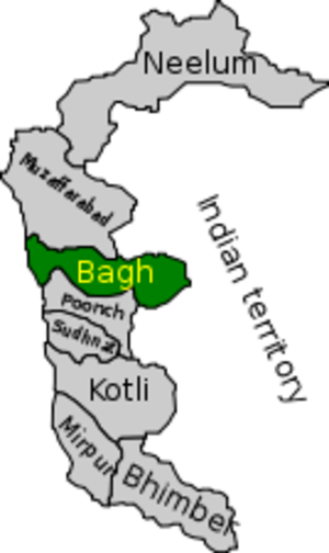
Bagh District is one of the eight districts of
Azad Kashmir ,Pakistan . The district, which had been part of Poonch District, was created in1988 [ [http://www.ajk.gov.pk/tourism/bagh.html Government of Azad Kashmir] ] . The district is bounded byMuzaffarabad District to the north, with Poonch district to the south, and withPoonch District of the Indian-administeredJammu and Kashmir to the east and is bounded toPunjab (Pakistan) in the west. The total area of the district is 1,368 square kilometers [ [http://www.ajk.gov.pk/site/index.php?option=com_content&task=view&id=2354&Itemid=138 Bagh District Statistics] ] . Bagh district is linked toMuzaffarabad by two roads, one viaSudhan Gali (80km) and the other through Kohala (97km). It is situated 46km fromRawalakot . The district is well known for its confectionery and bakery products.Demography
The total population of the district according to the 1998 census was 395,000 which is estimated to have increased to 434,000 in 2003, with an annual growth rate of 2% [ [http://www.pmajk.gov.pk/history.asp#info Population of Districts of Azad Jammu & Kashmir] ] . The people are mostly
Pahari 's andGujjars .Administration
The district is divided into 3
tehsil s:
*Bagh
*Dhirkot
*Havaily 2005 earthquake
The city of Bagh like other areas of the district was heavily damaged in the
2005 Kashmir earthquake . 60 percent of the buildings collapsed.Etymology
The word Bagh (باغ) comes from Persian and means garden. It is used in many toponyms such as the Kara-bagh (Black Garden) and Chaharbagh (Four Garden).
Notable areas of Bagh
*
Bagh - The district capital.
*Birpani - a union council 20km from Bagh, all the homes here were damaged or destroyed during the 2005 earthquake.
*Dhirkot - 25km from Bagh popular due to its high altitude.
*Ganga Choti
*Haveli
*Kalary Topy
*Mallot a town 17km away fromBagh city, like much of the district it was badly affected by the 2005 earthquake.
*Sesar
*Bees Bagla - one of places where a majority of people are Narma Rajpooth.
*Sudhan Gali village - located at 2134 near theGanga Choti mountains - was also badly affected by the earthquake and was one the areas thatUNICEF target for relief efforts.
*Munasa - a village which is 11 km from Kohala going toward Dhirkot. It is a beautiful place with good views of river Jehlam, Muzzafarabad, Ayubia, Bourbon, and Murree.
*Rehra Rera village is located about 10km from Bagh. It is a beautiful town located between two streams: seri kathi Mahal and Dullahi Mahal.Neela Butt
From Dhirkot towards southeast 6 km ahead, this spot is situated at an altitude of 2000 meters. Besides its scenic beauty, this place is well-known for its historic background. On August 23, 1947 the Mujahideen-e-Azadi assembled at this place and started armed struggle for accession to Pakistan . Sufficient accommodation facilities are available here for visitors. Neela Butt is the place from where a young aged person belonging to
Dhond Abbasi tribe took up his arms against theDogra Raj, titled as Mujahid e Awwal Sardar Abdul Qayyum Khan . His heroic effort was a shot in arm for the whole of the Poonch District. His son named as Sardar Attique Ahmed Khan now heads the AJK government.Neela But has another significance in the history. In 1995 Mian Nawaz Sharif the ex Prime Minister of Pakistan and Leader of opposition visited the Neela But on 23 of August 1997 and during his speech he made an announcement that Pakistan has made the Nuclear Bomb.This waw a very critical statement by an ex prime minister and leader of opposition. There was an uproar in the media. Some people said that Nawaz Sharif has disclosed a national secret. But Later in May 28 1998 when Pakistan made six nuclear test it was proven that what Nawaz Sharif has said in Neela But was true it is a great land mark in the history of Azad Kashmir and Pakistan.
Las Danna
From Bagh, a 15 kilometres long metalled road leads to Las Danna which is a place of captivating scenes and natural beauty. From Lasdanna, three roads branch off the main road i.e. Mahmood gali-Palangi, Haji pir- Aliabad and Abbasspur- Hajira respectively. A tourist rest house is available here for accommodation.Pass Jhola a village of district bagh connected with Bees Bagla.it is a small village. it is in the north of Bees Bagla.two Roads one in the middle of Pas Jhola joining It with Gania Abad, and Other is passing side by side with Pas Jhola.
Bees Bagla is the center Place Of Pas Jhola.
References
ee also
*
Bagh (town)
*Azad Kashmir
*Pakistan External links
* [http://www.kashmirearthquake.com Kashmir Earthquake]
* [http://www.kashmir.kct-uk.org Azad Kashmir]

Wikimedia Foundation. 2010.