- Mirpur Khas
-
Mirpur Khas 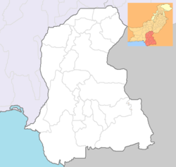
 Mirpur Khas
Coordinates: 25°19′N 69°00′E / 25.31°N 69.00°ECoordinates: 25°19′N 69°00′E / 25.31°N 69.00°E Country  Pakistan
Province  Sindh
SindhPopulation – Estimate (2008) 374,371 Time zone PST (UTC+5) Calling code 0233 Number of towns 5 Mirpur Khas (Sindhi: میرپور خاص) (Urdu: میرپور خاص) is a city in the province of Sindh in Pakistan. It is the fifth largest city in the province with an estimated population of 488,590 (2009). Its soil is fertile and the city is known for its horticultural produce and farming, as well as mango cultivation, with hundreds of varieties of mangoes produced each year.
Contents
History
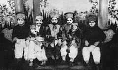 The Talpur Princes of Mirpurkhas: Third from the left is Mir Ali Murad Talpur II, the great grandson of Mir Ali Murad Talpur, the founder of Mirpur Khas
Prior to the Islamic conquest of Sindh by the Arabian armies of Muhammad Bin Qasim, the land where Mirpur Khas now stands used to be a thriving Buddhist settlement known as Kahoo Jo Daro. The remnant stupa still remains and as the armies settled in the area, newer buildings occupied the land and led into massively progressive landscapes. Farming became known to people and horticulture and cotton fields blossomed.[1]
In 1806, Mankani Talpurs shifted their capital from Keti Mir Tharo and laid foundations for Mirpur Khas under the leadership of Mir Ali Murad Talpur. Mir Sher Muhammad Talpur succeeded Mir Ali Murad and built a fort when declared the ruler of the state. He would run a kutchery from within the fort. Mirpurkhas remained capital of Talpur Mirs of Mirpurkhas until 1843 when Sindh was annexed to British India under East India Company. When Charles James Napier attacked Sindh, Mir Sher Muhammad Talpur was the last Talpur ruler to face the British[2] on 24 March 1843 at the battleground of Dubbo. His battle for the liberation of Sindh has rendered him the title of 'the lion of Sindh'. The kutchery in the fort now has a tablet embedded at the entrance reading, "The fort within which this building stands was residence of Mir Sher Muhammad Khan, the Lion of Sind."
Later Sindh was made part of Bombay Presidency and Mirpurkhas was a part of it. Umerkot was made the district's head-quarter town and Mirpur Khas was ignored until the advent of the Luni-Hyderabad branch of the Jodhpur-Bikaner Railway,[2] a subsidiary of the Scinde Railway to the town. The opening of the Jamrao Canal in 1900 made Mirpur Khas stand out of the rest of the towns in the district. It was constituted a municipality in 1901[2] and was made the district head-quarter in 1906.
At the turn of the twentieth century, the population of the town was 2,787 with a density of 82 persons per square mile, however the district, as a whole, saw significant growth in the rise of population from 27,866 (1891) to 37,273 (1901). The cotton produced at Mirpur Khas was considered the best in the country when surveyed and the British exploited the produce by exporting it to other nations.[2]
After the partition, because of its proximity with the Indian border, Mirpur Khas became the first city to welcome refugees from the newly found Indian nation to Pakistan. It acted as a primary railway junction for the first trains to rail across the Rajistan to the Sindh province.
Geography
Lying on the Let Wah Canal at 25°31′39.3″N 69°00′50.6″E / 25.527583°N 69.014056°E, Mirpur Khas is the gateway to the south-eastern edge of the Sindh province. It connects to Hyderabad at 65-kilometres by both road and rail while with Umerkot it connects only by road. Karachi is 220-kilometres south-west of the town. On the extreme east lies the Indian border at 170-kilometres.
Mirpur Khas is positioned atop a fertile land making conditions apt for farming and irrigation. Being connected to the Indus via irrigation canals like the Let Wah, Mirpur Khas has gained an advantage in horticulture and farming over the years. Primary produce includes mangoes (famous for producing mangoes), sugarcane and cotton, wheat, & chillies. Bananas are also widely cultivated around the region and also one of the biggest producer of Bananas in the country.
Education
The city has three government colleges: Shah Abdul Latif Government Science College for Boys, Ibne-Rushd Government Degree College for women and Model College of Arts Education, all affiliated with the University of Sindh. Of the Higher Secondary Education Institutions, Government Shah-wali-Allah Higher secondary school, Government Model High School, Government Comprehensive Higher Secondary School for Boys, Government High School for boys and government High School for Girls, Government Higher Secondary School for Boys Bhansinghabad, and Government Higher Secondary School for Girls Bhansinghabad are actively running in the city.
Mirpurkhas also has a Sindh University Campus that have five(5) Departments:
1:- BS-Information Technology
2:- BS-Computer Science
3:- BS-Commerce
4:- BBA
5:- BS-Geology
Mirpur Khas city also has a medical college (Muhammad Medical College) affailated with Sindh Medical University, a number of Science & Technology institutes like MIST and CMS affailated with University of Sindh and with an own Board of Intermediate and Secondary Education.
The Eastern Public School and College is another institute affiliated from AKU-EB board karachi and also with BISE Mirpurkhas.
The City has two very well maintained and up to-date public libraries run by the provincial government, Municipal Library and Allama Iqbal Public Library.
Plans are underway to set up a full-fledged Medical College and a campus of University of Sindh in public sector.
The City has well built and sufficiently equipped Civil Hospital with a state-of-the-art heart disease Center. The hospital, being a (previously) divisional headquarter, caters to a huge number of patients from various parts of the suburb. Apart from the Civil Hospital, there are a number of private health establishments working day and night to cater to the general public needs. Some of them are, Ahmadani clinic, Ali MediCare Center, Maria Medical Complex, Alshifa Hospital Dr. Naseem Memorial Hospital & Dr. Nazir memorial hospital which are providing free services to the neglected class of this society.Mirpurkhas deadly needs a well equipped hospital and other investigative facilities,unfortunately since doctors started taken this profession as business there has nothing left to say to communicate the feeling of this Regions's people.
Culture and economy
The city has several shopping centers and bazaars which includes, Baldia Shopping Center, Shahi Bazaar and Khisakpura Rasheed Ahmed Siddiqui Shopping Arcade Khipro Stand & Irshad Ahmed Siddiqui Shopping Strip (in local slang), which sells traditional garments, modern crockery, etc.
Irrigation and farming was revitalised after the Jamrao Canal was built in the 1900s. The city was able to produce and cycle crops to supply mainly grain, cotton products like fabrics, and sugar from the sugarcane cultivations. For a certain period in history, Mirpurkhas enjoyed being the best cotton producer in the country and much of the income of the town came from cotton farming in its heyday. In late 18th century, many Muslim families were shifted from east Punjab to the area. Their contribution to the agriculture and irrigation systems is remarkable. They live mostly in rural areas with peace and harmony.
Nowadays, however, The area is much known its mango produce. The city seeks pleasure in declaring having 250 different varieties of "mangoes", of which the most famous variety is the *Sindhri Amb* literally the mango from Sindh. The city boasts its mango products at an annual harvest festival showcasing its world-renowned produce.
The district has very fertile land and it produces wheat, onion, suagrcane, cotton, corn, mangoes and other crops. Though Mirpurkhas has small industrial park but no industry is functional over there. However, there are four sugar mills, namely Mirpurkhas sugar mills, Mirawah sugar mills, Digri SUgar Mills. and Najma sugar mills, of them Mirpurkhas sugar mills is the oldest one.
Transport
Mirpurkhas Railway Station is in middle of city. After 40 years a railway link between Pakistan and India is being opened again. A broad gauge line has been laid from Mirpur Khas to Khokra Par, which is the border town from Pakistani Side. The new link now connects Karachi (Pakistan) to Jodhpur (India) by the new train service Thar Express. In 2005, work started on converting the metre gauge railway line to Khokhrapar to broad gauge. Mirpurkhas Railway Station has one of the longest plateforms in Pakistan.
Religion
- Muslims: 89.00%
- Hindus: 9.71%
- Christians: 0.90%
- Ahmadis: 0.27%
- Others: 0.12%
See also
- Chitorri, a historical graveyard with many sandstone tombs of Talpur rulers
- Kahu-Jo-Darro, an ancient Buddhist archaeological site
References
- ^ "Archaeological heritage situation in Sindh". World Sindhi Congress. http://world-sindhi-congress.org/index.php?content=archeology. Retrieved 2008-05-25.
- ^ a b c d Hunter, William Wilson, Sir. Imperial Gazetteer of India. volume 17. Clarendon Press (Oxford, 1908-1931). p. 365. http://dsal.uchicago.edu/reference/gazetteer/pager.html?objectid=DS405.1.I34_V17_371.gif. Retrieved 2008-05-25.
Categories:- Populated places in Sindh
- Pre-Islamic heritage of Pakistan


Wikimedia Foundation. 2010.