- Muzaffarabad District
-
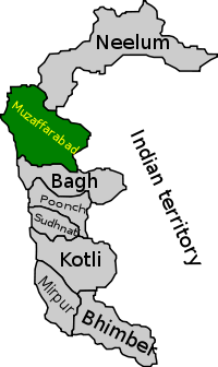
Muzaffarabad — Districts of Azad Kashmir — Map of Azad Kashmir with Muzaffarabad highlighted Country  Azad Kashmir
Capital Muzaffarabad Established Government - District Nazim - District Naib Nazim Time zone PST (UTC+5) District Council Number of Tehsils 3 Muzaffarabad district (Pahari: مُظفٌر آباد ضلع) of Azad Kashmir is located on the banks of the Jhelum and the Neelum rivers, and is very hilly. The district is bounded to Pakistan in the west and to Kupwara and Baramulla districts that comes under the Kashmir section which is part of the greater dispute between India and Pakistan. To the north is Neelum District; the fall on the northeast of the district and Bagh District forms the southern boundary. The total area of the district is 6,117 square kilometres. The city of Muzaffarabad serves as capital of Azad Jammu and Kashmir.
It was part of Muzaffarabad Division.
Contents
Demography
The total population of the district according to the 1998 census was 725,000 and according to the 1999 projection its population stands at 741,000.
Subdivisions
The district is administratively subdivided into three tehsils and fifty one Union Councils[1]
References
External links
Divisions Muzaffarabad · Mirpur · Rawalakot
Districts Categories:- Muzaffarabad District
- Districts of Azad Kashmir
- Azad Kashmir geography stubs
Wikimedia Foundation. 2010.

