- Rural City of Mildura
-
Rural City of Mildura
Victoria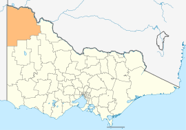
Location in VictoriaPopulation: 53,877(2009)[1] Mayor: Glenn Milne 
LGAs around Rural City of Mildura: Renmark Paringa (SA) Wentworth (NSW) Wentworth (NSW) Loxton Waikerie (SA) Rural City of Mildura Swan Hill Southern Mallee (SA) Hindmarsh Yarriambiack The Rural City of Mildura is a Local Government Area in Victoria, Australia. It is located in the north-western part of the state. It has an area of 22,214 square kilometres. Localities within the LGA include Mildura city itself and the towns of Merbein, Red Cliffs, Irymple, Ouyen, Werrimull, Murrayville, Walpeup, and Hattah. It was formed in 1995 from a merger of the City of Mildura, Shire of Mildura and Shire of Walpeup.
The Rural City of Mildura covers most of the Mallee region of Victoria. Before the less infertile soils were fertilised and developed for the production of wheat and barley the whole region was covered in a dense mallee scrub of deep-rooting eucalypts that regenerated after the frequent bushfires in the region. Many of the soils are so sandy that clearing is impractical, and Murray-Sunset National Park covers almost a third of the area of the LGA. Other protected areas include Hattah-Kulkyne National Park and Murray-Kulkyne Park on the Murray River.
The climate of the region is the driest in Victoria, and Neds Corner in the remote northwest has the lowest average annual rainfall in the State at 240 millimetres (9.5 inches). In the south at Ouyen the average is 335 millimetres (13.5 inches). In all areas there can be considerable variation in annual rainfall: the range historically has been from 110 millimetres (4.5 inches) in 1967 to 605 millimetres (23.8 inches) in 1973. Temperatures are the hottest in Victoria and in summer maxima average 32°C (90°F) but often exceed 40°C (104°F). The winter is very pleasant with maxima of 16°C (60°F), but frosts are common in the morning and sometimes severe.
The southeast of the LGA is used primarily for grain growing; however yield are erratic and often poor due to drought. In the north irrigated fruit (primarily oranges and grapes) growing is a huge earner of money and supports Mildura and nearby towns; however, salinity in the Murray River is a major threat to the long-term sustainability of these activities, as is competition from overseas citrus growers.
In 2006 the Rural City of Mildura had a population of 49,815, most of which was located in Mildura (30,016) and adjacent areas (that is Victorian Sunraysia). Many of the small towns in the region have practically disappeared as more efficient farming methods reduce the quantity of human labour required.
The council is composed of nine councillors elected to represent an unsubdivided municipality.[2]
Contents
Sister cities
Mildura has sister city relations with the following cities[3]:
 Dali, Yunnan Province of China
 Kumatori, Japan
 Upland, California, United States of America
See also
References
- ^ Australian Bureau of Statistics (30 March 2010). "Regional Population Growth, Australia, 2008–09". http://www.abs.gov.au/ausstats/abs@.nsf/Latestproducts/3218.0Main%20Features52008-09?opendocument&tabname=Summary&prodno=3218.0&issue=2008-09&num=&view=. Retrieved 3 June 2010.
- ^ Local Government Victoria. "Mildura Rural City Council". http://www.localgovernment.vic.gov.au/web20/dvclgv.nsf/AllDocs/27EC5AE7DF0CFECCCA2571610027AEC2?OpenDocument. Retrieved 2008-10-30
- ^ Mildura Sister Cities
External links
- Mildura Rural City Council
- Metlink local public transport map
- Link to Land Victoria interactive maps
Towns in the Rural City of Mildura Big Desert • Birdwoodton • Boinka • Cabarita • Cardross • Carina • Carwarp • Colignan • Cowangie • Cullulleraine • Hattah • Iraak • Irymple • Koorlong • Kulwin • Lindsay Point • Linga • Merbein • Merbein South • Merbein West • Meringur • Merrinee • Mildura • Mittyack • Murrayville • Nangiloc • Neds Corner • Nichols Point • Ouyen • Panitya • Patchewollock • Red Cliffs • Tempy • Torrita • Tutye • Underbool • Walpeup • Wargan • Werrimull • Yelta •
Local Government Areas of Victoria Greater Melbourne Inner MelbourneMetropolitanBanyule · Bayside · Boroondara · Darebin · Glen Eira · Hobsons Bay · Kingston · Maribyrnong · Maroondah · Monash · Moonee Valley · Moreland · WhitehorseOuter MetropolitanBrimbank · Cardinia · Casey · Frankston · Greater Dandenong · Hume · Knox · Manningham · Melton · Mornington Peninsula · Nillumbik · Whittlesea · Wyndham · Yarra RangesSouthwest Central Highlands and Goldfields Goulburn Valley Northeast Gippsland Western District Wimmera The Mallee Categories:- Local Government Areas of Victoria (Australia)
- Mildura

Wikimedia Foundation. 2010.