- Shire of Mansfield
-
Shire of Mansfield
Victoria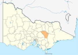
Location in VictoriaPopulation: 7,881(2009)[1] Area: 3892 km² (1,502.7 sq mi) Mayor: Cr Tom Ingpen Council Seat: Mansfield LGAs around Shire of Mansfield: Strathbogie Benalla Wangaratta Murrindindi Shire of Mansfield East Gippsland Yarra Ranges Baw Baw Wellington This article is about a current local government area created in 2002. For the local government area prior to 1994, see Shire of Mansfield (former).The Shire of Mansfield is a Local Government Area in Victoria, Australia. It is located in the north-eastern part of the state. It includes the towns of Mansfield, Mount Buller, Bonnie Doon, Jamieson, Kevington, Merrijig and Woods Point. In 2006 it had a population of 7,191.
The shire is bordered by the Rural City of Benalla, the Shire of Baw Baw, the Shire of Murrindindi, the Shire of Yarra Ranges, the Shire of Strathbogie and the Shire of Wellington. There is one unincorporated area within the shire; the area around Mount Buller. The current Shire was formed from the 2002 demerger of the Shire of Delatite.
Contents
Wards
- Bonnie Doon
- Jamieson
- Mansfield
- Tolmie
Mansfield ward is represented by two elected Councillors, the others by one elected Councillor. [2]
See also
References
- ^ Australian Bureau of Statistics (30 March 2010). "Regional Population Growth, Australia, 2008–09". http://www.abs.gov.au/ausstats/abs@.nsf/Latestproducts/3218.0Main%20Features52008-09?opendocument&tabname=Summary&prodno=3218.0&issue=2008-09&num=&view=. Retrieved 3 June 2010.
- ^ Local Government Victoria. "Mansfield Shire Council". http://www.localgovernment.vic.gov.au/web20/dvclgv.nsf/AllDocs/E66CE60796EA20A7CA25716100270782?OpenDocument. Retrieved 2008-10-30
External links
- Mansfield Shire Council official website
- Metlink local public transport map
- Link to Land Victoria interactive maps
Towns in the Shire of Mansfield A1 Mine Settlement • Ancona • Bonnie Doon • Gaffneys Creek • Goughs Bay • Howqua • Jamieson • Kevington • Macs Cove • Maindample • Mansfield • Matlock • Merrijig • Merton • Mount Buller • Sawmill Settlement • Tolmie • Woods Point •
Local Government Areas of Victoria Greater Melbourne Inner MelbourneMetropolitanBanyule · Bayside · Boroondara · Darebin · Glen Eira · Hobsons Bay · Kingston · Maribyrnong · Maroondah · Monash · Moonee Valley · Moreland · WhitehorseOuter MetropolitanBrimbank · Cardinia · Casey · Frankston · Greater Dandenong · Hume · Knox · Manningham · Melton · Mornington Peninsula · Nillumbik · Whittlesea · Wyndham · Yarra RangesSouthwest Central Highlands and Goldfields Goulburn Valley Northeast Gippsland Western District Wimmera The Mallee Coordinates: 37°03′00″S 146°05′00″E / 37.05°S 146.0833333°E
Categories:- Local Government Areas of Victoria (Australia)
- Australia government stubs

Wikimedia Foundation. 2010.