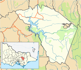
- Merrijig, Victoria
-
Merrijig
VictoriaPopulation: 697[1] Postcode: 3723 Location: - 201 km (125 mi) NE of Melbourne
- 19 km (12 mi) E of Mansfield
- 71 km (44 mi) NW of Mount Buller
LGA: Shire of Mansfield State District: Benalla Federal Division: Indi Merrijig is a town in Victoria, Australia, located between Mount Buller and Mansfield. At the 2006 census, Merrijig and the surrounding area had a population of 697.[1] A second town in Victoria named "Merrijig" exists in East Gippsland.
The first Merrijig Post Office opened on 4 October 1866 and was replaced by Boggy Creek in 1867. Another Merrijig Post Office opened on 1 April 1866 (known as Delatite from 1872 until 1924) and closed in 1970.[2]
References
- ^ a b Australian Bureau of Statistics (25 October 2007). "Merrijig (Mount Buller) (State Suburb)". 2006 Census QuickStats. http://www.censusdata.abs.gov.au/ABSNavigation/prenav/LocationSearch?collection=Census&period=2006&areacode=SSC26153&producttype=QuickStats&breadcrumb=PL&action=401. Retrieved 2007-08-05.
- ^ Premier Postal History, Post Office List, https://www.premierpostal.com/cgi-bin/wsProd.sh/Viewpocdwrapper.p?SortBy=VIC&country=, retrieved 2008-04-11
Coordinates: 37°06′S 146°15′E / 37.1°S 146.25°E
Towns in the Shire of Mansfield A1 Mine Settlement • Ancona • Bonnie Doon • Gaffneys Creek • Goughs Bay • Howqua • Jamieson • Kevington • Macs Cove • Maindample • Mansfield • Matlock • Merrijig • Merton • Mount Buller • Sawmill Settlement • Tolmie • Woods Point •
Categories:- Towns in Victoria (Australia)
- Victoria (Australia) geography stubs
Wikimedia Foundation. 2010.

