- Maindample
-
Maindample
Victoria
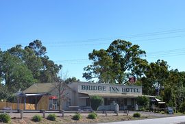
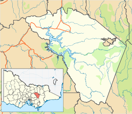
The Bridge Inn Hotel, burnt down in 2010Postcode: 3723 Coordinates: 37°02′S 145°56′E / 37.033°S 145.933°ECoordinates: 37°02′S 145°56′E / 37.033°S 145.933°E Location: - 174 km (108 mi) NE of Melbourne
- 14 km (9 mi) W of Mansfield
- 7 km (4 mi) E of Bonnie Doon
LGA: Shire of Mansfield State District: Benalla Federal Division: Indi Maindample is a town in north east Victoria. The town is located in the Mansfield Shire local government area, 174 kilometres (108 mi) north east of the state capital Melbourne.
The Bridge Inn Hotel, a popular stop over for travellers to the Victorian ski fields, burned down in 2010.[1]
References
- ^ "Maindample pub destroyed by fire". Weekly Times. 28 July 2010. http://www.weeklytimesnow.com.au/article/2010/07/28/215065_latest-news.html. Retrieved 17 August 2010.
See also
- Maindample railway station, Victoria
Further reading
- Hutchinson, Shiela (2008). Maindample district : the early days -- beginning in the 1860's / researched and compiled by Sheila Hutchinson. Maindample: S. Hutchinson.
Towns in the Shire of Mansfield A1 Mine Settlement • Ancona • Bonnie Doon • Gaffneys Creek • Goughs Bay • Howqua • Jamieson • Kevington • Macs Cove • Maindample • Mansfield • Matlock • Merrijig • Merton • Mount Buller • Sawmill Settlement • Tolmie • Woods Point •
Categories:- Towns in Victoria (Australia)
- Victoria (Australia) geography stubs
Wikimedia Foundation. 2010.


