- Shire of Northern Grampians
-
Shire of Northern Grampians
Victoria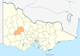
Location in VictoriaPopulation: 12,340(2009)[1] Area: 5918 km² (2,285.0 sq mi) Mayor: Bryan Small Council Seat: Stawell Region: Grampians 
LGAs around Shire of Northern Grampians: Yarriambiack Buloke Loddon Horsham Shire of Northern Grampians Central Goldfields Southern Grampians Ararat Pyrenees The Shire of Northern Grampians is a Local Government Area in the Wimmera region of Victoria, Australia. It is located in the western part of the state. It includes the towns of Halls Gap, St Arnaud and Stawell, and the main townships of Great Western, Marnoo, Glenorchy, Stuart Mill and Navarre. It has an area of 5,918 square kilometres. In 2006, it had a population of 11,912. It was formed in 1995 from the merger of the City of Stawell, Town of St Arnaud, Shire of Stawell, Shire of Kara Kara and parts of the Shire of Wimmera, Shire of Dunmunkle and Shire of Donald.
The local economy is based on a diverse range of industries including agriculture, tourism, wine production, gold mining.
Contents
Wards
- Central
- Kara Kara, named after the County of Kara Kara
- South West
- Stawell[2]
See also
References
- ^ Australian Bureau of Statistics (30 March 2010). "Regional Population Growth, Australia, 2008–09". http://www.abs.gov.au/ausstats/abs@.nsf/Latestproducts/3218.0Main%20Features52008-09?opendocument&tabname=Summary&prodno=3218.0&issue=2008-09&num=&view=. Retrieved 3 June 2010.
- ^ Local Government Victoria. "Shire of Northern Grampians Shire Council". http://www.localgovernment.vic.gov.au/web20/dvclgv.nsf/AllDocs/226775F9DAC69E1BCA2571610029A00C?OpenDocument. Retrieved 2008-10-30
External links
- Northern Grampians Shire Council official website
- Metlink local public transport map
- Link to Land Victoria interactive maps
Towns in the Shire of Northern Grampians Local Government Areas of Victoria Greater Melbourne Inner MelbourneMetropolitanBanyule · Bayside · Boroondara · Darebin · Glen Eira · Hobsons Bay · Kingston · Maribyrnong · Maroondah · Monash · Moonee Valley · Moreland · WhitehorseOuter MetropolitanBrimbank · Cardinia · Casey · Frankston · Greater Dandenong · Hume · Knox · Manningham · Melton · Mornington Peninsula · Nillumbik · Whittlesea · Wyndham · Yarra RangesSouthwest Central Highlands and Goldfields Goulburn Valley Northeast Gippsland Western District Wimmera The Mallee Coordinates: 36°39′00″S 143°01′00″E / 36.65°S 143.0166667°E
Categories:- Local Government Areas of Victoria (Australia)
- Wimmera
- Australia government stubs

Wikimedia Foundation. 2010.