- City of Banyule
-
City of Banyule
Victoria
Map of Melbourne showing BanyulePopulation: 123,521(2009)[1] Established: 1994 Area: 63 km² (24.3 sq mi) Mayor: Wayne Phillips Council Seat: Ivanhoe State District: Ivanhoe, Bundoora, Eltham Federal Division: Jagajaga 
LGAs around City of Banyule: Whittlesea Nillumbik Nillumbik Darebin City of Banyule Nillumbik Yarra Boroondara Manningham The City of Banyule is a Local Government Area in Victoria, Australia, located in the north-eastern suburbs of Melbourne. It has an area of 63 square kilometres (24.3 sq mi) and lies between 7 and 21 km from central Melbourne. The Yarra River runs along the City’s south border while the west is defined by Darebin Creek.
At the 2006 census, it had a population of 114,866. The area was originally occupied by the Wurundjeri, Indigenous Australians of the Kulin nation, who spoke variations of the Woiwurrung language group.
The City was named after the Indigenous Australian term Banyule or "Banyool", and was originally the name of a locality within the former City of Heidelberg before being adopted as the name of the new council during the amalgamation of local government areas in Victoria. It was formed in 1994 from the merger of the City of Heidelberg with parts of the Shire of Diamond Valley and Shire of Eltham.
The City also has some remarkably significant heritage within its boundaries, including a number of housing estates designed by leading early 20th Century architects Walter Burley Griffin and Albert Victor Jennings, some of the most significant art deco buildings in Melbourne and the world's first Olympic athletes village.
Banyule is the birth place of the internationally recognised Heidelberg School of Art, which was formed when a group of iconic artists, including Tom Roberts, Arthur Streeton, Frederick McCubbin, Walter Withers, Charles Conder and others moved to a shack on Mount Eagle (now known as Eaglemont) and began painting the landscape in a uniquely Australian way during the late 1880s.
Contents
Wards and Councillors
The current councillors of the city after the elections in November 2008 are:
- Bakewell Ward: named after brothers who established the Plenty Station
Peter McKenna (current Mayor)
- Beale Ward: named after Major Edward Beale who, amongst other contributors, founded St Katherines church at St Helena
Wayne Philips
- Griffin Ward: named after Walter Burley Griffin who planned estates in the area
Jenny Mulholland
- Grimshaw Ward: named after an early contributor to public life
Jessica Paul
- Hawdon Ward: named after Joseph Hawdon who built the Banyule Homestead
Steven Briffa
- Ibbott Ward: named after Nellie Ibbott, Mayor of the City of Heidelberg and the first woman mayor in Victoria
Tom Melican
- Olympia Ward: named after the area of the Melbourne Olympic Games Village in 1956
Anthony Carbines
Suburbs
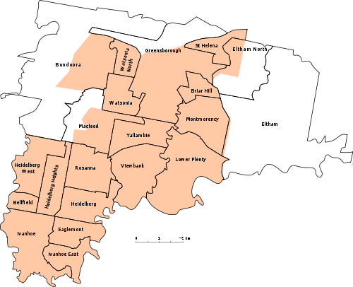

- Bellfield
- Bundoora
- Briar Hill
- Eaglemont
- Eltham North (Shared With Nillumbik Shire
- Greensborough
- Heidelberg
- Heidelberg Heights
- Heidelberg West
- Ivanhoe
- Ivanhoe East
- Lower Plenty
- Macleod (Shared With City of Darebin)
- Montmorency
- Rosanna
- Viewbank
- Watsonia
- Watsonia North
- Yallambie
Notable people
See also
References
- ^ Australian Bureau of Statistics (30 March 2010). "Regional Population Growth, Australia, 2008–09` - Victoria". http://www.abs.gov.au/ausstats/abs@.nsf/Products/3218.0~2008-09~Main+Features~Victoria?OpenDocument. Retrieved 3 May 2010.
External links
- Official website
- Yarra Plenty Library
- Metlink local public transport map
- Link to Land Victoria interactive maps
Local Government Areas of Victoria Greater Melbourne Inner MelbourneMetropolitanBanyule · Bayside · Boroondara · Darebin · Glen Eira · Hobsons Bay · Kingston · Maribyrnong · Maroondah · Monash · Moonee Valley · Moreland · WhitehorseOuter MetropolitanBrimbank · Cardinia · Casey · Frankston · Greater Dandenong · Hume · Knox · Manningham · Melton · Mornington Peninsula · Nillumbik · Whittlesea · Wyndham · Yarra RangesSouthwest Central Highlands and Goldfields Goulburn Valley Northeast Gippsland Western District Wimmera The Mallee Coordinates: 37°44′00″S 145°05′00″E / 37.7333333°S 145.0833333°E
Categories:- Populated places established in 1994
- 1994 establishments in Australia
- Local Government Areas in Melbourne

Wikimedia Foundation. 2010.