- Shire of Eltham
Infobox Australian Place | type = lga
name = Shire of Eltham
state = vic
region = NEMelbourne
area = 277.13
est = 1856
seat = Eltham
pop = 44,800 (1992) [cite book|title=Victorian Year Book|author=Australian Bureau of Statistics, Victoria Office|year=1994|page=49|id=ISSN 0067-1223]
logosize =
imagesize = 150
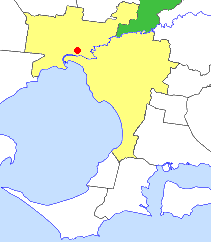
caption = Location in outer Melbourne
county = Evelyn
near-nw = Whittlesea
near-n = Yea
near-ne = Yea
near-w = Diamond Valley
near-e = Healesville
near-sw = Heidelberg
near-s = Doncaster & Templestowe
near-se = Lillydale
_noautocat = yesThe Shire of Eltham was a Local Government Area located about convert|25|km|mi|0 northeast of
Melbourne , the state capital of Victoria,Australia . The shire covered an area of convert|277.13|km2|sqmi|1, and existed from 1856 until 1994.History
Eltham was first incorporated as a district on 26 September 1856, and became a shire on 6 April 1871. In 1912 it lost some of its area to the
Shire of Healesville .On 18 June 1958, it lost its convert|218|km2|sqmi|1|sing=on|abbr=on East Riding to
Shire of Healesville . This area comprised Yarra Glen, Dixons Creek and parts of Christmas Hills.cite web|url=http://www.arts.monash.edu.au/ncas/multimedia/gazetteer/list/eltham.html|title=Australian Places - Eltham|author=Monash University |year=1999|accessdate=2008-01-05] It also lost part of North Riding near Kinglake to theShire of Yea on 1 October 1972.cite book|title=Victorian Municipal Directory|year=1992|publisher=Arnall & Jackson|location=Brunswick|pages=666-667 Accessed atState Library of Victoria , La Trobe Reading Room.]On 15 December 1994, the Shire was abolished. The Kinglake district were transferred to the new
Shire of Murrindindi , while Montmorency and Lower Plenty in the shire's far southwest were transferred toCity of Banyule . The rest became part of the newShire of Nillumbik . [cite book|url=http://www.ausstats.abs.gov.au/ausstats/free.nsf/0/76E601D6DB55E88ACA25722500049195/$File/12570_1994-95.pdf|title=Victorian local government amalgamations 1994-1995: Changes to the Australian Standard Geographical Classification|author=Australian Bureau of Statistics |date=1 August 1995|publisher=Commonwealth of Australia|page=4,10|isbn=0-642-23117-6|accessdate=2007-12-16]Wards
The shire was divided into three ridings on 16 March 1955, each of which elected three councillors:
* Central Riding
* North Riding
* West Ridinguburbs and Localities
* Briar Hill (split with
Shire of Diamond Valley )
* Christmas Hills (split withShire of Healesville )
* Cottles Bridge
* Eltham
* Greensborough (split withShire of Diamond Valley )
* Hurstbridge (split withCity of Whittlesea andShire of Diamond Valley )
* Kangaroo Ground
* Kinglake (split withShire of Yea )
* Lower Plenty
* Montmorency
* Panton Hill
* Research
* Smiths Gully
* St Andrews
* Strathewen
* Warrandyte North
* Watsons Creek
* Wattle Glen (split withShire of Diamond Valley )Population
* Estimate in 1958 Victorian Year Book.
References
Wikimedia Foundation. 2010.