- City of Boroondara
-
City of Boroondara
Victoria
City of HarmonyPopulation: 168,090(2009)[1] Established: 1994 Area: 60 km² (23.2 sq mi) Mayor: Cr Jack Wegman Council Seat: Camberwell Region: Inner eastern metropolitan Melbourne State District: Box Hill, Burwood, Hawthorn, Kew Federal Division: Higgins, Kooyong 
LGAs around City of Boroondara: Yarra Banyule Manningham Yarra City of Boroondara Whitehorse Stonnington Stonnington Monash 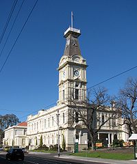 Camberwell City Hall
The City of Boroondara is a Local Government Area in Victoria, Australia. It is located in the eastern suburbs of Melbourne.
This area was originally occupied by the Wurundjeri, Indigenous Australians of the Kulin nation.
In 1837, John Gardiner (after whom Gardiners Creek was named) and his family were the first Europeans to settle here.
Robert Hoddle surveyed the area in 1837 and declared it the "Parish of Boroondara". The area was densely wooded, so he took a word from the Woiwurrung language (as spoken by the Wurundjeri), meaning "where the ground is thickly shaded".[2]
The first Local Government body was the Boroondara District Road Board, formed on 11 July 1854 and incorporating the areas which were to become the City of Hawthorn, City of Kew and City of Camberwell. Hawthorn and Kew were created as separate municipalities in 1860 and the remaining area of the Road Board became Shire of Boroondara on 17 November 1871, which later became the City of Camberwell.[3] The three were amalgamated on 15 December 1994 to create the City of Boroondara.
It has an area of 60 km², and in 2009, it had an estimated population of 168,090. Boroondara was rated ninth of 590 Australian Local Government Areas in the BankWest Quality of Life Index 2008.[4]
Contents
Local Government
Boroondara City Council is the third tier of government and deals with services such as garbage collection, building and planning permits and approvals, roads, drainage, health services, youth services, children's services food safety, parks and gardens, library services, pets, street parking permits and the collection of rates and charges.
Boroondara council's main office in Camberwell underwent a $20 million redevelopment. The historical facade facing Camberwell Road remains largely unchanged whereas the main entrance facing Inglesby Road has been refurbished. The project was completed in February, 2010.
Wards and councillors
Ward[5] contains parts of…[5] Past and present councillors[6][7] Bellevue Balwyn North, Kew East Eric Risstrom (1996–2003), Gina Goldsmith (2003–2004), Luke Tobin (2004–2008), Brad Miles (2008–present) Cotham Kew, Balwyn, Balwyn North Geoff Hayes (1996–2004), Lachlan Williams (2004–2007), Phil Meggs (2007–2008), David Bloom (2008–present) Gardiner Glen Iris, Hawthorn East, Hawthorn, Camberwell Will Charlton (1996–2002), Coral Ross (2002–present) Glenferrie Hawthorn, Kew Nigel Kirby (1996–1999), Meredith Butler (1999–2008), Phil Meggs (2008–present) Junction Camberwell, Hawthorn East, Canterbury Lilian Weinberg (1996–1999), Martina Hayes (1999–2002), Jack Wegman (2002–present) Lynden Camberwell, Glen Iris, Canterbury Ian Wallace (1996–2002), Heinz Kreutz (2002–present) Maling Canterbury, Surrey Hills, Balwyn Loreto Davey (1996–2002), Dennis Whelan (2002–2004), Dick Menting (2004–present) Maranoa Balwyn, Balwyn North, Chris Pattas (1996–2004), Nicholas Tragas (2004–present) Solway Ashburton, Glen Iris Keith Walter (1996–2004), Mary Halikias-Byrnes (2004–2008), Kevin Chow (2008–present) Studley Kew, Hawthorn Paula Davey (1996–1999), Judith Voce (1999–2004), Phillip Healey (2004–present) Boroondara mayors
Infrastructure
The Council is responsible for the management of stormwater collection and removal. The water supply authority is Yarra Valley Water.
Libraries
The City of Boroondara has five libraries at Camberwell, Ashburton, Balwyn, Kew and Hawthorn.
Schools
Boroondara contains many private schools, including Xavier College, Methodist Ladies' College (MLC), Camberwell Grammar School, Trinity Grammar School, Ruyton Girls' School, Carey Baptist Grammar School, Scotch College, Fintona Girls' School, Genazzano FCJ College and Preshil. It contains Catholic schools such as St Michael's Parish School (Ashburton) and St Bede's School (Balwyn North) and a number of public schools, including Canterbury Girls Secondary College, Balwyn High School, Kew High School Solway Primary School and Camberwell High School.
Suburbs of the City of Boroondara | Melbourne | Victoria Ashburton · Balwyn · Balwyn North · Camberwell · Canterbury · Deepdene · Glen Iris · Hawthorn · Hawthorn East · Kew · Kew East · Mont Albert · Surrey Hills
Some of the suburbs mentioned above are shared with other City Councils,
- Glen Iris (shared with City of Stonnington)
- Mont Albert (shared with City of Whitehorse)
- Surrey Hills (shared with City of Whitehorse)
Major thoroughfares
- Auburn Road
- Balwyn Road
- Barkers Road

- Belmore Road
- Burke Road

- Burwood Road

- Camberwell Road
- Canterbury Road
- Chandler Highway

- Church Street


- Cotham Road

- Denmark Street
- Doncaster Road
- Eastern Freeway

- Glenferrie Road

- High Street, Ashburton

- High Street, Kew
- Mont Albert Road
- Power Street
- Princess Street
- Riversdale Road

- Studley Park Road
- Toorak Road

- Tooronga Road
- Union Road
- Warrigal Road

- Whitehorse Road
See also
References
- ^ Australian Bureau of Statistics (30 March 2010). "Regional Population Growth, Australia, 2008–09` - Victoria". http://www.abs.gov.au/ausstats/abs@.nsf/Products/3218.0~2008-09~Main+Features~Victoria?OpenDocument. Retrieved 3 May 2010.
- ^ "Local History and Heritage". City of Boroondara. http://boroondara.mylithio.com/about/historyandheritage.
- ^ Victorian Municipal Directory. Brunswick: Arnall & Jackson. 1992. pp. 327–328, 393, 406. Accessed at State Library of Victoria, La Trobe Reading Room.
- ^ "BankWest Quality of Life Index 2008" (pdf). BankWest Quality of Life Index 2008. BankWest. 2008-08-20. pp. 8. http://www.bankwest.com.au/library/scripts/objectifyMedia.aspx?file=pdf/43/12.pdf&str_title=Complete%20Quality%20of%20Life%20Rankings%202008.pdf. Retrieved 2008-09-03.
- ^ a b "Wards and suburbs". City of Boroondara. http://www.boroondara.vic.gov.au/council/crs_wards/communities. Retrieved 2009-03-17.[dead link]
- ^ "City of Boroondara". Australian Electoral Commission. http://www.vec.vic.gov.au/BoroondaraHome.html. Retrieved 2008-03-12.[dead link]
- ^ "Former Boroondara Councillors". City of Boroondara. http://boroondara.mylithio.com/council/crs_wards/formercouncillors. Retrieved 2008-03-12.[dead link]
External links
Local Government Areas of Victoria Greater Melbourne Inner MelbourneMetropolitanBanyule · Bayside · Boroondara · Darebin · Glen Eira · Hobsons Bay · Kingston · Maribyrnong · Maroondah · Monash · Moonee Valley · Moreland · WhitehorseOuter MetropolitanBrimbank · Cardinia · Casey · Frankston · Greater Dandenong · Hume · Knox · Manningham · Melton · Mornington Peninsula · Nillumbik · Whittlesea · Wyndham · Yarra RangesSouthwest Central Highlands and Goldfields Goulburn Valley Northeast Gippsland Western District Wimmera The Mallee Categories:- Populated places established in 1994
- 1994 establishments in Australia
- Local Government Areas in Melbourne
- Local Government Areas of Victoria (Australia)

Wikimedia Foundation. 2010.