- City of Camberwell
-
City of Camberwell
Victoria
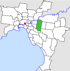
Location in MelbournePopulation: 91,000 (1992)[1] Established: 1914 Area: 36.01 km² (13.9 sq mi) Council Seat: Camberwell Region: Melbourne County: Bourke LGAs around City of Camberwell: Heidelberg Doncaster & Templestowe Doncaster & Templestowe Kew City of Camberwell Box Hill Hawthorn Malvern Waverley 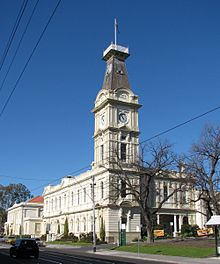 Camberwell Town Hall
The City of Camberwell was a Local Government Area located about 10 kilometres (6 mi) east of Melbourne, the state capital of Victoria, Australia. The city covered an area of 36.01 square kilometres (13.90 sq mi), and existed from 1914 until 1994.
Contents
History
Camberwell was first incorporated as the Boroondara Roads District on 11 July 1864, which became the Shire of Boroondara on 17 November 1871. At this point, Camberwell consisted of two small settlements—one near the Camberwell Inn and the other to the east at Hartwell. Much of the shire's area was under cultivation with a few sites for fine residences at the northern end.[2]
The Shire was renamed to Shire of Camberwell and Boroondara on 16 May 1905. It became a borough on 28 April 1905, the Town of Camberwell on 15 May 1906 and a City by proclamation on 20 April 1914.[3]
The council's pathway to amalgamation was a little different to most—following a redevelopment deal for land behind the Burke Road shops which was rejected by most residents, the Council reneged on the deal and had damages awarded against it. On 22 June 1993 the Council was suspended and replaced with a commissioner. At the same time, a major reform of local government in Victoria was taking place, and the decision was made to merge Camberwell with the Cities of Hawthorn and Kew into the newly-created City of Boroondara, which took effect on 22 June 1994.[2][4]
Council meetings were held at Camberwell Town Hall in Camberwell Road, Camberwell. It presently serves as the council seat for the City of Boroondara.
Wards
The City of Camberwell was subdivided into four wards on 22 May 1934, each electing three councillors:[3]
- North East Ward
- North West Ward
- Centre Ward
- South Ward
Suburbs
- Ashburton
- Balwyn
- Balwyn North
- Burwood (split with City of Box Hill and City of Waverley)
- Camberwell
- Canterbury
- Glen Iris (split with City of Malvern and City of Hawthorn)
- Surrey Hills (split with City of Box Hill)
Population
Year Population 1911 12,551 1933 50,052 1947 76,125 1954 90,397 1958 99,300* 1961 99,353 1966 99,867 1971 98,302 1976 89,865 1981 85,883 1986 83,792 1991 83,799 * Estimate in the 1958 Victorian Year Book.
Further Reading
- Blainey, Geoffrey (1980). A History of Camberwell (Revised ed.). Melbourne: Lothian. ISBN 0850911249.
- Camberwell Conservation Study (1991)[5][6][7][8][9][10][11][12][13][14][15]
References
- ^ Australian Bureau of Statistics, Victoria Office (1994). Victorian Year Book. p. 49. ISSN 0067-1223.
- ^ a b Monash University (1999). "Australian Places - Camberwell". Archived from the original on 2003-10-03. http://web.archive.org/web/20031003042818/http://www.arts.monash.edu.au/ncas/multimedia/gazetteer/list/camberwell.html. Retrieved 2008-01-04.
- ^ a b Victorian Municipal Directory. Brunswick: Arnall & Jackson. 1992. pp. 327–328. Accessed at State Library of Victoria, La Trobe Reading Room.
- ^ Australian Bureau of Statistics (1 August 1995). Victorian local government amalgamations 1994-1995: Changes to the Australian Standard Geographical Classification. Commonwealth of Australia. p. 4. ISBN 0-642-23117-6. http://www.ausstats.abs.gov.au/ausstats/free.nsf/0/76E601D6DB55E88ACA25722500049195/$File/12570_1994-95.pdf. Retrieved 2007-12-16.
- ^ Camberwell Conservation Study 1991 Vol 1 Recommendations & Guidelines - Part 1, City of Camberwell, 1991, archived from the original on 2011-03-13, http://www.webcitation.org/5x9WahOCw
- ^ Camberwell Conservation Study 1991 Vol 1 Recommendations & Guidelines - Part 2, City of Camberwell, 1991, archived from the original on 2011-03-13, http://www.webcitation.org/5x9WtiSZ3
- ^ Camberwell Conservation Study 1991 Vol 1 Recommendations & Guidelines - Part 3, City of Camberwell, 1991, archived from the original on 2011-03-13, http://www.webcitation.org/5x9X1Qphu
- ^ Camberwell Conservation Study 1991 Vol 2, City of Camberwell, 1991, archived from the original on 2011-03-13, http://www.webcitation.org/5x9X6xym9
- ^ Camberwell Conservation Study 1991 Vol 3 - Part 1, City of Camberwell, 1991, archived from the original on 2011-03-13, http://www.webcitation.org/5x9XBT5qU
- ^ Camberwell Conservation Study 1991 Vol 3 - Part 2, City of Camberwell, 1991, archived from the original on 2011-03-13, http://www.webcitation.org/5x9XFA9PS
- ^ Camberwell Conservation Study 1991 Vol 3 - Part 3, City of Camberwell, 1991, archived from the original on 2011-03-13, http://www.webcitation.org/5x9XIb0uQ
- ^ Camberwell Conservation Study 1991 Vol 4 - Part 1, City of Camberwell, 1991, archived from the original on 2011-03-13, http://www.webcitation.org/5x9ZSuSHh
- ^ Camberwell Conservation Study 1991 Vol 4 - Part 2, City of Camberwell, 1991, archived from the original on 2011-03-13, http://www.webcitation.org/5x9ZWaHgk
- ^ Camberwell Conservation Study 1991 Vol 4 - Part 3, City of Camberwell, 1991, archived from the original on 2011-03-13, http://www.webcitation.org/5x9ZZt3Pr
- ^ Camberwell Conservation Study 1991 Vol 5, City of Camberwell, 1991, archived from the original on 2011-03-13, http://www.webcitation.org/5x9XWk2aj
Former Local Government Areas in Melbourne, Victoria Altona · Berwick · Box Hill · Brighton · Broadmeadows · Brunswick · Bulla (S) · Camberwell · Caulfield · Chelsea · Coburg · Collingwood · Cranbourne · Croydon · Diamond Valley (S) · Doncaster & Templestowe · Dandenong · Eltham (S) · Essendon · Fitzroy · Flinders (S) · Footscray · Frankston · Hastings (S) · Hawthorn · Healesville (S) · Heidelberg · Keilor · Kew · Lillydale (S) · Malvern · Moorabbin · Mordialloc · Mornington (S) · Northcote · Nunawading · Oakleigh · Pakenham (S) · Port Melbourne · Prahran · Preston · Richmond · Ringwood · Sandringham · Sherbrooke (S) · South Melbourne · Springvale · St Kilda · Sunshine · Upper Yarra (S) · Waverley · Werribee · Williamstown
Categories:- Former Local Government Areas of Victoria (Australia)

Wikimedia Foundation. 2010.