- City of Springvale
-
City of Springvale
Victoria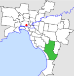
Location in MelbournePopulation: 93,900 (1992)[1] Established: 1857 Area: 97.60 km² (37.7 sq mi) Council Seat: Springvale Region: Melbourne County: Bourke, Mornington LGAs around City of Springvale: Oakleigh Waverley Waverley Moorabbin
MordiallocCity of Springvale Dandenong Chelsea Frankston Cranbourne  Final logo used by the City of Springvale
The City of Springvale was a Local Government Area located about 30 kilometres (19 mi) southeast of Melbourne, the state capital of Victoria, Australia. The city covered an area of 97.60 square kilometres (37.68 sq mi), and existed from 1857 until 1994.
Contents
History
Springvale was first incorporated as the Dandenong Roads District on 6 February 1857. It became a Shire on 16 May 1873. In May 1920, its coastal section split away to form the Borough of Carrum. The Shire of Dandenong was renamed Shire of Springvale and Noble Park on 31 May 1955. In May 1959, it lost 6.5 square kilometres (2.5 sq mi) of land to the City of Oakleigh. The City of Springvale was proclaimed on 22 April 1961.[2]
On 15 December 1994, along with nearly all other councils in Victoria, the City of Springvale was abolished, and split three ways—Carrum Downs was added to the City of Frankston, while the rest split roughly east-west between the new Cities of Greater Dandenong and Kingston.[3]
Council meetings were held at the City Hall at Springvale Road and Grace Park Avenue, Springvale. It presently serves as city offices for the City of Greater Dandenong.
Wards
The City of Springvale was subdivided into four wards in April 1987, each electing three councillors:[2]
- North Ward
- Central Ward
- South Ward
- West Ward
Suburbs
- Aspendale Gardens
- Bangholme (now part of City of Greater Dandenong)
- Braeside (now part of City of Frankston)
- Carrum Downs
- Chelsea Heights
- Dingley Village
- Keysborough (now part of City of Greater Dandenong)
- Noble Park (now part of City of Greater Dandenong)
- Noble Park North (now part of City of Greater Dandenong)
- Patterson Lakes
- Springvale (now part of City of Greater Dandenong)
- Springvale South (now part of City of Greater Dandenong)
Population
Year Population 1958 22,800* 1961 28,542 1966 39,412 1971 58,374 1976 72,474 1981 77,817 1986 83,385 1991 89,478 * Estimate in the 1958 Victorian Year Book.
References
- ^ Australian Bureau of Statistics, Victoria Office (1994). Victorian Year Book. p. 49. ISSN 0067-1223.
- ^ a b Victorian Municipal Directory. Brunswick: Arnall & Jackson. 1992. pp. 489–490. Accessed at State Library of Victoria, La Trobe Reading Room.
- ^ Australian Bureau of Statistics (1 August 1995). Victorian local government amalgamations 1994-1995: Changes to the Australian Standard Geographical Classification. Commonwealth of Australia. p. 6, 8. ISBN 0-642-23117-6. http://www.ausstats.abs.gov.au/ausstats/free.nsf/0/76E601D6DB55E88ACA25722500049195/$File/12570_1994-95.pdf. Retrieved 2007-12-16.
Former Local Government Areas in Melbourne, Victoria Altona · Berwick · Box Hill · Brighton · Broadmeadows · Brunswick · Bulla (S) · Camberwell · Caulfield · Chelsea · Coburg · Collingwood · Cranbourne · Croydon · Diamond Valley (S) · Doncaster & Templestowe · Dandenong · Eltham (S) · Essendon · Fitzroy · Flinders (S) · Footscray · Frankston · Hastings (S) · Hawthorn · Healesville (S) · Heidelberg · Keilor · Kew · Lillydale (S) · Malvern · Moorabbin · Mordialloc · Mornington (S) · Northcote · Nunawading · Oakleigh · Pakenham (S) · Port Melbourne · Prahran · Preston · Richmond · Ringwood · Sandringham · Sherbrooke (S) · South Melbourne · Springvale · St Kilda · Sunshine · Upper Yarra (S) · Waverley · Werribee · Williamstown
Categories:- Former Local Government Areas of Victoria (Australia)

Wikimedia Foundation. 2010.