- City of Cranbourne
-
City of Cranbourne
Victoria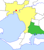
Location in MelbournePopulation: 82,700 (1993)[1] Established: 1860 Area: 755 km² (291.5 sq mi) Council Seat: Cranbourne Region: Outer Southeast Melbourne County: Mornington LGAs around City of Cranbourne: Dandenong Berwick Pakenham Springvale
FrankstonCity of Cranbourne Pakenham Hastings Western Port Korumburra  Final logo used by the City of Cranbourne
The City of Cranbourne was a Local Government Area located about 45 kilometres (28 mi) southeast of Melbourne, the state capital of Victoria, Australia. The City covered an area of 755 square kilometres (291.5 sq mi), and existed from 1860 until 1994. It was notable for being the last local government area to be declared a City prior to the large-scale amalgamations of 1994—its former designation was the Shire of Cranbourne.
Contents
History
The Cranbourne Roads District was first incorporated on 19 June 1860 and became a Shire on 6 March 1868. On 27 January 1893, it annexed part of the Shire of Buln Buln around the areas of Koo Wee Rup and Lang Lang, while on 6 May 1919 it lost some of its territory to the Shire of Frankston and Hastings.[2] From the 1950s onwards, industrial development started to spread southwards from Dandenong and by the 1980s Cranbourne was part of Melbourne's southeastern growth corridor and had essentially become a dormitory suburb of Dandenong and Melbourne. However, eastern parts of the Shire were still rural in character, with dairying, market gardening, potato growing and animal breeding being primary pursuits.[3]
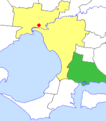
On 22 April 1994, Cranbourne was proclaimed a city by the Governor of Victoria, Richard McGarvie. However, less than eight months later on 15 December 1994, the City was abolished and split into six portions of varying sizes. The largest sections were given to the City of Casey which received Cranbourne, Hampton Park, and the rural/semi-rural areas of Devon Meadows, Clyde and coastal villages including Tooradin. The City of Frankston received Langwarrin, Carrum Downs and Skye, and other smaller transfers included:[4]
- Dandenong South and parts of Lyndhurst to the City of Greater Dandenong;
- Koo Wee Rup and Lang Lang to the Shire of Cardinia and Bass Coast Shire;
- A small part of Pearcedale to the Shire of Mornington Peninsula.
An article in The Age in July 1994 reported that Cranbourne was "losing the fight to remain separate". During the submission process, the council had wanted to remain as is with no merger or loss of territory, as it was fast-growing and needed its entire rate base.[5] In its final year of existence, Cranbourne was one of the five fastest growing municipalities in Australia, in marked contrast to most of the rest of the state.[1]
Council met at Shire Offices in Sladen Street, Cranbourne, which were a purpose-built facility opened in 1978. The building was sold by Casey City Council in 1995 and is now used as a health care facility, known as the 'Cranbourne Integrated Care Centre'. Prior to 1978, the Shire of Cranbourne met at the 'Old Shire Offices', which is next to the buildings built in 1978.[6] This building is now used as a venue for council meetings by the City of Casey, as well as hosting many historical artefacts of the former shire.
Wards
The shire was divided into four ridings, each of which elected three councillors. On becoming a city, the ridings became wards.
- North Riding
- East Riding
- Centre Riding
- West Riding
Suburbs and localities
Outer Metropolitan:
- Baxter (split with City of Frankston and Shire of Hastings)
- Carrum Downs (split with City of Springvale)
- Clyde
- Clyde North
- Cranbourne
- Cranbourne East*
- Cranbourne North
- Cranbourne South
- Cranbourne West*
- Dandenong South (split with City of Dandenong)
- Devon Meadows
- Hampton Park
- Junction Village
- Langwarrin
- Lynbrook*
- Lyndhurst
- Skye
Rural:
- Bayles
- Blind Bight
- Caldermeade
- Cannons Creek
- Cardinia
- Catani
- Dalmore
- Heath Hill
- Koo Wee Rup
- Lang Lang
- Monomeith
- Pearcedale
- Tooradin
- Warneet
- Yannathan
Population
Year Population 1954 8,201 1958 9,160* 1961 10,908 1966 13,089 1971 16,266 1976 24,968 1981 34,821 1986 47,619 1991 70,821 1992 78,100 * Estimate in the 1958 Victorian Year Book.[7]
References
- ^ a b Plunkett, Richard (21 September 1994). "Cranbourne shines while state growth stagnates". The Age: p. 4.
- ^ Victorian Municipal Directory. Brunswick: Arnall & Jackson. 1992. pp. 639–640. Accessed at State Library of Victoria, La Trobe Reading Room.
- ^ Monash University (1999). "Australian Places - Cranbourne Shire". Archived from the original on 2003-04-29. http://web.archive.org/web/20030429161021/http://www.arts.monash.edu.au/ncas/multimedia/gazetteer/list/cranbnshire.html. Retrieved 2008-01-04.
- ^ Australian Bureau of Statistics (1 August 1995). Victorian local government amalgamations 1994-1995: Changes to the Australian Standard Geographical Classification. Commonwealth of Australia. p. 4–12. ISBN 0-642-23117-6. http://www.ausstats.abs.gov.au/ausstats/free.nsf/0/76E601D6DB55E88ACA25722500049195/$File/12570_1994-95.pdf. Retrieved 2007-12-16.
- ^ Neales, Sue (27 July 1994). "Crunch time for councils in south and south-east". The Age: p. 8.
- ^ Hooper, F.C. (Frederick) (1988). The good country : into the dawn of a new day : (1968-1988) : Shire of Cranbourne. ISBN 0-731-63931-6. (119 pages)
- ^ Australian Bureau of Statistics, Victoria Office. Victorian Year Book. ISSN 0067-1223.
Former Local Government Areas in Melbourne, Victoria Altona · Berwick · Box Hill · Brighton · Broadmeadows · Brunswick · Bulla (S) · Camberwell · Caulfield · Chelsea · Coburg · Collingwood · Cranbourne · Croydon · Diamond Valley (S) · Doncaster & Templestowe · Dandenong · Eltham (S) · Essendon · Fitzroy · Flinders (S) · Footscray · Frankston · Hastings (S) · Hawthorn · Healesville (S) · Heidelberg · Keilor · Kew · Lillydale (S) · Malvern · Moorabbin · Mordialloc · Mornington (S) · Northcote · Nunawading · Oakleigh · Pakenham (S) · Port Melbourne · Prahran · Preston · Richmond · Ringwood · Sandringham · Sherbrooke (S) · South Melbourne · Springvale · St Kilda · Sunshine · Upper Yarra (S) · Waverley · Werribee · Williamstown
Categories:- Former Local Government Areas of Victoria (Australia)
Wikimedia Foundation. 2010.