- City of Mordialloc
-
City of Mordialloc
Victoria
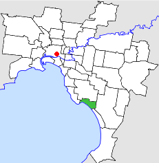
Location in MelbournePopulation: 27,900 (1992)[1] Established: 1920 Area: 13.57 km² (5.2 sq mi) Council Seat: Mentone Region: Melbourne County: Mornington LGAs around City of Mordialloc: Moorabbin Moorabbin Springvale Sandringham City of Mordialloc Springvale Port Phillip Port Phillip Chelsea  Final logo used by the City of Mordialloc
The City of Mordialloc was a Local Government Area located about 20 kilometres (12 mi) south of Melbourne, the state capital of Victoria, Australia, on the eastern side of Port Phillip. The city covered an area of 13.57 square kilometres (5.24 sq mi), and existed from 1920 until 1994.
Contents
History
Mordialloc was originally part of the Shire of Moorabbin, and was severed and incorporated as the Borough of Mentone and Mordialloc on 26 May 1920. It increased in size on 18 May 1921 by absorbing another small section of Moorabbin. It was declared a Town on 17 April 1923 and its name changed to Mordialloc a week later. It was proclaimed a City on 5 May 1926.[2]
On 15 December 1994, along with nearly all other councils in Victoria, the City of Mordialloc was abolished and merged into the newly-created City of Kingston along with Chelsea and parts of Moorabbin. The eastern section of Beaumaris was included in the new City of Bayside.[3]
Council meetings were held at Mentone Town Hall at Mentone Parade, Mentone. It presently serves as a council service centre and library for the City of Kingston.
Wards
The City of Mordialloc was subdivided into three wards, each electing three councillors:[2]
- Mentone Ward
- Parkdale Ward
- Mordialloc Ward
Suburbs
- Beaumaris (split with City of Sandringham and City of Moorabbin)
- Mentone (split with City of Moorabbin)
- Mordialloc
- Parkdale
Population
Year Population 1933 9,216 1954 21,025 1958 24,500* 1961 26,526 1966 28,058 1971 29,753 1976 28,615 1981 27,869 1986 26,817 1991 26,325 * Estimate in the 1958 Victorian Year Book.
References
- ^ Australian Bureau of Statistics, Victoria Office (1994). Victorian Year Book. p. 49. ISSN 0067-1223.
- ^ a b Victorian Municipal Directory. Brunswick: Arnall & Jackson. 1992. pp. 430–431. Accessed at State Library of Victoria, La Trobe Reading Room.
- ^ Australian Bureau of Statistics (1 August 1995). Victorian local government amalgamations 1994-1995: Changes to the Australian Standard Geographical Classification. Commonwealth of Australia. p. 4,8. ISBN 0-642-23117-6. http://www.ausstats.abs.gov.au/ausstats/free.nsf/0/76E601D6DB55E88ACA25722500049195/$File/12570_1994-95.pdf. Retrieved 2007-12-16.
Former Local Government Areas in Melbourne, Victoria Altona · Berwick · Box Hill · Brighton · Broadmeadows · Brunswick · Bulla (S) · Camberwell · Caulfield · Chelsea · Coburg · Collingwood · Cranbourne · Croydon · Diamond Valley (S) · Doncaster & Templestowe · Dandenong · Eltham (S) · Essendon · Fitzroy · Flinders (S) · Footscray · Frankston · Hastings (S) · Hawthorn · Healesville (S) · Heidelberg · Keilor · Kew · Lillydale (S) · Malvern · Moorabbin · Mordialloc · Mornington (S) · Northcote · Nunawading · Oakleigh · Pakenham (S) · Port Melbourne · Prahran · Preston · Richmond · Ringwood · Sandringham · Sherbrooke (S) · South Melbourne · Springvale · St Kilda · Sunshine · Upper Yarra (S) · Waverley · Werribee · Williamstown
Categories:- Former Local Government Areas of Victoria (Australia)
Wikimedia Foundation. 2010.