- Shire of Pakenham
Infobox Australian Place | type = lga
name = Shire of Pakenham
state = vic
region = Outer SoutheastMelbourne
area = 874
est = 1862
seat = Pakenham
pop = 29,500 (1992) [cite book|title=Victorian Year Book|author=Australian Bureau of Statistics, Victoria Office|year=1994|page=49|id=ISSN 0067-1223]
logosize =
imagesize = 150
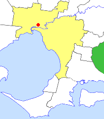
caption = Location inMelbourne
county = Mornington, Evelyn
near-nw = Sherbrooke
near-n = Sherbrooke
near-ne = Upper Yarra
near-w = Berwick
near-e = Buln Buln
near-sw = Cranbourne
near-s = Korumburra
near-se = Korumburra
_noautocat = yesThe Shire of Pakenham was a Local Government Area located about convert|60|km|mi|0 southeast of
Melbourne , the state capital of Victoria,Australia . The shire covered an area of convert|874|km2|sqmi|1, and existed from 1862 until 1994.History
The Berwick Roads District was first incorporated on 24 October 1862 and became a Shire on 12 May 1868. At the time, it was a considerably larger area extending well into what is now Melbourne's eastern and southeastern suburbs - including today's
City of Knox as well as areas east of Dandenong as well as theDandenong Ranges .On 23 May 1889, the Scoresby Riding was severed and incorporated as the Shire of Fern Tree Gully. Fern Tree Gully in turn splintered in 1964 to form the
City of Knox andShire of Sherbrooke .In 1902, the Berwick Shire headquarters moved to Pakenham. The Shire was generally rural in character, with fruit growing, dairying and sheep and cattle grazing being the main pursuits. However, from the 1950s onward, the western part around Berwick and Narre Warren experienced major residential growth as well as industrial development.cite web|url=http://web.archive.org/web/20030802021344/www.arts.monash.edu.au/ncas/multimedia/gazetteer/list/berwshire.html|title=Australian Places - Berwick Shire|author=
Monash University |year=1999|accessdate=2008-01-04] On 1 October 1973, the western part split from the Shire and was immediately proclaimed as theCity of Berwick . The remaining rural area was renamed Shire of Pakenham on 1 September 1974.cite book|title=Victorian Municipal Directory|year=1992|publisher=Arnall & Jackson|location=Brunswick|pages=805-806, 832-833 Accessed atState Library of Victoria , La Trobe Reading Room.]On 15 December 1994, along with nearly all other councils in Victoria, the Shire of Pakenham was abolished, and merged with sections of the
Shire of Sherbrooke (around Emerald and Cockatoo) and theCity of Cranbourne (Koo Wee Rup and Lang Lang) to form the newShire of Cardinia . [cite book|url=http://www.ausstats.abs.gov.au/ausstats/free.nsf/0/76E601D6DB55E88ACA25722500049195/$File/12570_1994-95.pdf|title=Victorian local government amalgamations 1994-1995: Changes to the Australian Standard Geographical Classification|author=Australian Bureau of Statistics |date=1 August 1995|publisher=Commonwealth of Australia|page=5|isbn=0-642-23117-6|accessdate=2007-12-16]Council met at the Shire Offices in Duncan Drive, Pakenham. The facility is now the headquarters for the
Shire of Cardinia .Wards
The shire was divided into four ridings on 1 April 1988, each of which elected three councillors:
* Beacon Hills Ward
* Iona Ward
* Ranges Ward
* Toomuc Warduburbs and Localities
Outer Metropolitan:
* Beaconsfield (split withCity of Berwick )
* Beaconsfield Upper
* Cockatoo
* Emerald (split withShire of Sherbrooke )
* Gembrook
* Officer
* Pakenham
* Pakenham South
* Pakenham UpperRural:
* Bunyip
* Bunyip North
* Cora Lynn
* Dewhurst
* Garfield
* Iona
* Maryknoll
* Nar Nar Goon
* Nar Nar Goon North
* Tonimbuk
* Toomuc Valley
* Tynong
* VervalePopulation
* Estimate in the 1958 Victorian Year Book.
* Includes 20,474 from Berwick district and 12,636 from Pakenham district.References
Wikimedia Foundation. 2010.