- City of Malvern
-
City of Malvern
Victoria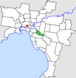
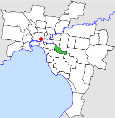
Location in MelbournePopulation: 43,600 (1992)[1] Established: 1856 Area: 15.88 km² (6.1 sq mi) Council Seat: Malvern Region: Melbourne County: Bourke LGAs around City of Malvern: Hawthorn Camberwell Waverley Prahran City of Malvern Oakleigh Caulfield Caulfield Oakleigh The City of Malvern was a Local Government Area located about 9 kilometres (6 mi) southeast of Melbourne, the state capital of Victoria, Australia. The city covered an area of 15.88 square kilometres (6.13 sq mi), and existed from 1856 until 1994.
Contents
History
Malvern was incorporated as the Gardiner District on 17 October 1856, which became the Shire of Gardiner on 26 May 1871. It was renamed Shire of Malvern on 15 February 1878. It then became a borough on 22 February 1901, a town on 24 April 1901 and a City on 30 May 1911.[2]
On 22 June 1994, the City of Malvern was abolished and merged with Prahran into the newly-created City of Stonnington.[3]
Council meetings were held at Malvern Town Hall on Glenferrie Road and High Street, Malvern. It presently serves as a service centre for the City of Stonnington.
Mayors
Main article: List of mayors of MalvernWards
The City of Malvern was subdivided into four wards in October 1980, each electing three councillors:[2]
- Centre Ward
- East Ward
- North Ward
- South Ward
Suburbs
- Armadale (split with City of Prahran)
- Glen Iris (split with City of Camberwell)
- Kooyong
- Malvern
- Malvern East
- Toorak (split with City of Prahran)
Population
Year Population 1954 46,910 1958 45,800* 1961 47,870 1966 49,975 1971 50,560 1976 45,566 1981 43,211 1986 41,777 1991 41,340 * Estimate in the 1958 Victorian Year Book.
References
- ^ Australian Bureau of Statistics, Victoria Office (1994). Victorian Year Book. p. 49. ISSN 0067-1223.
- ^ a b Victorian Municipal Directory. Brunswick: Arnall & Jackson. 1992. pp. 411–412. Accessed at State Library of Victoria, La Trobe Reading Room.
- ^ Australian Bureau of Statistics (1 August 1995). Victorian local government amalgamations 1994-1995: Changes to the Australian Standard Geographical Classification. Commonwealth of Australia. p. 11. ISBN 0-642-23117-6. http://www.ausstats.abs.gov.au/ausstats/free.nsf/0/76E601D6DB55E88ACA25722500049195/$File/12570_1994-95.pdf. Retrieved 2007-12-16.
Former Local Government Areas in Melbourne, Victoria Altona · Berwick · Box Hill · Brighton · Broadmeadows · Brunswick · Bulla (S) · Camberwell · Caulfield · Chelsea · Coburg · Collingwood · Cranbourne · Croydon · Diamond Valley (S) · Doncaster & Templestowe · Dandenong · Eltham (S) · Essendon · Fitzroy · Flinders (S) · Footscray · Frankston · Hastings (S) · Hawthorn · Healesville (S) · Heidelberg · Keilor · Kew · Lillydale (S) · Malvern · Moorabbin · Mordialloc · Mornington (S) · Northcote · Nunawading · Oakleigh · Pakenham (S) · Port Melbourne · Prahran · Preston · Richmond · Ringwood · Sandringham · Sherbrooke (S) · South Melbourne · Springvale · St Kilda · Sunshine · Upper Yarra (S) · Waverley · Werribee · Williamstown
Categories:- Former Local Government Areas of Victoria (Australia)
Wikimedia Foundation. 2010.