- City of South Melbourne
-
This article is about a former local government area. For the suburb, see South Melbourne, Victoria.
City of South Melbourne
Victoria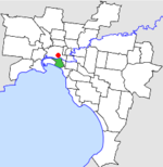
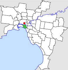
Location in MelbournePopulation: 17,600 (1992)[1] Established: 1855 Area: 8.91 km² (3.4 sq mi) Council Seat: South Melbourne Region: Melbourne County: Bourke LGAs around City of South Melbourne: Melbourne Melbourne Melbourne Port Melbourne City of South Melbourne Prahran Port Phillip Port Phillip St Kilda 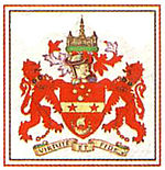 Final logo used by the City of South Melbourne
The City of South Melbourne was a Local Government Area located about 2 kilometres (1.2 mi) south of Melbourne, the state capital of Victoria, Australia, on the south bank of the Yarra River. The city covered an area of 8.91 square kilometres (3.44 sq mi), and existed from 1855 until 1994.
The council area was bounded by the Yarra River to the north, Fraser and Lorne Streets to the south, the Port Phillip foreshore and Pickles Street to the west, and St Kilda Road to the east.[2]
Contents
History
South Melbourne was first incorporated as the Emerald Hill Borough on 26 May 1855, and became a Town on 1 March 1872. It was proclaimed a City and was renamed to South Melbourne on 21 September 1883.[2]
On 18 November 1993, a small portion around Southbank and the Victorian Arts Centre was added to the City of Melbourne.[3] On 22 June 1994, the City of South Melbourne was abolished and merged into the newly-created City of Port Phillip along with the Cities of Port Melbourne and St Kilda.[4]
The council met at the South Melbourne Town Hall on Bank Street between Fishley and Layfield Streets, South Melbourne. The hall still exists and is now used by the Australian National Academy of Music.
Wards
South Melbourne was divided into four wards, each electing three councillors:
- Canterbury Ward
- Fawkner Ward
- Hobson Ward
- Queens Ward
Suburbs
- Albert Park
- Melbourne (between Queens Road and St Kilda Road)
- Middle Park
- Southbank
- South Melbourne
Population
Year Population 1861 8,822 1881 25,374 1891 41,724 1921 46,873 1954 37,955 1958 35,300* 1961 32,528 1966 30,174 1971 26,995 1976 21,334 1981 19,955 1986 18,499 1991 17,712 * Estimate in the 1958 Victorian Year Book.
References
- ^ Australian Bureau of Statistics, Victoria Office (1994). Victorian Year Book. p. 49. ISSN 0067-1223.
- ^ a b Victorian Municipal Directory. Brunswick: Arnall & Jackson. 1992. pp. 483–484. Accessed at State Library of Victoria, La Trobe Reading Room.
- ^ Monash University (1999). "Australian Places - South Melbourne". Archived from the original on 2003-04-02. http://web.archive.org/web/20030402012038/http://www.arts.monash.edu.au/ncas/multimedia/gazetteer/list/southmelb.html. Retrieved 2008-01-04.
- ^ Australian Bureau of Statistics (1 August 1995). Victorian local government amalgamations 1994-1995: Changes to the Australian Standard Geographical Classification. Commonwealth of Australia. p. 11. ISBN 0-642-23117-6. http://www.ausstats.abs.gov.au/ausstats/free.nsf/0/76E601D6DB55E88ACA25722500049195/$File/12570_1994-95.pdf. Retrieved 2007-12-16.
Former Local Government Areas in Melbourne, Victoria Altona · Berwick · Box Hill · Brighton · Broadmeadows · Brunswick · Bulla (S) · Camberwell · Caulfield · Chelsea · Coburg · Collingwood · Cranbourne · Croydon · Diamond Valley (S) · Doncaster & Templestowe · Dandenong · Eltham (S) · Essendon · Fitzroy · Flinders (S) · Footscray · Frankston · Hastings (S) · Hawthorn · Healesville (S) · Heidelberg · Keilor · Kew · Lillydale (S) · Malvern · Moorabbin · Mordialloc · Mornington (S) · Northcote · Nunawading · Oakleigh · Pakenham (S) · Port Melbourne · Prahran · Preston · Richmond · Ringwood · Sandringham · Sherbrooke (S) · South Melbourne · Springvale · St Kilda · Sunshine · Upper Yarra (S) · Waverley · Werribee · Williamstown
Categories:- Former Local Government Areas of Victoria (Australia)

Wikimedia Foundation. 2010.