- City of Brighton
-
For other uses, see City of Brighton (disambiguation).
City of Brighton
Victoria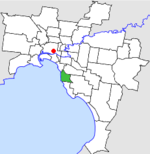
Location in MelbournePopulation: 35,000 (1992)[1] Established: 1859 Area: 13.48 km² (5.2 sq mi) Council Seat: Brighton Region: Melbourne County: Bourke LGAs around City of Brighton: St Kilda Caulfield Caulfield Port Phillip City of Brighton Moorabbin Port Phillip Sandringham Moorabbin  Final logo used by the City of Brighton
The City of Brighton was a Local Government Area located about 10 kilometres (6.2 mi) south of Melbourne, the state capital of Victoria, Australia, on the southeast bank of the Yarra River. The city covered an area of 13.48 square kilometres (5.20 sq mi), and existed from 1859 until 1994.
Contents
History
Brighton was first incorporated as a borough on 18 January 1859. It annexed some land in Elwood and Elsternwick in 1870, and became a town on 18 March 1887. After annexing 13.8 hectares (34.1 acres) from the City of Moorabbin on 3 April 1912, it was proclaimed a City on 12 March 1919.[2] From 1861 onwards, Thomas Bent was associated with the council, being its mayor on several occasions before becoming Treasurer and Premier of Victoria from 1904 until 1909.[3]
Council meetings were held at the court house until 1886 when a stuccoed building, designed by Wilson and Beswicke, was constructed at the corner of Wilson and Carpenter Streets in Brighton and subsequently remodelled in 1933. A new building, housing the council chambers and offices was built in Boxshall Street to mark the centenary of the municipality in 1959.[4] The former town hall is now home to the Bayside Cultural Centre.
On 15 December 1994, along with nearly all other councils in Victoria, the City of Brighton was abolished and merged with the City of Sandringham and parts of the suburbs of Cheltenham, Highett and Beaumaris into the newly-created City of Bayside.[5]
Wards
Brighton was divided into four wards in May 1945, each electing three councillors:
- Centre Ward
- East Ward
- North Ward
- South Ward
Geography
The council area covered the suburbs of Brighton and Brighton East, and was bounded by Port Phillip to the west; Head Street, St Kilda Street and Glen Huntly Road to the north; Nepean Highway, North Road, Thomas Street and Nepean Highway to the east; and South Road and New Street to the south.[6]
Population
Year Population 1861 2,051 1901 10,047 1921 21,235 1947 39,769 1954 40,458 1958 42,000* 1961 41,302 1966 40,594 1971 39,189 1976 35,673 1981 33,697 1986 33,195 1991 32,230 * Estimate in the 1958 Victorian Year Book.
References
- ^ Australian Bureau of Statistics, Victoria Office (1994). Victorian Year Book. p. 49. ISSN 0067-1223.
- ^ Victorian Municipal Directory. Brunswick: Arnall & Jackson. 1992. pp. 318–319. Accessed at State Library of Victoria, La Trobe Reading Room.
- ^ Monash University (1999). "Australian Places - Brighton". Archived from the original on 2003-08-16. http://web.archive.org/web/20030816085238/http://www.arts.monash.edu.au/ncas/multimedia/gazetteer/list/brighton.html. Retrieved 2008-01-04.
- ^ Bate, Weston (1962). A History of Brighton. Melbourne University Press.
- ^ Australian Bureau of Statistics (1 August 1995). Victorian local government amalgamations 1994-1995: Changes to the Australian Standard Geographical Classification. Commonwealth of Australia. p. 4. ISBN 0-642-23117-6. http://www.ausstats.abs.gov.au/ausstats/free.nsf/0/76E601D6DB55E88ACA25722500049195/$File/12570_1994-95.pdf. Retrieved 2007-12-16.
- ^ Melway - Greater Melbourne Street Directory (22nd edition). Glen Iris, Victoria: Melway Publishing Pty Ltd. 1993. pp. Maps 67–68, 76–77. ISSN 0311-3957.
Former Local Government Areas in Melbourne, Victoria Altona · Berwick · Box Hill · Brighton · Broadmeadows · Brunswick · Bulla (S) · Camberwell · Caulfield · Chelsea · Coburg · Collingwood · Cranbourne · Croydon · Diamond Valley (S) · Doncaster & Templestowe · Dandenong · Eltham (S) · Essendon · Fitzroy · Flinders (S) · Footscray · Frankston · Hastings (S) · Hawthorn · Healesville (S) · Heidelberg · Keilor · Kew · Lillydale (S) · Malvern · Moorabbin · Mordialloc · Mornington (S) · Northcote · Nunawading · Oakleigh · Pakenham (S) · Port Melbourne · Prahran · Preston · Richmond · Ringwood · Sandringham · Sherbrooke (S) · South Melbourne · Springvale · St Kilda · Sunshine · Upper Yarra (S) · Waverley · Werribee · Williamstown
Categories:- Former Local Government Areas of Victoria (Australia)

Wikimedia Foundation. 2010.