- City of Moorabbin
-
City of Moorabbin
Victoria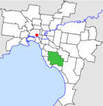
Location in MelbournePopulation: 100,400 (1992)[1] Established: 1862 Area: 53.13 km² (20.5 sq mi) Council Seat: Moorabbin Region: Melbourne County: Bourke LGAs around City of Moorabbin: Brighton Caulfield Oakleigh Sandringham City of Moorabbin Springvale Sandringham Mordialloc Springvale  Final logo used by the City of Moorabbin
The City of Moorabbin was a Local Government Area located about 20 kilometres (12 mi) southeast of Melbourne, the state capital of Victoria, Australia. The city covered an area of 53.13 square kilometres (20.51 sq mi), and existed from 1862 until 1994.
Contents
History
Moorabbin was first incorporated as a district on 16 May 1862. It became a Shire on 27 January 1871, and was essentially rural in character, relying on the villages on its western side for services.[2] As regions on the coast became more urban in character, local severance movements successfully obtained their own local governments. On 3 April 1912, one part united with Brighton to the northwest. On 28 February 1917, Sandringham split away, while on 26 May 1920, the Borough of Mentone and Mordialloc joined them. Eventually, with the development of areas such as Bentleigh and Cheltenham within the Shire's boundaries, it was declared a City on 10 October 1934. On 1 October 1959, it lost a further piece of land to the City of Oakleigh.[3]
On 15 December 1994, along with nearly all other councils in Victoria, the City of Moorabbin was abolished, and split three ways—Bentleigh merged into the new City of Glen Eira along with the City of Caulfield; Cheltenham merged into the new City of Bayside along with Brighton and Sandringham; while the bulk of the City joined with Mordialloc, Chelsea and parts of Springvale to become the City of Kingston.[4]
Municipal offices
The Council originally met in the Plough and Harrow Hotel, a site now occupied by the Moorabbin Junction Hotel on the corner of Nepean Highway and South Road, Moorabbin. The first town hall was built on the other side of South Road in 1867 and enlarged in 1907. In 1931 municipal offices were constructed next to the town hall. A new town hall designed by Bates, Smart and McCutcheon was officially opened in 1963 near the Moorabbin railway station. In 1970, new council chambers and meeting rooms were added.[5][6] The municipal site is currently home to the Kingston City Hall and the Kingston Arts Centre.
Wards
The City of Moorabbin was subdivided into four wards on 21 May 1929, each electing three councillors:[3]
- North Ward
- Centre Ward
- Cheltenham Ward
- Moorabbin Ward
Suburbs
- Beaumaris (split with City of Mordialloc and City of Sandringham)
- Bentleigh
- Bentleigh East
- Cheltenham (split with City of Sandringham)
- Clarinda (split with City of Oakleigh)
- Hampton East
- Heatherton
- Highett
- McKinnon
- Mentone (small section near Moorabbin Airport)
- Moorabbin
- Moorabbin Airport
- Oakleigh South (split with City of Oakleigh)
- Ormond (split with City of Caulfield)
Population
Year Population 1921 7,443 1933 19,006 1947 29,236 1954 65,332 1958 86,800* 1961 95,669 1966 103,716 1971 109,588 1976 103,059 1981 97,810 1986 95,291 1991 94,161 * Estimate in the 1958 Victorian Year Book.
References
- ^ Australian Bureau of Statistics, Victoria Office (1994). Victorian Year Book. p. 49. ISSN 0067-1223.
- ^ Monash University (January 1999). "Australian Places - Moorabbin". Archived from the original on 2003-10-11. http://web.archive.org/web/20031011041107/http://www.arts.monash.edu.au/ncas/multimedia/gazetteer/list/moorabbin.html. Retrieved 2008-03-04.
- ^ a b Victorian Municipal Directory. Brunswick: Arnall & Jackson. 1992. pp. 426–427. Accessed at State Library of Victoria, La Trobe Reading Room.
- ^ Australian Bureau of Statistics (1 August 1995). Victorian local government amalgamations 1994-1995: Changes to the Australian Standard Geographical Classification. Commonwealth of Australia. p. 4, 6, 8. ISBN 0-642-23117-6. http://www.ausstats.abs.gov.au/ausstats/free.nsf/0/76E601D6DB55E88ACA25722500049195/$File/12570_1994-95.pdf. Retrieved 2007-12-16.
- ^ Harvey, Anthony (1982). The Melbourne Book. Australia: Hutchinson Books. ISBN 0091377501.
- ^ "Moorabbin Town Hall". kingston historical website. City of Kingston. http://localhistory.kingston.vic.gov.au/htm/article/378.htm. Retrieved 2008-03-04.
Former Local Government Areas in Melbourne, Victoria Altona · Berwick · Box Hill · Brighton · Broadmeadows · Brunswick · Bulla (S) · Camberwell · Caulfield · Chelsea · Coburg · Collingwood · Cranbourne · Croydon · Diamond Valley (S) · Doncaster & Templestowe · Dandenong · Eltham (S) · Essendon · Fitzroy · Flinders (S) · Footscray · Frankston · Hastings (S) · Hawthorn · Healesville (S) · Heidelberg · Keilor · Kew · Lillydale (S) · Malvern · Moorabbin · Mordialloc · Mornington (S) · Northcote · Nunawading · Oakleigh · Pakenham (S) · Port Melbourne · Prahran · Preston · Richmond · Ringwood · Sandringham · Sherbrooke (S) · South Melbourne · Springvale · St Kilda · Sunshine · Upper Yarra (S) · Waverley · Werribee · Williamstown
Categories:- Former Local Government Areas of Victoria (Australia)

Wikimedia Foundation. 2010.