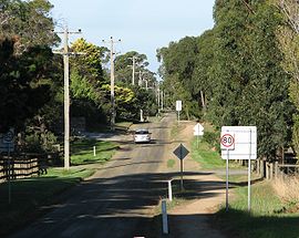
- Devon Meadows, Victoria
-
Devon Meadows
Victoria
Worthing RoadPopulation: 1,594 (2006) [1] Postcode: 3977 Location: - 50 km (31 mi) from Melbourne
- 8 km (5 mi) from Cranbourne
LGA: City of Casey State District: Hastings Federal Division: Flinders Localities around Devon Meadows: Junction Village Cranbourne East Clyde Cranbourne South Devon Meadows Clyde Pearcedale Cannons Creek Tooradin Devon Meadows is a town in Victoria, Australia, 50 km south-east from Melbourne's central business district. Its Local Government Area is the City of Casey. At the 2006 Census, Devon Meadows had a population of 1594.
Devon Meadows Post Office opened on 21 March 1915, and closed in 1941.[2]
Devon Meadows contains a primary school with a current enrolment of about 300,[3] a CFA fire station, community hall and tennis club.
Just east of the main township is a locality known Five Ways after the split intersection where three roads leave the South Gippsland Highway bound for Berwick, Koo Wee Rup and Cannons Creek. A general store at the intersection provides services to travellers.[4]
The town has an Australian Rules football team competing in the Mornington Peninsula Nepean Football League.[5]
Transport
- 795 Cranbourne – Warneet (Monday to Friday). Operated by Cranbourne Transit.
- 796 Cranbourne – Cranbourne (Monday to Friday (school days)). Operated by Cranbourne Transit.
References
- ^ Australian Bureau of Statistics (25 October 2007). "Devon Meadows (State Suburb)". 2006 Census QuickStats. http://www.censusdata.abs.gov.au/ABSNavigation/prenav/LocationSearch?collection=Census&period=2006&areacode=SSC25473&producttype=QuickStats&breadcrumb=PL&action=401. Retrieved 2007-09-15.
- ^ Premier Postal History, Post Office List, https://www.premierpostal.com/cgi-bin/wsProd.sh/Viewpocdwrapper.p?SortBy=VIC&country=, retrieved 2008-04-11
- ^ Schools Online listing, Department of Education (Victoria). Accessed 23 November 2006.
- ^ Map 138, Melway street directory (28th ed., 2001)
- ^ Full Points Footy, Devon Meadows, http://www.fullpointsfooty.net/Devon_Meadows.htm, retrieved 2008-07-25[dead link]
- ^ Cranbourne Transit website, accessed 23 November 2006
External links
- Devon Meadows, Victoria is at coordinates 38°09′43″S 145°18′11″E / 38.162°S 145.303°ECoordinates: 38°09′43″S 145°18′11″E / 38.162°S 145.303°E
Suburbs and Rural Townships of the City of Casey | Victoria Berwick · Blind Bight · Cannons Creek · Clyde · Clyde North · Cranbourne · Cranbourne East · Cranbourne North · Cranbourne South · Cranbourne West · Devon Meadows · Doveton · Endeavour Hills · Eumemmerring · Hallam · Hampton Park · Harkaway · Junction Village · Lynbrook · Lysterfield South · Narre Warren · Narre Warren North · Narre Warren South · Pearcedale · Tooradin · Warneet
Categories:- Towns in Victoria (Australia)
- Melbourne geography stubs
Wikimedia Foundation. 2010.
