- Bass Coast Shire
Infobox Australian Place | type = lga
name = Bass Coast Shire
state = vic
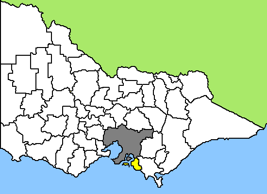
caption = Location in Victoria
pop = 26,548 (2006 Census)
area = 859
est = 1994
seat =
mayor = Neville Goodwin
region =
url = [http://www.basscoast.vic.gov.au www.basscoast.vic.gov.au]
stategov =
fedgov =
near-nw = Casey
near-n = Cardinia
near-ne = Baw Baw
near-w = Mornington Peninsula
near-e = South Gippsland
near-sw = "Bass Strait "
near-s = "Bass Strait "
near-se = "Bass Strait " Bass Coast Shire is a Local Government Area inVictoria, Australia . It is located in the south-eastern part of the state, less than 90 minutes fromMelbourne , and includes the popular tourist destination, Phillip Island. It has an area of 859 square kilometres. In2006 it had apopulation of 26,548.It was formed in
December 1994 from the merger of theShire of Bass ,Shire of Phillip Island ,Borough of Wonthaggi and parts of theShire of Woorayl ,Shire of Korumburra andCity of Cranbourne .Towns and Suburbs
* Almurta
* Anderson
* Archies Creek
* Bass
* Corinella
* Coronet Bay
* Dalyston
* Glen Alvie
* Glen Forbes
* Grantville
* Gurdies, The
* Inverloch
* Jam Jerrup
* Kernot
* Kilcunda
* Kongwak
* Krowera
* Lance Creek
* Pioneer Bay
* Pound Creek
* Ryanston
* San Remo
* Tenby Point
* Wattle Bank
* West Creek
* Woodleigh
* Woolamai* Wonthaggi
** Cape Paterson
** Harmers Haven
** North Wonthaggi
** South Dudley*
Phillip Island
**Cape Woolamai
** Cowes
** Newhaven
** Rhyll
** Silverleaves
** Summerland
** Smiths Beach
** Sunderland Bay
** Sunset Strip
** Ventnor
** Wimbledon HeightsPlaces of Interest / Local Events
*
Australian Motorcycle Grand Prix
*Bass Coast Rail Trail
*Phillip Island Penguin Parade
*Pyramid Rock Festival on New Years Eve
*Seal Rocks Sea Life Centre
* State Coal Mine, Wonthaggi
*Wonthaggi 24 Hour HPV Challenge External links
* [http://www.basscoast.vic.gov.au/ Official website]
* [http://www.phillipislandguide.com/ Phillip Island and Regional Tourist and Holiday Planning Service]
Wikimedia Foundation. 2010.