Kilcunda, Victoria

Kilcunda, Victoria

Infobox Australian Place | type = town
name = Kilcunda
state = vic


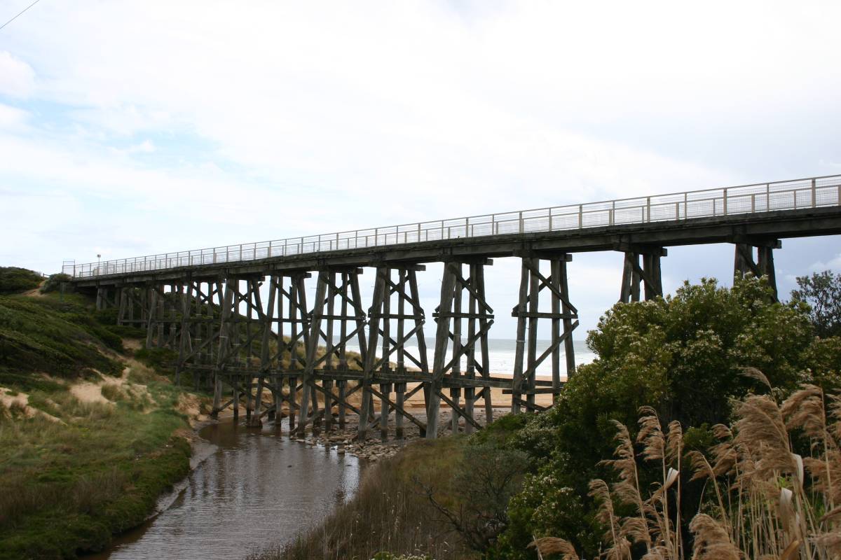
caption = Kilcunda trestle bridge over Bourne Creek on the Rail Trail
lga = Bass Coast Shire
postcode = 3995
est =
pop = 264 (2006)Census 2006 AUS | id = SSC25873 | name = Kilcunda (State Suburb) | accessdate = 2007-10-01 | quick = on]
elevation=
maxtemp =
mintemp =
rainfall =
stategov = Bass
fedgov = Flinders
dist1 = 122
dir1 = SE
location1= Melbourne
dist2 = 15
dir2 = NW
location2= Wonthaggi
dist3 = 28
dir3 = W
location3= Cowes

Kilcunda is a seaside town in Victoria. It is located 117km southeast from Melbourne on the Bass Highway in the Bass Coast Shire of Gippsland, Victoria, Australia. Situated along the rugged coastline between Phillip Island and Wonthaggi, Kilcunda offers excellent fishing, surfing and swimming beaches. At the 2006 census, Kilcunda had a population of 264.

History

Originally a coal mining township, The Western Port Coal Mining Company extracted black coal from 1871. The Post Office opened on 5 August 1879.Citation
last = Premier Postal History | title = Post Office List | url = https://www.premierpostal.com/cgi-bin/wsProd.sh/Viewpocdwrapper.p?SortBy=VIC&country= | accessdate = 2008-04-11
]

Evidence of coal mining is scattered across Kilcunda, the most famous (pictured here) is the old Kilcunda Rail Bridge on the eastern side. Commissioned in 1910 and decommissioned in the 1970s, it now forms part of the Bass Coast Rail Trail stretching convert|16|km|mi|0|lk=on from Wonthaggi to Anderson.

The Town today

Activities around the area now centre on agriculture and tourism and include cycling, fishing, hangliding, surfing, swimming, tennis, and walking. The Bass Coast Rail Trail at Kilcunda is built on the coastal sand dunes and incorporates a landmark trestle bridge over Bourne Creek.

The local football team is Kilcunda-Bass competing in the Alberton Football League. Citation | last = Full Points Footy | title = Kilcunda-Bass | url = http://www.fullpointsfooty.net/Kilcunda_Bass.htm | accessdate = 2008-07-25 ]

ee also

Kilcunda railway station

References


Wikimedia Foundation. 2010.

Игры ⚽ Поможем решить контрольную работу

Look at other dictionaries:

  • Kilcunda-Bass Football Club — Infobox aus sport club | clubname = Kilcunda Bass fullname = Kilcunda Bass Football Club emblem = Panthers strip = White with royal blue hoops founded = 1957 sport = Australian rules football league = Alberton Football League ground = song =… …   Wikipedia

  • Kilcunda railway station, Victoria — VictorianClosedRailwayStation NAME= Kilcunda LINE=Wonthaggi DISTANCE= PLATFORMS= 1 TRACKS= 1 STATUS=Closed OPENED=1910 CLOSED=1978 http://maps.google.com/maps?f=l hl=en q=Nyora+Station near= sll= 38.435001,145.892129 sspn=0.011799,0.020084… …   Wikipedia

  • List of localities in Victoria (Australia) — Map of Local Government Areas in Victoria This is a list of locality names and populated place names in the state of Victoria, Australia, outside the Melbourne metropolitan area. It is organised by region from the south west of the state to the… …   Wikipedia

  • Corinella, Victoria — Corinella Victoria Aerial view of Corinella …   Wikipedia

  • Outtrim, Victoria — Outtrim Victoria …   Wikipedia

  • Cowes, Victoria — Cowes Victoria Golden Cypress trees on Thompson Avenue …   Wikipedia

  • Wonthaggi, Victoria — Infobox Australian Place | type = town name = Wonthaggi state = vic caption = lga = Bass Coast Shire postcode = 3995 est = pop = 4239 (2006)Census 2006 AUS | id = SSC27021 | name = Wonthaggi (State Suburb) | accessdate = 2007 10 01 | quick = on]… …   Wikipedia

  • Bass, Victoria — Infobox Australian Place | type = town name = Bass state = vic caption = lga = Bass Coast Shire postcode = 3991 est = pop = 938 elevation= maxtemp = mintemp = rainfall = stategov = Bass fedgov = Flinders dist1 = 113 dir1 = SE location1= Melbourne …   Wikipedia

  • Wonthaggi railway line, Victoria — The Wonthaggi railway line is a closed railway line located in South Gippsland, Victoria, Australia. Its primary purpose was to serve the State Coal Mine but the line also provided passenger and general goods services. The line was opened in 1910 …   Wikipedia

  • Newhaven, Victoria — Newhaven Victoria Bridge connecting Newhaven with the adjacent town of San Remo …   Wikipedia

Share the article and excerpts

Direct link
Do a right-click on the link above
and select “Copy Link”