- Dingley Village, Victoria
-
Dingley Village
Melbourne, Victoria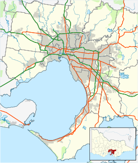
 Dingley Village
Population: 10,072 (2006)[1] Established: 1920s Postcode: 3172 Area: 7.9 km² (3.1 sq mi) Location: 22 km (14 mi) from Melbourne LGA: City of Kingston State District: Mordialloc Federal Division: Hotham Suburbs around Dingley Village: Clarinda Clayton South Springvale Moorabbin Airport Dingley Village Springvale South Mordialloc Braeside Keysborough Dingley Village is a suburb in Melbourne, Victoria, Australia, 22 km south-east from Melbourne's central business district. Its Local Government Area is the City of Kingston. At the 2006 Census, Dingley Village had a population of 10,072.
Contents
History
In 1856 Thomas Attenborough bought land in the area and named his house Dingley Grange, after Dingley Hall which had existed near the town of Melbourne in his native Northamptonshire, England. A farming community developed, relatively remote from either the bayside or Gippsland railway lines, moving into market gardens and poultry to supply metropolitan markets. There was no identifiable centre to the area apart from Christ Church (1873) at the corner of Centre and Old Dandenong Roads, with its attractive architecture and bell tower. The Post Office opened on 21 July 1913.[2]
A family of five brothers - the Gartsides - solved the problem of vegetable gluts by opening a cannery in about 1920. The cannery employed up to fifty local people. They donated land for the primary school which opened in 1925. In 1936 the Kingswood Golf Club, Dandenong, opened its new course at Dingley. A progress association was formed in 1947, and a recreation reserve acquired in 1954.
Urbanisation in Dingley began in the early 1960s. A small shopping centre, school, kindergarten, reserve and, later, Sunday Markets on the reserve created a village atmosphere which resulted in the official change of name.
Two more primary schools, one Catholic, opened later, along with the Spring Park Public Golf course and nearby tennis-courts complex. Near the Moorabbin Airport is an industrial zone set in a garden landscape, separated from the Dingley Village residential area by a reservation for the Mornington Peninsula Freeway.
The rock band Jet originated from the suburb.[3]
Education
- Dingley Primary School [1] (1925), located on the corner of Centre Dandenong and Marcus roads.
- Kingswood Primary School [2] (1976).
- St Mark's Primary School [3] is a Catholic primary school within the Archdiocese of Melbourne.
Community facilities
Primary Schools
Sporting facilities and clubs
- Dingley Baseball & Softball Club
- Dingley (Dingoes) Football Club competing in the Southern Football League.[4]
- Dingley Health Link
- Dingley Netball Club
- Dingley Tennis Club
- Dingley Cricket Club
- Equest Park Equestrian Centre
- Kingswood Golf Club
- Southern Golf Club
- Maroons Netball Club
- Souter and Corrigan Oval
- Spring Park Public Golf Course and Dingley Village Adventure Golf
Churches
- Heatherton-Dingley Uniting Church ("The Little White Church on the Corner")
cnr Old Dandenong Road & Heatherton Roads. Historic building, the church had been a part of the community for 148 years. Traditional style of worship.
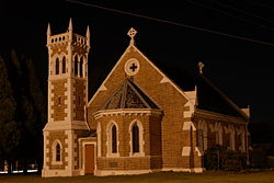 Christ Church Dingley
- Christ Church Dingley
- Destiny Church Melbourne
- The Salvation Army - Kingston Gardens
- Village Church
- St. Mark's Catholic Church
Community associations
- Lions Club - Dingley Village
- Rotary Club of Dingley Village
Landmarks
Statistical data
Statistical data on Dingley Village was collected by the Australian Bureau of Statistics during the 2001 census.
MalesFemalesPersonsTotal Persons
10,623 10,877 21,500 Aged 15 years and over 8,320 8,741 17,061 Aged 65 Years and over 967 1,220 2,187 Aboriginal 7 12 19 Torres Strait Islander 8 5 13 Born in Australia 5,974 6,092 12,066 Born Overseas 4,020 4,164 8,184 Speaks English Only 6,068 6,226 12,294 Speaks another language 4,033 4,146 8,179 Australian Citizen 9,295 9,531 18,826 Australian Citizen aged 18 years or over 6,835 7,168 14,003 See also
- City of Springvale - the former local government area of which Dingley Village was a part.
References
- ^ Australian Bureau of Statistics (25 October 2007). "Dingley Village (State Suburb)". 2006 Census QuickStats. http://www.censusdata.abs.gov.au/ABSNavigation/prenav/LocationSearch?collection=Census&period=2006&areacode=SSC21227&producttype=QuickStats&breadcrumb=PL&action=401. Retrieved 2007-09-29.
- ^ Premier Postal History, Post Office List, https://www.premierpostal.com/cgi-bin/wsProd.sh/Viewpocdwrapper.p?SortBy=VIC&country=, retrieved 2008-04-11
- ^ Holmes, Peter (24 September 2006), "Listen to Jet's new album", Sydney Confidential, http://www.news.com.au/sundaytelegraph/story/0,22049,20458066-5006002,00.html, retrieved 2006-04-29
- ^ Full Point Footy, Southern Football League, http://www.fullpointsfooty.net/southern_football_league.htm, retrieved 2008-10-21
External links
Coordinates: 37°58′52″S 145°07′41″E / 37.981°S 145.128°E
Suburbs of the City of Kingston | Melbourne | Victoria Aspendale · Aspendale Gardens · Braeside · Bonbeach · Carrum · Chelsea · Chelsea Heights · Cheltenham · Clarinda · Clayton South · Dingley Village · Edithvale · Heatherton · Highett · Mentone · Moorabbin · Moorabbin Airport · Mordialloc · Oakleigh South · Parkdale · Patterson Lakes · Waterways
Categories:- Suburbs of Melbourne


Wikimedia Foundation. 2010.