- City of Ballarat
-
City of Ballarat
Victoria
Map of the City of Ballarat's municipal borders, urban areas and location in VictoriaPopulation: 94,088(2009)[1] Area: 740 km² (285.7 sq mi) Mayor: Craig Fletcher Council Seat: Ballarat 
LGAs around City of Ballarat: Pyrenees Hepburn Hepburn Pyrenees City of Ballarat Moorabool Golden Plains Golden Plains Moorabool The City of Ballarat is a Local Government Area in Victoria, Australia around Ballarat. It is located in the western part of the state. It has an area of 740 square kilometres. In 2001 it had a population of 81,000. It was formed in 1994 from the merger of the City of Ballaarat, Shire of Ballarat, Borough of Sebastopol and parts of the Shire of Bungaree, Shire of Buninyong, Shire of Grenville and Shire of Ripon.
Contents
Wards
- Central
- North
- South
Each ward is represented by three elected Councillors.[2]
Administration
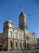
The City of Ballarat council meets at the Ballarat Town Hall on the corner of Sturt and Armstrong Street.
The councils main offices are in modern extension behind the old town hall. Customer services and department offices are at The Phoenix Building at 25 Armstrong Street.
In 2009 the council voted to move to a new headquarters at Civic Hall on Mair Street[3], which would turn the heritage listed Town Hall building into a public general purpose venue.
Sister cities
The City of Ballarat's sister cities are:[4]
- Inagawa, Hyōgo, Japan
- Ainaro, East Timor
References
- ^ Australian Bureau of Statistics (30 March 2010). "Regional Population Growth, Australia, 2008–09". http://www.abs.gov.au/ausstats/abs@.nsf/Latestproducts/3218.0Main%20Features52008-09?opendocument&tabname=Summary&prodno=3218.0&issue=2008-09&num=&view=. Retrieved 3 June 2010.
- ^ Local Government Victoria. "City of Ballarat Council". http://www.localgovernment.vic.gov.au/web20/dvclgv.nsf/AllDocs/2ABA069F77C7003CCA257161001B396A?OpenDocument. Retrieved 2008-10-30
- ^ http://www.thecourier.com.au/news/local/news/general/ballarat-city-council-to-commit-850k-for-civic-hall-site-design/1833679.aspx
- ^ "Sister cities build more than a cultural bond". The Courier. 14 October 2004. http://www.thecourier.com.au/news/local/news/opinion/sister-cities-build-more-than-a-cultural-bond/717324.aspx. Retrieved 25 September 2011.
See also
- List of localities (Victoria)
- Ballarat
External links
 Localities of Greater Ballarat
Addington · Alfredton · Ascot · Bakery Hill · Ballarat Central · Ballarat East · Ballarat North · Black Hill · Bo Peep · Bonshaw · Brown Hill · Buninyong · Bunkers Hill · Burrumbeet · Canadian · Cardigan · Cardigan Village · Chapel Flat · Coghills Creek · Delacombe · Durham Lead · Ercildoune · Eureka · Glen Park · Glendaruel · Glendonnell · Golden Point · Gong Gong · Invermay · Invermay Park · Lake Gardens · Lake Wendouree · Learmonth · Magpie · Miners Rest · Mitchell Park · Mount Clear · Mount Helen · Mount Pleasant · Mount Rowan · Nerrina · Newington · Redan · Scotchmans Lead · Scotsburn · Sebastopol · Soldiers Hill · Tourello · Warrenheip · Weatherboard · Wendouree · Windermere
Local Government Areas of Victoria Greater Melbourne Inner MelbourneMetropolitanBanyule · Bayside · Boroondara · Darebin · Glen Eira · Hobsons Bay · Kingston · Maribyrnong · Maroondah · Monash · Moonee Valley · Moreland · WhitehorseOuter MetropolitanBrimbank · Cardinia · Casey · Frankston · Greater Dandenong · Hume · Knox · Manningham · Melton · Mornington Peninsula · Nillumbik · Whittlesea · Wyndham · Yarra RangesSouthwest Central Highlands and Goldfields Ballarat · Central Goldfields · Greater Bendigo · Hepburn · Loddon · Macedon Ranges · Mitchell · Moorabool · Mount AlexanderGoulburn Valley Northeast Gippsland Western District Wimmera The Mallee Categories:- Local Government Areas of Victoria (Australia)
- Victoria (Australia) geography stubs
Wikimedia Foundation. 2010.

