- Mount Pleasant, Victoria
-
Mount Pleasant
Ballarat, Victoria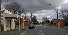
Barkly Street near the intersection of Cobden Street looking south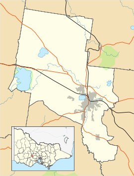
 Mount Pleasant
Population: 1,966[1] Postcode: 3350 Location: 3 km (2 mi) from Ballarat Central LGA: City of Ballarat State District: Ballarat East Federal Division: Ballarat Suburbs around Mount Pleasant: Ballarat Central Golden Point Golden Point Redan Mount Pleasant Canadian Sebastopol Mount Clear Mount Clear Mount Pleasant is a suburb of Ballarat, Victoria, Australia located south of the CBD. It is one of the few original gold mining towns in the Ballarat district established during the Victorian gold rush. At the 2006 census, Mount Pleasant had a population of 1,966.[1]
Mount Pleasant is bordered by the Yarrowee River to the west, Gladstone Street to the north, Magpie and Britain Street to the east and Ballarat Goldfields to the south. The topography varies, from the floodplain of Specimen Vale to Golden Point Hill and southern mining peaks.
Mount Pleasant is organized primarily on a grid plan, with Single-family detached homes on larger than average blocks and a small commercial area on Barkly Street and a small industrial area in the southeast. Some newer subdivisions to the south of the suburb are planned in street hierarchy.
A single bus service, the Buninyong (Route 10) services Mount Pleasant, running along Geelong Road.[2]
References
- ^ a b Australian Bureau of Statistics (25 October 2007). "Mount Pleasant (State Suburb)". 2006 Census QuickStats. http://www.censusdata.abs.gov.au/ABSNavigation/prenav/LocationSearch?collection=Census&period=2006&areacode=SSC23111&producttype=QuickStats&breadcrumb=PL&action=401. Retrieved 2009-06-24.
- ^ Ballarat Bus Network
 Localities of Greater Ballarat
Addington · Alfredton · Ascot · Bakery Hill · Ballarat Central · Ballarat East · Ballarat North · Black Hill · Bo Peep · Bonshaw · Brown Hill · Buninyong · Bunkers Hill · Burrumbeet · Canadian · Cardigan · Cardigan Village · Chapel Flat · Coghills Creek · Delacombe · Durham Lead · Ercildoune · Eureka · Glen Park · Glendaruel · Glendonnell · Golden Point · Gong Gong · Invermay · Invermay Park · Lake Gardens · Lake Wendouree · Learmonth · Magpie · Miners Rest · Mitchell Park · Mount Clear · Mount Helen · Mount Pleasant · Mount Rowan · Nerrina · Newington · Redan · Scotchmans Lead · Scotsburn · Sebastopol · Soldiers Hill · Tourello · Warrenheip · Weatherboard · Wendouree · Windermere
Coordinates: 37°33′03″S 143°51′30″E / 37.55083°S 143.85833°E
Categories:- Suburbs of Ballarat
- Victoria (Australia) geography stubs


Wikimedia Foundation. 2010.