- Ballarat Airport
-
Ballarat Airport 
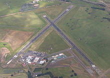
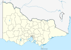
IATA: N/A – ICAO: YBLT Summary Airport type Public Operator City of Ballarat Location Mitchell Park, Ballarat, Victoria Elevation AMSL 1,433 ft / 437 m Coordinates 37°30′42″S 143°47′28″E / 37.51167°S 143.79111°E Runways Direction Length Surface m ft 05/23 1,265 4,150 Asphalt 13/31 568 1,864 Grass 18/36 1,245 4,085 Asphalt Ballarat Airport (ICAO: YBLT) (known officially as the Ballarat Aerodrome) is located at Mitchell Park an outer suburb of Ballarat, Victoria, Australia.
Contents
History
Pilot Training was first offered on the Ballarat Common in 1914-15. In 1934 the airport was formalised with a tin hangar being constructed.
No. 1 Wireless Air Gunners School (1 WAGS)
In 1940 the site was resumed by the Commonwealth of Australia and a Royal Australian Air Force (RAAF) airfield known as Empire Air Training Scheme No 1 Wireless Air Gunners School was established (EATS 1 WAGS) at the Ballarat Showgrounds on 22 April 1940.
The hangar already on the site was relocated to the Commonwealth Flax Mill, and four Bellman Hangars and numerous "P"-type hut buildings were erected. In mid-1940 the Wireless Air Gunners School relocated to the aerodrome. During its operation as a WAGS the wireless operators were mainly trained in panel vans and, from mid 1941, in CAC Wackett trainer aircraft.
No 1 WAGS was disbanded on 31 December 1945.
Post War
Unlike many other EATS sites the RAAF retained the airfield as its Radio School until 1961. The then-Shire of Ballarat negotiated with the Department of Interior to become the civil operator of the airfield and sought the maintenance on site of the hangars and other structures, however a majority of the P Huts were sold by the Commonwealth.[1]
In 2006 the aerodrome was recommended for listing on the Victorian Heritage Register due to its ability to illustrate the Empire Air Training Scheme in Victoria. The site was included on the register on 27 July 2007.[2]
The aerodrome continues to perform an important role in emergency services operation, civial operation, flight training and as accommodation for many community groups and organisations.
Ballarat Location Ballarat, Victoria, Australia Time zone UTC +10 Operator Light Car Club of Australia
Victorian Sporting Car ClubOpened 26 January 1947 Closed 12 February 1961 Major events Victoria Cup, Victoria Trophy Length 5.1 km (3.2 mi) Turns 6 Lap record 1:51 (Dan Gurney, BRM P48, 1961, Formula Libre) Motorsport
The airfield had a brief motor racing career, beginning on Australia Day in 1947 when it held its first motor race meeting. Racing returned in November of both 1950 and 1951, then finally for an International Formula Libre race in February 1961, which was attended by some European Formula 1 teams. BRM factory drivers Dan Gurney and Graham Hill finished first and second in the major race, the Victoria Trophy with Ron Flockhart third in a Cooper. Famously on the night before the race Gurney's car was stolen from its hangar and driven into or hidden with, hay bales out on the track with minimal damage.[3][4]
See also
- United States Army Air Forces in Australia (World War II)
References
 This article incorporates public domain material from websites or documents of the Air Force Historical Research Agency.
- ^ Ballarat Airport - City of Ballarat
- ^ "Former Ballarat RAAF station, Victorian Heritage Register (VHR) Number H2113". Victorian Heritage Database. Heritage Victoria. http://vhd.heritage.vic.gov.au/vhd/heritagevic#detail_places;14247. Retrieved 27 March 2011.
- ^ "This Week in Racing History (February 11–17)". motorsport.com. 11 February 2007. http://www.motorsport.com/news/article.asp?ID=243187&FS=History. Retrieved 26 July 2008.
- ^ Walker, Terry (1995). Fast Tracks. Turton & Armstrong Pty Ltd Publishers. pp. 22 & 23. ISBN 0 908031 55 6.
- Shire of Ballarat History
External links
- Airport information for YBLT at World Aero Data. Data current as of October 2006.
- Ballarat Aero Club
- Ballarat Aviation Museum
- Anson Museum
- Heritage Victoria
Categories:- Airports in Victoria (Australia)
- Motorsport venues in Australia
- Airfields of the United States Army Air Forces in Australia
- Sports venues in Victoria (Australia)
- Victorian Heritage Register
Wikimedia Foundation. 2010.

