Iraak, Victoria

Iraak, Victoria

Infobox Australian Place | type = town
name = Iraak
state = vic


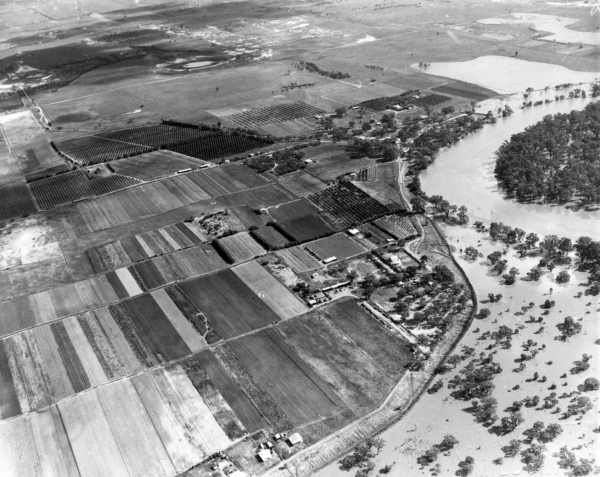
caption = Aerial view of Nangiloc, Iraak and Colignan during the 1956 Murray River flood
lga = Rural City of Mildura
postcode = 3494
pop = 28 (within 7 km radius)
est =
elevation=
maxtemp =
mintemp =
rainfall =
stategov = Mildura
fedgov = Mallee
dist1 = 524
location1= Melbourne
dist2 = 35
location2= Mildura
dist3 = 12
location3= Nangiloc
dist4 = 82
location4= Ouyen [ [http://www.travelmate.com.au/MapMaker/MapMaker.asp Travelmate] ]

Iraak is a town in Victoria, Australia, located approximately 35km south-east from Mildura, Victoria.

Iraak and nearby localities Nangiloc and Colignan were established as soldier settlement farming areas after World War 1, road access to the area being from the west via Boonoonar on what is now the Calder Highway.Citation
last = Nangiloc Public School | title = Colignan Reminiscences | url = http://www.nangilocps.vic.edu.au/.html | accessdate = 2008-08-11
] The Post Office opened on September 22, 1922 the same day as that of Nangiloc, closing in 1960.Citation

last = Premier Postal History | title = Post Office List | url = https://www.premierpostal.com/cgi-bin/wsProd.sh/Viewpocdwrapper.p?SortBy=VIC&country= | accessdate = 2008-04-11 ]

As at October 2007, there is no public transport in Iraak.

ee also

*1956 Murray River flood

References


Wikimedia Foundation. 2010.

Игры ⚽ Нужен реферат?

Look at other dictionaries:

  • Nangiloc, Victoria — Nangiloc Victoria …   Wikipedia

  • Colignan, Victoria — Colignan Victoria The Murray River flows through Colignan. This island is commonly known as Watts s or Colignan Island and is fully submerged when the river is high …   Wikipedia

  • Nichols Point, Victoria — Nichols Point Victoria …   Wikipedia

  • Cowangie, Victoria — Cowangie Victoria The post office at Cowangie, now closed …   Wikipedia

  • Neds Corner, Victoria — Neds Corner Victoria …   Wikipedia

  • Nowingi, Victoria — Nowingi is a locality in Victoria, Australia. Approximately 50 kilometres (31 mi) south of Mildura, the locality is in the Rural City of Mildura local government area. History In May 2004, unreserved Crown land, roughly five kilometres south …   Wikipedia

  • List of localities in Victoria (Australia) — Map of Local Government Areas in Victoria This is a list of locality names and populated place names in the state of Victoria, Australia, outside the Melbourne metropolitan area. It is organised by region from the south west of the state to the… …   Wikipedia

  • Manangatang, Victoria — Manangatang Victoria …   Wikipedia

  • Chillingollah, Victoria — Chillingollah Victoria …   Wikipedia

  • Merbein, Victoria — Merbein Victoria Commercial Street, the main street of Merbein …   Wikipedia

Share the article and excerpts

Direct link
Do a right-click on the link above
and select “Copy Link”