- Colignan, Victoria
-
Colignan
Victoria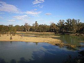
The Murray River flows through Colignan. This island is commonly known as Watts's or Colignan Island and is fully submerged when the river is high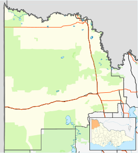
 Colignan
Population: 204[1] Postcode: 3494 Location: LGA: Rural City of Mildura State District: Mildura Federal Division: Mallee Colignan is a small rural town located on the banks of the Murray River, in North Western Victoria, Australia. The town is on the border of the Hattah-Kulkyne National Park. At the 2006 census, Colignan and the surrounding area had a population of 204.[1]
The closest town to Colignan is called Nangiloc which is Colignan spelt in reverse.
Contents
History
Colignan and nearby localities Nangiloc and Iraak were established as soldier settlement farming areas after World War I, road access to the area being from the west via Boonoonar on what is now the Calder Highway.[2] A Post Office opened on August 22, 1922 marking the beginning of postal services to the area. It closed in 1988.[3]
In common with many other soldier settlement areas the blocks provided were too small to be viable and most original settlers had left by the mid 1930s and were replaced by a later generation using irrigation.
The Town today
The economy of the town is based on primary industry, mostly citrus and grape growing. Avocados and almonds are also well represented. The rich soil and the proximity to the Murray River have allowed farming of a diverse range of crops. Dry land farming in the area consists of mainly wheat and barley.[4]
See also
References
- ^ a b Australian Bureau of Statistics (25 October 2007). "Colignan (State Suburb)". 2006 Census QuickStats. http://www.censusdata.abs.gov.au/ABSNavigation/prenav/LocationSearch?collection=Census&period=2006&areacode=SSC25381&producttype=QuickStats&breadcrumb=PL&action=401. Retrieved 2007-07-26.
- ^ Nangiloc Public School, Colignan Reminiscences, archived from the original on 2008-07-18, http://web.archive.org/web/20080718194000/http://www.nangilocps.vic.edu.au/Colignan.html, retrieved 2008-08-11
- ^ Premier Postal History, Post Office List, https://www.premierpostal.com/cgi-bin/wsProd.sh/Viewpocdwrapper.p?SortBy=VIC&country=, retrieved 2008-04-11
- ^ "Soils of the Nangiloc-Colignan irrigation area". Victoria department of agriculture and rural affairs. 1986. http://www.dpi.vic.gov.au/dpi/vro/malregn.nsf/0d08cd6930912d1e4a2567d2002579cb/c278ce6c79147648ca256e1300141b3a/$FILE/Soils%20of%20the%20Nangiloc-Colignan%20area.pdf.
Towns in the Rural City of Mildura Big Desert • Birdwoodton • Boinka • Cabarita • Cardross • Carina • Carwarp • Colignan • Cowangie • Cullulleraine • Hattah • Iraak • Irymple • Koorlong • Kulwin • Lindsay Point • Linga • Merbein • Merbein South • Merbein West • Meringur • Merrinee • Mildura • Mittyack • Murrayville • Nangiloc • Neds Corner • Nichols Point • Ouyen • Panitya • Patchewollock • Red Cliffs • Tempy • Torrita • Tutye • Underbool • Walpeup • Wargan • Werrimull • Yelta •
Coordinates: 34°33′S 142°23′E / 34.55°S 142.383°E

This article about a location in the Mallee is a stub. You can help Wikipedia by expanding it.

