- Saugus, Massachusetts
-
Saugus, Massachusetts — Town — Saugus Town Hall
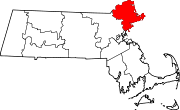
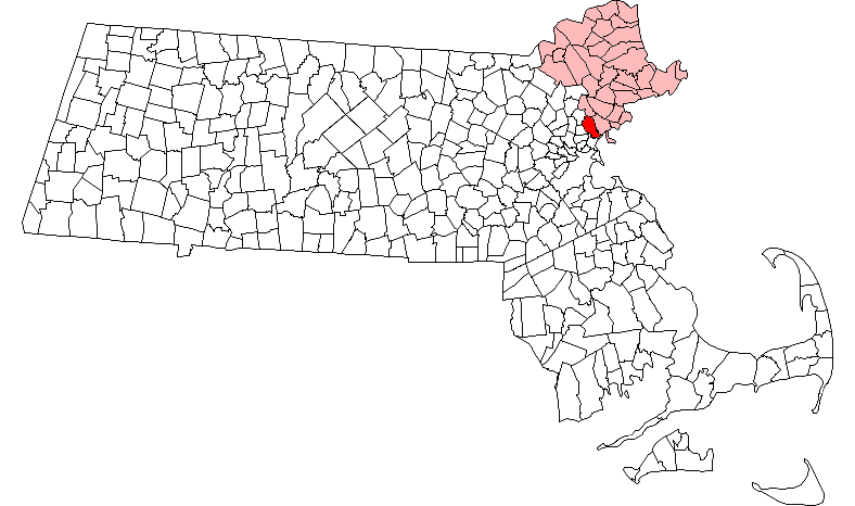
SealLocation in Essex County in Massachusetts
Coordinates: 42°27′53″N 71°00′38″W / 42.46472°N 71.01056°WCoordinates: 42°27′53″N 71°00′38″W / 42.46472°N 71.01056°W Country United States State Massachusetts County Essex Settled 1629 Incorporated 1815 Government - Type Representative town meeting - Town Manager Andrew Bisignani - Board of Selectmen Scott Crabtree
Michael Serino
Stephen Castinetti
Debra Panetta
Stephen HorlickArea - Total 11.8 sq mi (30.4 km2) - Land 11.0 sq mi (28.5 km2) - Water 0.8 sq mi (2.0 km2) Elevation 21 ft (6 m) Population (2010) - Total 26,628 - Density 2,420.7/sq mi (934.3/km2) Time zone Eastern (UTC-5) - Summer (DST) Eastern (UTC-4) ZIP code 01906 Area code(s) 339 / 781 FIPS code 25-60015 GNIS feature ID 0619454 Website http://www.saugus-ma.gov/ Saugus is a town in Essex County, Massachusetts, United States, in the Greater Boston area. The population was 26,628 at the 2010 census.
Contents
History
Saugus was first settled in 1629. Saugus is an Indian name believed to mean "great" or "extended". In 1637, the territory known as Saugus (which also contained the present day cities and towns of Swampscott, Nahant, Lynn, Lynnfield, Reading, and Wakefield) was renamed Lin or Lynn, after King's Lynn in Norfolk, England.[1]
The Saugus Iron Works National Historic Site, in operation from 1646–1668, was the first integrated iron works in North America. It is now a U.S. National Historic Site.[2]
The nineteenth century ice industry began in Saugus when in 1804 Frederic Tudor cut ice from a pond on the family farm and shipped it to Martinique.[3]
The Lynn territory was shortened beginning in 1814 with the incorporation of Lynnfield. On February 17, 1815, present day Saugus was officially incorporated as a town. The first town meeting was held on March 13, 1815 in the parish church. At the time of its incorporation, Saugus' population was 784. Its main industry was agriculture. During the Industrial Revolution, many new industries moved to Saugus. Shoes and woolen goods were made in Saugus Center and tobacco was manufactured in Cliftondale and East Saugus.[4]
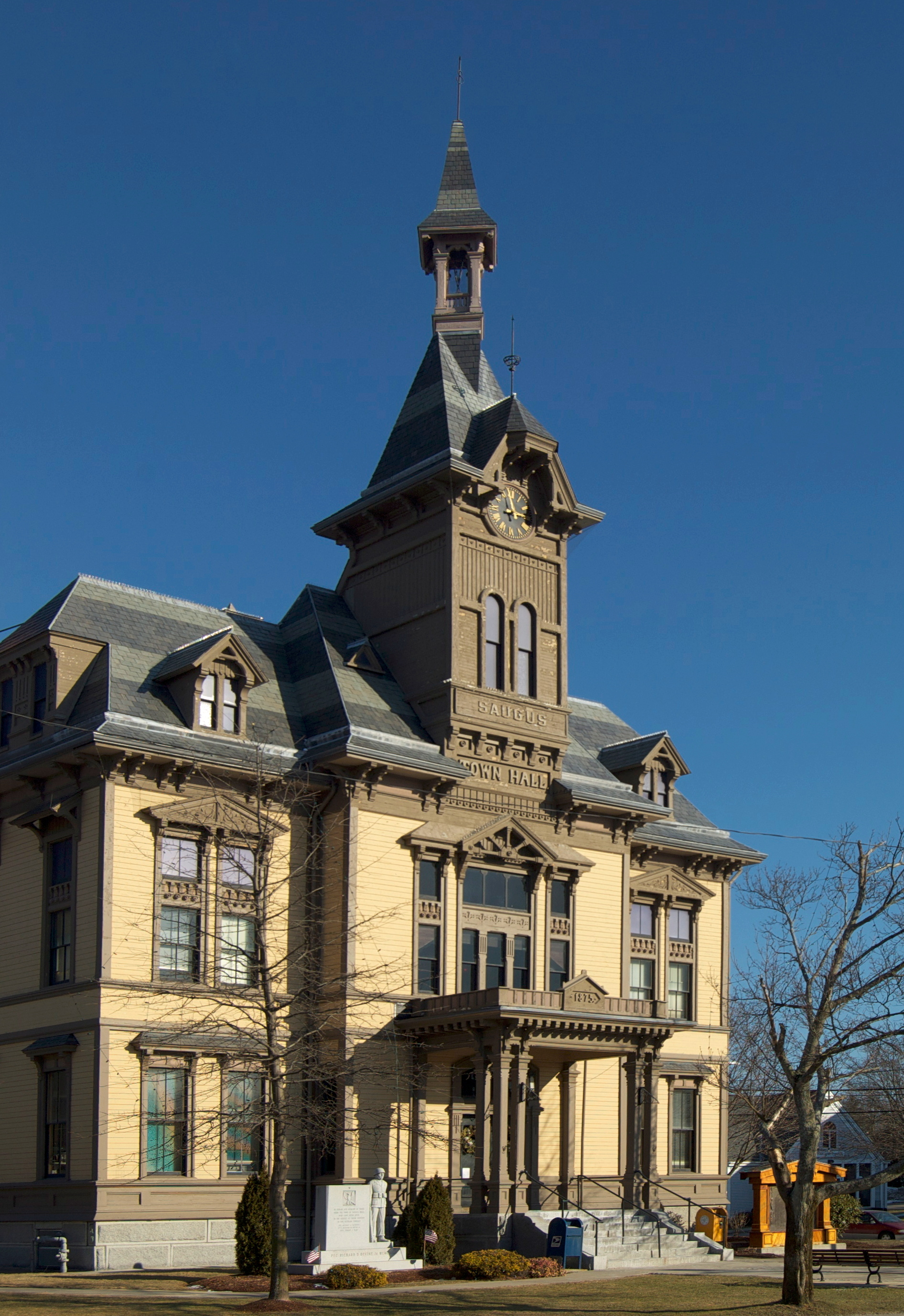
The first town hall was built in 1837. It was built with $2,000 of the United States revenue surplus distributed by President Andrew Jackson. It is currently an American Legion hall. In 1875 the town built its second and current town hall on Central Street. The construction of the town hall put the city in a $50,000 debt. For this and other reasons the neighborhood of East Saugus sought to be set of from Saugus and annexed to the city of Lynn. East Saugus was unable to get a bill in both houses of state legislature and the issue was dropped after the town appropriated $5,000 for the laying of water pipes through East Saugus.[4]
Saugus' first post office was established in 1832 in East Saugus. In 1858 two more were established - one in Saugus Center and one in Cliftondale.[4] Now only the Cliftondale post office remains in Saugus.
In 1805 the Newburyport Turnpike (now U.S. 1) was built. About four miles of this road was built in Saugus. At first the turnpike was considered a mistake, as it was built over hills and swamps and grass soon grew over the road bed. From 1840 to 1846, the tolls were discontinued and it became a public highway.[4] The invention of the automobile resulted in an increase of traffic on the Turnpike. In 1933 the road was widened and an overpass was added to separate the traffic on Route 1 and Main Street. In the 1950s new businesses began moving to Route 1. Today the businesses along Route 1 generate millions in dollars for Saugus.[5]
Passenger trains ran through Saugus from 1854 until the mid-1950s. The Eastern Railroad, Boston and Maine Railroad, and Grand Junction Railroad all ran on the Saugus Branch Railroad at some point. The Saugus Branch included three stations, one in Saugus Center, one in Cliftondale, and one in Pleasant Hills.[5]
Saugus was also home to the Franklin Trotting Park harness racing,[6] also known as the Saugus Racetrack[7] or Saugus Race Course.[8] The racetrack and adjacent hotel opened in 1870. The half-mile oval track and the four story hotel and grandstand was a big attraction. It closed in 1905 after local citizens complained about the questionable patrons that the racetrack attracted. After the racetrack's closing, the area was used to host fairs and circuses.[9]
In 1912 the racetrack became an airfield.[9] The airfield saw the first airmail delivery in New England on May 30, 1912.[7] It was later named Atwood Aviation Park after Harry Atwood the pilot of the historic delivery.[5] Pioneer aviators Ruth Bancroft Law[10] and Lincoln J. Beachey[5] flew at Saugus. The airport closed in the 1920s.[9]
In addition to serving as a horse track and airfield the area was also used for fairs, circuses, motorcycle racing, and auto racing.[9] In 1940 the property was offered by its owner Godfrey Lowell Cabot to the United States Navy for use as an airship base.[11] The base was never built and the land remained privately owned until 1990 when it was given to the Metropolitan District Commission.[9]
Laurence G. Hanscom a pilot, aviation enthusiast, State House reporter for the Worcester Telegram Gazette, and namesake of Hanscom Air Force Base and Hanscom Field was killed in a plane crash while performing stunt maneuvers over marshland in Saugus on February 9, 1941.[12]
Saugus is home to the oldest barber shop in the United States. The over 100 year old George's Barber Shop is located in the Cliftondale section of Saugus.
In October 1975, the first commercially-successful incineration plant in the U.S. was built in Saugus, Massachusetts by Wheelabrator Technologies, and is still in operation today.[13]
In 1989, the attempted murder of Frank Salemme by Angelo Mercurio took place in Saugus.
In recent years, the Town Hall has been renovated, a new public library was built, the Saugus River has been dredged, and the community has increased its commitment to recycling. Today, Route 1 in Saugus boasts a diverse mix of businesses, restaurants, and recreational activities.
Geography and Transportation
According to the United States Census Bureau, the town has a total area of 11.8 square miles (30.4 km²), of which, 11.0 square miles (28.5 km²) of it is land and 0.8 square miles (2.0 km²) of it (6.55%) is water. The town lies just inland from Massachusetts Bay, divided from the ocean by the Point of Pines neighborhood of Revere. The southern end of town is dominated by Rumney Marsh, which lies along the Pines River, a tributary of the Saugus River. The Saugus River flows through town, and is fed by several brooks. There are several ponds within town, including parts of Birch Pond, Hawkes Pond and Walden Pond (not related to a pond of the same name in Concord, Massachusetts). Part of the Lynn Woods Reservation, and most of the Breakheart Reservation and Rumney Marsh Reservation lie within town.
Saugus is divided into several neighborhood villages, including Saugus Center, East Saugus, North Saugus, Pleasant Hill, Lynnhurst, Oaklandvale and Cliftondale. Of these, the majority of the town's population resides in Lynnhurst, Pleasant Hills, Cliftondale, East Saugus and Saugus Center; Oakland Vale and North Saugus are much less densely populated. The town lies at the southern end of Essex County (though it is not the southernmost town in the county; Nahant extends just south of the town). The town is bordered by Lynnfield to the north, Lynn to the east, Revere (in Suffolk County) to the south, and Melrose and Wakefield to the west, in Middlesex County. The town also shares a common point with the town of Malden, where it also meets Melrose and Revere. Saugus lies eight miles southwest of Salem, nine miles northeast of Boston, 24 miles southwest of Cape Ann and twenty miles south-southeast of the New Hampshire state line.
U.S. Route 1 passes through town along a divided highway, with five exit ramps throughout town. This stretch of Route 1, though not a full controlled access highway (it is lined with a major shopping district, including the Square One Mall), is a major commuter route out of Boston, heading towards the intersection of Interstate 95 and Route 128 in Lynnfield. The route is also shared by a 3/4-mile long concurrency with Route 129, which passes through North Saugus before joining Route 1 to head northward into Lynnfield. Route 99 terminates at Route 1 as well, in the southern end of town. Route 107 also passes through the town as the Salem Turnpike through the Rumney Marsh, crossing the Saugus River into Lynn over the Fox Hill Bridge.
The Newburyport/Rockport Line of the MBTA Commuter Rail passes through the southeast corner of town, between two stations in Lynn (at the GE plant and at Central Square) and one in nearby Chelsea. The Blue Line of the MBTA's subway line terminates in Revere; there has been talk of extending the subway into Lynn. Saugus is also served by several lines of the MBTA's bus service, linking the town with nearby train lines. The nearest airport is Boston's Logan International Airport.
Demographics
Historical populations Year Pop. ±% 1850 1,552 — 1860 2,024 +30.4% 1870 2,247 +11.0% 1880 2,625 +16.8% 1890 3,673 +39.9% 1900 5,084 +38.4% 1910 8,047 +58.3% 1920 10,874 +35.1% 1930 14,700 +35.2% 1940 14,825 +0.9% 1950 17,162 +15.8% 1960 20,666 +20.4% 1970 25,110 +21.5% 1980 24,746 −1.4% 1990 25,549 +3.2% 2000 26,078 +2.1% 2001* 26,315 +0.9% 2002* 26,319 +0.0% 2003* 26,264 −0.2% 2004* 26,333 +0.3% 2005* 26,439 +0.4% 2006* 26,663 +0.8% 2007* 26,961 +1.1% 2008* 27,418 +1.7% 2009* 27,940 +1.9% 2010 26,628 −4.7% * = population estimate.
Source: United States Census records and Population Estimates Program data.[14][15][16][17][18][19][20][21][22][23]As of the census of 2010, there were 26,628 people, 10,318 households, and 7,144 families residing in the town. The population density was 2,373.7 people per square mile (916.5/km²). The racial makeup of the town was 91.9% White, 4.0% Hispanic or Latino, 2.7% Asian, 2.1% Black or African American, 0.1% Native American, 0.0% Pacific Islander, 1.6% from other races, and 1.6% from two or more races.
There were 10,318 households out of which 17.1% had children under the age of 18 living with them, 53.0% were married couples living together, 11.5% had a female householder with no husband present, 4.7% had a male householder with no wife present, and 30.8% were non-families. The average household size was 2.55 and the average family size was 3.09.
In the town the population was spread out with 4.5% under the age of 5, 5.2% from 5 to 9, 5.7% from 10 to 14, 5.9% from 15 to 19, 5.6% from 20 to 24, 5.6% from 25 to 29, 5.5% from 30 to 34, 6.4% from 35 to 39, 7.3% from 40 to 44, 8.1% from 45 to 49, 8.4% from 50 to 54, 7.5% from 55 to 59, 6.9% from 60 to 64, 4.9% from 65 to 69, 3.8% from 70 to 74, 3.6% from 75 to 79, 2.9% from 80 to 84, and 2.3% who were 85 years of age or older. The median age was 43.9 years.
The median income for a household in the town was $55,301, and the median income for a family was $65,782. Males had a median income of $43,219 versus $32,783 for females. The per capita income for the town was $25,524. About 3.1% of families and 4.2% of the population were below the poverty line, including 4.5% of those under age 18 and 7.2% of those age 65 or over.
Media
Saugus Community Television, Inc. more commonly known as SCTV is a Public-access television station and a non-profit organization established to provide local television programing to the community. SCTV broadcasts to Saugus Comcast cable subscribers on channel 8 (Public-access), channel 9 (Government), and channel 10 (Educational).
Saugus is home to two newspapers; The Saugus Advertiser and The Saugus Advocate.
Points of interest
- Belden Bly Bridge
- Boardman House
- Breakheart Reservation
- Camp Nihan
- Kowloon Restaurant
- Pranker's Pond
- Rumney Marsh
- Saugus Iron Works National Historic Site
- Saugus River
- Saugus Town Hall
- Square One Mall
- World Series Park
Notable residents
Main article: List of people from Saugus, MassachusettsMovies and television shows filmed in Saugus
- American Playhouse episode Three Sovereigns for Sarah (1985) [24]
- The Joneses (2009) [25]
- Furry Vengeance (2010) [26]
See also
- 2003 Little League World Series
- J. J. Jameson
- Linden on the Saugus Branch
- North Shore
- MBTA Buses in Saugus, Lynn & Salem
- USS Saugus (1863)
- USS Saugus (LSV-4)
- USS Saugus (YTB-780)
References
- ^ United States Census Office. Census reports Tenth census. June 1, 1880. 18. pp. 242–243. http://books.google.com/books?id=UmZ3ILOF9CoC&pg=PA242&dq#v=onepage&q&f=false. Retrieved 2011-03-06.
- ^ http://www.nps.gov/sair Saugus Iron Works National Historic Site
- ^ Reflections in Bullough's Pond, Diana Muir, University Press of New England, p.99.
- ^ a b c d Wilbur F. Newhall, Esq. (1888). History of Essex County, Massachusetts: With Biographical Sketches of Many of Its Pioneers and Prominent Men, Volume 1. J. W. Lewis & Co.. http://books.google.com/books?id=15Q6AQAAIAAJ&pg=PA393.
- ^ a b c d Norman E. Down (1997). Images of America: Saugus. Arcadia Publishing. ISBN 0-7524-0469-5.
- ^ "Left His Creditors Behind". The New York Times. February 19, 1889. http://select.nytimes.com/gst/abstract.html?res=FA0F13FD3C5F15738DDDAB0A94D9415B8984F0D3. Retrieved 2011-03-06.
- ^ a b "Atwood as Aerial Mail Man". Boston Evening Transcript. May 31, 1912. http://news.google.com/newspapers?id=1UhfAAAAIBAJ&sjid=nFQNAAAAIBAJ&pg=5816,5928567. Retrieved 2011-03-06.
- ^ "To Purify Amateur Sport.". Boston Evening Transcript. November 11, 1896. http://news.google.com/newspapers?id=PAc0AAAAIBAJ&sjid=miMIAAAAIBAJ&pg=5036,896044&dq. Retrieved 2011-03-06.
- ^ a b c d e http://www.nmca.org/Nmca98-4.htm RUMNEY MARSH, PARK AVENUE RESTORATIONS PROJECT
- ^ Heroines of the Sky. Doubleday, Doran & Company, Inc.. 1970.
- ^ "Saugus Land Offered For U.S. Airship Base". Christian Science Monitor. November 21, 1940.
- ^ "Two Killed When Plane Nose Dives". The Hartford Courant. February 10, 1941.
- ^ Waste-to-Energy: Less Environmental Impact than Almost Any Other Source of Electricity, Integrated Waste Services Association homepage
- ^ "TOTAL POPULATION (P1), 2010 Census Summary File 1, All County Subdivisions within Massachusetts". United States Census Bureau. http://factfinder2.census.gov/bkmk/table/1.0/en/DEC/10_SF1/P1/0400000US25.06000. Retrieved September 13, 2011.
- ^ "Massachusetts by Place and County Subdivision - GCT-T1. Population Estimates". United States Census Bureau. http://factfinder.census.gov/servlet/GCTTable?_bm=y&-geo_id=04000US25&-_box_head_nbr=GCT-T1&-ds_name=PEP_2009_EST&-_lang=en&-format=ST-9&-_sse=on. Retrieved July 12, 2011.
- ^ "1990 Census of Population, General Population Characteristics: Massachusetts". US Census Bureau. December 1990. Table 76: General Characteristics of Persons, Households, and Families: 1990. 1990 CP-1-23. http://www.census.gov/prod/cen1990/cp1/cp-1-23.pdf. Retrieved July 12, 2011.
- ^ "1980 Census of the Population, Number of Inhabitants: Massachusetts". US Census Bureau. December 1981. Table 4. Populations of County Subdivisions: 1960 to 1980. PC80-1-A23. http://www2.census.gov/prod2/decennial/documents/1980a_maABC-01.pdf. Retrieved July 12, 2011.
- ^ "1950 Census of Population". Bureau of the Census. 1952. Section 6, Pages 21-10 and 21-11, Massachusetts Table 6. Population of Counties by Minor Civil Divisions: 1930 to 1950. http://www2.census.gov/prod2/decennial/documents/23761117v1ch06.pdf. Retrieved July 12, 2011.
- ^ "1920 Census of Population". Bureau of the Census. Number of Inhabitants, by Counties and Minor Civil Divisions. Pages 21-5 through 21-7. Massachusetts Table 2. Population of Counties by Minor Civil Divisions: 1920, 1910, and 1920. http://www2.census.gov/prod2/decennial/documents/41084506no553ch2.pdf. Retrieved July 12, 2011.
- ^ "1890 Census of the Population". Department of the Interior, Census Office. Pages 179 through 182. Massachusetts Table 5. Population of States and Territories by Minor Civil Divisions: 1880 and 1890. http://www2.census.gov/prod2/decennial/documents/41084506no553ch2.pdf. Retrieved July 12, 2011.
- ^ "1870 Census of the Population". Department of the Interior, Census Office. 1872. Pages 217 through 220. Table IX. Population of Minor Civil Divisions, &c. Massachusetts. http://www2.census.gov/prod2/decennial/documents/1870e-05.pdf. Retrieved July 12, 2011.
- ^ "1860 Census". Department of the Interior, Census Office. 1864. Pages 220 through 226. State of Massachusetts Table No. 3. Populations of Cities, Towns, &c.. http://www2.census.gov/prod2/decennial/documents/1860a-08.pdf. Retrieved July 12, 2011.
- ^ "1850 Census". Department of the Interior, Census Office. 1854. Pages 338 through 393. Populations of Cities, Towns, &c.. http://www2.census.gov/prod2/decennial/documents/1850c-11.pdf. Retrieved July 12, 2011.
- ^ "IMDB.com - "American Playhouse" Three Sovereigns for Sarah (1985)". IMDB. http://www.imdb.com/title/tt0090164/locations. Retrieved 2011-03-06.
- ^ "IMDB.com - Filming locations for The Joneses". IMDB. http://www.imdb.com/title/tt1152830/locations. Retrieved 2011-03-06.
- ^ Chris Stevens. "Saugus' Breakheart playing perfect host to 'Furry' filming". The Daily Item. http://www.itemlive.com/articles/2009/08/21/news/news04.txt. Retrieved 2011-03-06.
External links
- Official Town Government Website
- Saugus.COM Community Information
- Saugus.net: Assorted Saugus Information
- Town of Saugus, MA. Essex County
- The Saugus Historical Society
Municipalities and communities of Essex County, Massachusetts Cities Amesbury | Beverly | Gloucester | Haverhill | Lawrence | Lynn | Methuen | Newburyport | Peabody | Salem
Towns Andover | Boxford | Danvers | Essex | Georgetown | Groveland | Hamilton | Ipswich | Lynnfield | Manchester-by-the-Sea | Marblehead | Merrimac | Middleton | Nahant | Newbury | North Andover | Rockport | Rowley | Salisbury | Saugus | Swampscott | Topsfield | Wenham | West Newbury
CDPs Other
villagesAnnisquam | Ballardvale | Beverly Farms | Bradford | Byfield | Clifton | Plum Island
Categories:- Saugus, Massachusetts
- Populated coastal places in Massachusetts
- Populated places established in 1629

Wikimedia Foundation. 2010.