- North Petherton
-
Coordinates: 51°05′28″N 3°00′47″W / 51.091°N 3.013°W
North Petherton 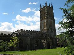
Church of St Mary, North Petherton
 North Petherton
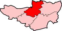
North Petherton shown within SomersetPopulation 5,189 [1] OS grid reference ST290329 District Sedgemoor Shire county Somerset Region South West Country England Sovereign state United Kingdom Post town BRIDGWATER Postcode district TA6 Dialling code 01278 Police Avon and Somerset Fire Devon and Somerset Ambulance South Western EU Parliament South West England UK Parliament Bridgwater and West Somerset List of places: UK • England • Somerset North Petherton is a small town and civil parish in Somerset, England, situated on the edge of the eastern foothills of the Quantocks, and close to the edge of the Somerset Levels.[2] The town has a population of 5,189.[1] The parish includes Hamp, Melcombe, Woolmersdon and Huntworth.
Dating from at least the 10th century and an important settlement in Saxon times,[2] North Petherton became a town only in the late 20th century, until then claiming to be the largest village in England.
A former market and administrative centre, North Petherton is now largely a dormitory town for workers in Bridgwater, 3 miles (5 km) to the north east, and Taunton, 8 miles (13 km) to the south west. The centre of the town is designated an Area of High Archaeological Potential (AHAP), and a number of buildings have been given listed building status.
Contents
Toponymy
The town is mentioned in the Domesday Book as Nortperet. The name derives from the area's location to the north side of the River Parrett, from the Latin Paradæ 'barge' and from the Old English nor tun.[3]
History
Long before the Norman Conquest, during Saxon times North Petherton was at the centre of a large royal estate, located on one of the historic communication routes through Somerset, and was both an important centre and the meeting place for the Hundred of North Petherton[2] although the Petherton limit tithing of North Petherton was in the Hundred of Andersfield from the 1670s.[4]
At the time of the Norman invasion the Hundred covered a large area corresponding, today, roughly to a north–south corridor along the M5 motorway from Junction 25 near Taunton, to north of Junction 23 at Stretcholt, and east–west from Athelney to Goathurst. The Parish of North Petherton continues to be one of the largest in Somerset to this day.[2]
Henry II expanded the royal estate into the Royal Forest (hunting ground) of North Petherton,[2] which continued to exist until the 17th century. Geoffrey Chaucer (~1343-1400), author of The Canterbury Tales was appointed Deputy Forester of the Royal Forest of North Petherton towards the end of his life.[5] The Royal Forest was probably similar in area to the Saxon Hundred of North Petherton.[6] According to the late 13th-century Hundred Rolls, King Henry II of England (d. 1189) gave William of Wrotham lands at North Petherton.[7]
The town itself it thought to have developed around the minster which, it is supposed, was on the same site as the current church.[2] There is archaeological evidence indicating that there were timber buildings to the west of the church in the late Saxon period, and it is suspected that the remains of the Saxon settlement may continue to lie beneath the town centre.[2] Excavations to the west of the church, on what is now the Community Centre site, revealed a 14th century cemetery, which may have been used for victims of the plague, as well as indicting that the area was redeveloped in the late middle ages.[2] It is thought that there may have been a mint in the town during the 10th or 11th century, and a charter to hold a market was granted in 1318, although it is thought that the market predated this.[2] A shire hall, courthouse and guildhall are known to have exited and were probably located north of the church.[2]
A minor skirmish of the English Civil War took place in August 1644 outside what was then the cornhill, now the area of Fore Street between the Community Centre and the former George Inn.
The Alfred Jewel, an object about 2.5-inch (64 mm) long, made of filigree gold, cloisonné-enamelled and with a rock crystal covering, was found in 1693 at Petherton Park, North Petherton.[8] Believed to have been owned by Alfred the Great[5] it is thought to have been the handle for a pointer that would have fit into the hole at its base and been used while reading a book. It is inscribed, "AELFRED MEC HEHT GEWYRCAN," ("Alfred had me made"). It may be one of the "aestels" Alfred had sent to each bishopric with a copy of his translation of Pope Gregory the Great's book Pastoral Care. A replica of the jewel can be found in the church of St Mary.
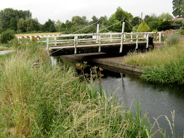
 Crossways Swing Bridge at North Newton
When the Bridgwater and Taunton Canal was opened in 1827 it joined the River Parrett by a lock at Huntworth, where a basin was constructed, but in 1841 the canal was extended to a floating harbour in Bridgwater, and the Huntworth link was filled in.[9] The canal and river were not re-connected at this point when the canal was restored, because the Parrett is by then a salt water river laden with silt, whereas the canal contains fresh water. Not only is there a risk of silt entering the canal,[10] but the salt water cannot be allowed to contaminate the fresh, as the canal is still used for the transport of drinking water for Bridgwater's population.[11] The Crossways Swing Bridge over the canal in the parish was built in 1827 by John Rennie. It is a wooden bridge which rotates on steel ball-bearings in a circular track. It is now the only bridge retaining its mechanism and is a very early example of the use of ball bearings in this way. It has been designated as a Grade II listed building.[12] The Higher and Lower Maunsel locks on the canal are either side of the Maunsel bridge which carries the A361.[13] The stone Coxhill road bridge dates from the same time.[14]
North Petherton was the first town in England (and one of the few ever) to be lit by acetylene gas lighting, supplied by the North Petherton Rosco Acetylene Company (dating from at least 1898), operating from a plant in Mill Lane which has since been demolished to form a car park for the local doctor's surgery. The adjacent church was the first building supplied, no doubt acting as a useful advert. Street lights were provided in 1906. Acetylene was replaced in 1931 by coal gas produced in Bridgwater, as well as by the provision of an electricity supply.[6]
In 1926 the Bridgwater Beam Wireless Station was opened north east of the town. It was the UK receiving station for Marconi's UK-to-Canada Beam Wireless Service, (part of the Imperial Wireless Chain,) the first transoceanic shortwave wireless telegraph service in the world and operated until 2002.
In 1984 North Petherton was provided with a small public library. As a result of a revitalised fund-raising campaign (originally begun decades earlier), this was followed a few years later by the construction of a Community Centre, opened in in 1987, which was extended in 1991.[15]
Governance
The Civil parish of North Petherton includes the villages of North Newton (on the route of the Bridgwater and Taunton Canal) and Northmoor Green (also known as Moorland) in the Somerset Levels, as well as a number of other smaller settlements. Despite several reductions in size, with land redesignated to neighbouring parishes, North Petherton remains one of the largest parishes in Somerset at 43 km2 (16.6 sq mi), and the largest in Sedgemoor.[2]
The parish council has responsibility for local issues, including setting an annual precept (local rate) to cover the council’s operating costs and producing annual accounts for public scrutiny. The parish council evaluates local planning applications and works with the local police, district council officers, and neighbourhood watch groups on matters of crime, security, and traffic. The parish council's role also includes initiating projects for the maintenance and repair of parish facilities, as well as consulting with the district council on the maintenance, repair, and improvement of highways, drainage, footpaths, public transport, and street cleaning. Conservation matters (including trees and listed buildings) and environmental issues are also the responsibility of the council.
The village falls within the Non-metropolitan district of Sedgemoor, which was formed on 1 April 1974 under the Local Government Act 1972, having previously been part of Bridgwater Rural District,[16] which is responsible for local planning and building control, local roads, council housing, environmental health, markets and fairs, refuse collection and recycling, cemeteries and crematoria, leisure services, parks, and tourism. Somerset County Council is responsible for running the largest and most expensive local services such as education, social services, the library, roads, public transport, trading standards, waste disposal and strategic planning, although fire, police and ambulance services are provided jointly with other authorities through the Devon and Somerset Fire and Rescue Service, Avon and Somerset Constabulary and the South Western Ambulance Service.
It is also part of the Bridgwater and West Somerset county constituency represented in the House of Commons of the Parliament of the United Kingdom. It elects one Member of Parliament (MP) by the first past the post system of election, and part of the South West England constituency of the European Parliament which elects seven MEPs using the d'Hondt method of party-list proportional representation.
Geography
North Petherton is situated on one of the historic communication routes through Somerset, and a turnpike through the town was opened between Bridgwater and Taunton in the 1730s.[17] The opening of the nearby M5 motorway in the 1970s which relieved major traffic jams on the A38 through the town, also added to the attraction of the town for commuters and has consequently led to the construction of several new housing estates. The town lies on the route of the Macmillan Way West long-distance footpath.
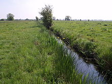 A drain on North Moor
South east of the town near Lyng, on the opposite side of the M5 motorway but within the parish is North Moor, a 676.3 hectare biological Site of Special Scientific Interest. North Moor is a nationally important grazing marsh and ditch system on the Somerset Levels and Moors. A range of neutral grassland types supporting common and scarce plants has developed mainly due to variations in soils and management practices. Aquatic plant communities are exceptionally diverse with good populations of nationally scarce species. The site has special interest in its bird life.[18]
Climate
Along with the rest of South West England, North Petherton has a temperate climate which is generally wetter and milder than the rest of the country.[19] The annual mean temperature is approximately 10 °C (50.0 °F). Seasonal temperature variation is less extreme than most of the United Kingdom because of the adjacent sea temperatures. The summer months of July and August are the warmest with mean daily maxima of approximately 21 °C (69.8 °F). In winter mean minimum temperatures of 1 °C (33.8 °F) or 2 °C (35.6 °F) are common.[19] In the summer the Azores high pressure affects the south-west of England, however convective cloud sometimes forms inland, reducing the number of hours of sunshine. Annual sunshine rates are slightly less than the regional average of 1,600 hours.[19] In December 1998 there were 20 days without sun recorded at Yeovilton. Most the rainfall in the south-west is caused by Atlantic depressions or by convection. Most of the rainfall in autumn and winter is caused by the Atlantic depressions, which is when they are most active. In summer, a large proportion of the rainfall is caused by sun heating the ground leading to convection and to showers and thunderstorms. Average rainfall is around 700 mm (28 in). About 8–15 days of snowfall is typical. November to March have the highest mean wind speeds, and June to August have the lightest winds. The predominant wind direction is from the south-west.[19]
Economy
North Petherton used to be a market town, with the right to hold a market having been granted in 1318, along with the right to an annual fair.[2]
In the past the town hosted a Starkey Knight and Ford brewery on Fore Street (demolished in the late 1960s), several maltings, a light engineering works (Trig Engineering, since moved to the Huntworth Business Park adjacent to the nearby Junction 24 of the M5 motorway), and in earlier times at least 7 watermills.
Basket making and the manufacture of associated products including wicker furniture, was also a significant industry, at one time employing over 100 people in small factories and homes, until its decline in the second half of the 20th century. The products were distributed nationally via the railway station at Bridgwater. Nearby King's Cliff formerly provided a source of building stone for the town dating from at least Medieval times. The production of cloth and leather goods also used to take place in the town, the former being commemorated in the name of the road known as Dyer's Green.
The extensive cider orchards that used to surround much of the town in the 19th century had largely disappeared by the end of the 20th, by which time local employment was largely restricted to service businesses and farming.
A new £100 m Regional Agricultural Business Centre, including an extensive Cattle Market and Dairy opened just beyond the outskirts of the town in 2007, following construction which began in 2006.[20][21] This replaced the cattle markets in both Taunton and Bridgwater.
Education
 North Petherton junior school
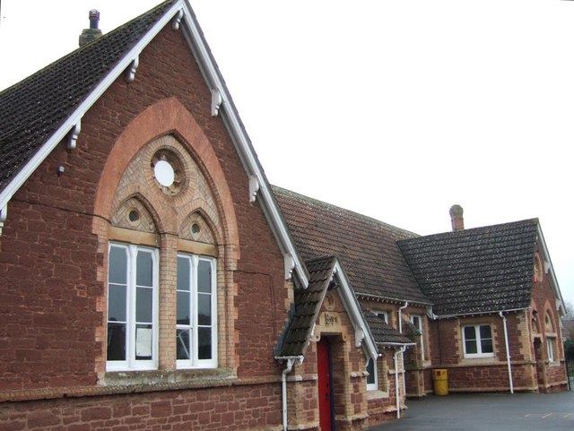
North Petherton has two schools, North Petherton juniors and North Petherton infants, however they have been joined together to form one school, North Petherton Primary School.
Secondary schools in nearby Bridgwater include: Robert Blake Science College, Brymore School, Chilton Trinity Technology College, East Bridgwater Community School which was previously known as Sydenham School and is a Performing and Visual Arts College,[22] and Haygrove School which has specialist Language College status.[23] Special schools in the town include: Elmwood Special School, New Horizon Centre School and Penrose School.
Further Education is provided by Bridgwater College which was formerly Bridgwater Technical School.[24]
Religious sites
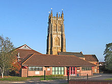 The community centre with St Mary's church tower behind
The town has the minster church of St Mary the Virgin, with a highly decorated tower which, at 120 feet (37 m) high, is claimed to be one of the tallest towers in the West Country. The building is mainly dated from the 15th century, with a minstrel gallery from 1623, a peal of six bells, and a clock built in Bridgwater in 1807. It has been designated by English Heritage as a grade I listed building.[25] A specification of the organ can be found on the National Pipe Organ Register.
The Church of St Peter has a tower which may be of Saxon origin which was altered in 1635. The rest of the church was completely rebuilt for Rev. Thomas Eaton in 1885. It is Grade II* listed.[26]
The Church of St. Michael has Norman origins and has seen various restorations since. It was last restored and extended in 1868 for Slade family of Maunsel House.[27]
In the cemetery is a 19th century combined Non-conformist and Anglican Mortuary Chapel.[28]
Culture
The annual North Petherton Carnival is part of the West Country Carnival circuit, and takes place in November, on the Saturday after the first Thursday in November. The date of the first Carnival at Bridgwater is the preceding Friday, featuring most of the same participants.[29]
The Walnut Tree (rebranded in the 1970s from the Clarence Hotel, and before that as the New Inn) which now provides the only hotel accommodation in the town, was formerly in competition with the George Hotel (now closed), where monthly petty sessions (court hearings) were formerly held.
See also
References
- ^ a b "Parish Population Statistics for Sedgemoor". ONS Census 2001. Somerset County Council. http://www.webcitation.org/5lRyCSu4c. Retrieved 17 December 2009.
- ^ a b c d e f g h i j k l Gathercole, Clare. "North Petherton". The Somerset Urban Archaeological Survey. Somerset County Council. http://www1.somerset.gov.uk/archives/hes/downloads/EUS_North_PethertonText.pdf. Retrieved 23 May 2010.
- ^ Robinson, Stephen (1992). Somerset Place Names. Dovecote Press. ISBN 1874336032.
- ^ R W Dunning, C R Elrington (Editors), A P Baggs, M C Siraut (1992). "North Petherton: Local government". A History of the County of Somerset: Volume 6: Andersfield, Cannington, and North Petherton Hundreds (Bridgwater and neighbouring parishes). Institute of Historical Research. http://www.british-history.ac.uk/report.aspx?compid=18688. Retrieved 13 October 2011.
- ^ a b "Local History". North Petherton. http://www.nthpetherton.co.uk/history.htm. Retrieved 19 November 2007.
- ^ a b "North Petherton". British History Online. http://www.british-history.ac.uk/report.aspx?compid=18684. Retrieved 19 November 2007.
- ^ Golding "Wrotham, William of (d. 1217/18)" Oxford Dictionary of National Biography
- ^ "Replicas of the Alfred Jewel". The Anglo Saxon Index, Trinity College, Cambridge. http://www.trin.cam.ac.uk/sdk13/AlfJewel.html. Retrieved 18 September 2007.
- ^ Charles Hadfield, (1967), The Canals of South West England, David and Charles, ISBN 0-7153-4176-6
- ^ Taunton Civic Society, Taunton's Waterways
- ^ Bridgwater Docks, (photographic record)
- ^ "Crossways Swing Bridge". Images of England. English Heritage. http://www.imagesofengland.org.uk/Details/Default.aspx?id=269353. Retrieved 4 August 2010.
- ^ "Higher Maunsell Lock No 4 and Higher Maunsell Bridge". Images of England. English Heritage. http://www.imagesofengland.org.uk/Details/Default.aspx?id=269437. Retrieved 4 August 2010.
- ^ "Coxhill Bridge". Images of England. English Heritage. http://www.imagesofengland.org.uk/Details/Default.aspx?id=269435. Retrieved 4 August 2010.
- ^ "History". North Petherton: North Petherton Community Centre. 2011. http://www.npcommunitycentre.org/history. Retrieved 11 September 2011.
- ^ "A Vision of Britain Through Time : Bridgwater Rural District". http://www.visionofbritain.org.uk/relationships.jsp?u_id=10025527&c_id=10001043.
- ^ "Eighteenth-century Turnpike road, East Brent to Thurloxton". Somerset Historic Environment Record. Somerset County Council. http://webapp1.somerset.gov.uk/her/details.asp?prn=24587. Retrieved 4 August 2010.
- ^ "SSSI citation sheet for North Moor". English Nature. http://www.english-nature.org.uk/citation/citation_photo/1002395.pdf. Retrieved 4 August 2010.
- ^ a b c d "South West England: climate". Met Office. http://www.metoffice.gov.uk/climate/uk/sw/. Retrieved 14 March 2010.
- ^ "£100m agricultural centre begins". Bridgwater Mercury. http://www.falmouthpacket.co.uk/archive/2006/08/15/Bridgwater+News+%28bm_news_bridgwater%29/877966.__100m_agricultural_centre_begins/. Retrieved 11 November 2010.
- ^ "£50 m agricultural centre to open". BBC News (BBC). 22 December 2005. http://news.bbc.co.uk/1/hi/england/somerset/4553340.stm. Retrieved 4 August 2010.
- ^ "East Bridgwater Community School". Ofsted. http://www.ofsted.gov.uk/oxedu_providers/full/(urn)/123880. Retrieved 30 March 2009.
- ^ "Haygrove School". Ofsted. http://www.ofsted.gov.uk/oxedu_providers/full/(urn)/123882. Retrieved 30 March 2009.
- ^ "Pen Portrait". Bridgwater College. http://www.bridgwater.ac.uk/content.php?sec2id=46. Retrieved 13 March 2010.
- ^ "Church of St. Mary". Images of England. http://www.imagesofengland.org.uk/details/default.aspx?id=269339. Retrieved 19 November 2007.
- ^ "Church of St. Peter". Images of England. English Heritage. http://www.imagesofengland.org.uk/Details/Default.aspx?id=269322. Retrieved 23 May 2010.
- ^ "Church of St. Michael". Images of England. English Heritage. http://www.imagesofengland.org.uk/Details/Default.aspx?id=269370. Retrieved 4 August 2010.
- ^ "Combined Non-conformist and Anglican Mortuary Chapel". Images of England. English Heritage. http://www.imagesofengland.org.uk/Details/Default.aspx?id=269365. Retrieved 4 August 2010.
- ^ "North Petherton Carnival". North Petherton Carnival. http://www.northpethertoncarnival.co.uk/. Retrieved 23 May 2010.
External links
Towns, villages and hamlets in the Sedgemoor district of Somerset, England  Ashcott · Axbridge · Badgworth · Bawdrip · Berrow · Brean · Brent Knoll · Bridgwater · Broomfield · Burnham-on-Sea · Burtle · Cannington · Catcott · Chapel Allerton · Cheddar · Chedzoy · Chilton Polden · Chilton Trinity · Compton Bishop · Cossington · Durleigh · East Brent · Huntspill · Edington · Edithmead · Enmore · Fiddington · Goathurst · Greinton · Highbridge · Lympsham · Lyng · Mark · Middlezoy · Moorlinch · Nether Stowey · North Petherton · Othery · Otterhampton · Over Stowey · Pawlett · Puriton · Shapwick · Shipham · Spaxton · Stawell · Stockland Bristol · Thurloxton · Weare · Wedmore · Wembdon · Westonzoyland · WoolavingtonCategories:
- Civil parishes in Somerset
- Market towns in Somerset
- Towns in Sedgemoor


Wikimedia Foundation. 2010.