- Durleigh
-
Coordinates: 51°07′23″N 3°02′13″W / 51.123°N 3.037°W
Durleigh 
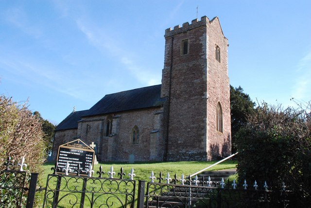
Durleigh Church
 Durleigh
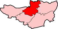
Durleigh shown within SomersetPopulation 609 [1] OS grid reference ST275365 District Sedgemoor Shire county Somerset Region South West Country England Sovereign state United Kingdom Post town BRIDGWATER Postcode district TA5 2A Dialling code 01278 Police Avon and Somerset Fire Devon and Somerset Ambulance South Western EU Parliament South West England UK Parliament Bridgwater and West Somerset List of places: UK • England • Somerset Durleigh is a village and civil parish on the outskirts of Bridgwater in the Sedgemoor district of Somerset, England. According to the 2001 Census, it had a population of 609.[1] Its nearest town is Bridgwater, which lies approximately 1.6 miles (2.6 km) north-east from the village.
The village lies on Durleigh brook, a tributary of the River Parrett, which was dammed in 1938 to form Durleigh reservoir.
Contents
History
The name Durleigh means wood frequented by deer.[2]
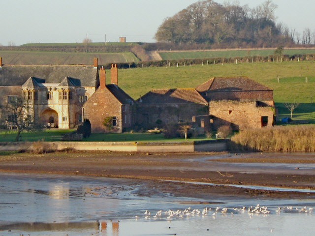
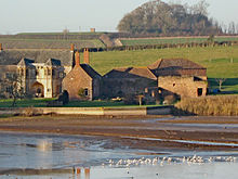 West Bower Manor
Durleigh was part of the hundred of Andersfield.[3]
West Bower Manor (also known as Durleigh Manor) is all that remains of a large manorial property, the majority of which has been demolished. Parts of the building date from the 15th century though the core of the fabric may even be earlier, further parts were built in the 17th and 19th centuries.[4] It was the seat of the historical estate of "West Bower" (Bower Delamere) once held by Edward Seymour, 1st Duke of Somerset, the brother of Jane Seymour, Henry the VIII`s Queen.[5][6]
Eight people from the parish were accused of complicity in the Monmouth Rebellion of 1685.[7]
Governance
The parish council has responsibility for local issues, including setting an annual precept (local rate) to cover the council’s operating costs and producing annual accounts for public scrutiny. The parish council evaluates local planning applications and works with the local police, district council officers, and neighbourhood watch groups on matters of crime, security, and traffic. The parish council's role also includes initiating projects for the maintenance and repair of parish facilities, as well as consulting with the district council on the maintenance, repair, and improvement of highways, drainage, footpaths, public transport, and street cleaning. Conservation matters (including trees and listed buildings) and environmental issues are also the responsibility of the council.
The village falls within the Non-metropolitan district of Sedgemoor, which was formed on 1 April 1974 under the Local Government Act 1972, having previously been part of Bridgwater Rural District,[8] which is responsible for local planning and building control, local roads, council housing, environmental health, markets and fairs, refuse collection and recycling, cemeteries and crematoria, leisure services, parks, and tourism.
Somerset County Council is responsible for running the largest and most expensive local services such as education, social services, libraries, main roads, public transport, policing and fire services, trading standards, waste disposal and strategic planning.
It is also part of the Bridgwater and West Somerset county constituency represented in the House of Commons of the Parliament of the United Kingdom. It elects one Member of Parliament (MP) by the first past the post system of election, and part of the South West England constituency of the European Parliament which elects seven MEPs using the d'Hondt method of party-list proportional representation.
Religious sites
Durleigh Church dates from the 11th century but was substantially rebuilt in the late 19th century. It has been designated by English Heritage as a Grade II* listed building.[9]
References
- ^ a b "Parish Population Statistics for Sedgemoor". ONS Census 2001. Somerset County Council. http://www.webcitation.org/5lRyCSu4c. Retrieved 17 December 2009.
- ^ Bush, Robin (1994). Somerset: The Complete Guide. Dovecote Press. pp. 90. ISBN 1874336261.
- ^ "Andersfield hundred through time". A Vision of Britain Through Time. http://www.visionofbritain.org.uk/relationships.jsp?u_id=10106953. Retrieved 10 September 2011.
- ^ "West Bower Manor". Images of England. English Heritage. http://www.imagesofengland.org.uk/Details/Default.aspx?id=269272. Retrieved 6 January 2009.
- ^ Dunning, Robert. "Durleigh: Manors and other estates', A History of the County of Somerset: Volume 6: Andersfield, Cannington, and North Petherton Hundreds (Bridgwater and neighbouring parishes) (1992), pp. 31-33". Victoria County History. British History Online. http://www.british-history.ac.uk/report.aspx?compid=18515&strquery=West%20Bower. Retrieved 13 March 2011.
- ^ Emery, Anthony (2006). Greater Medieval Houses of England and Wales, 1300-1500: Southern England. Cambridge University Press. pp. 678. ISBN 978-0521581325. http://books.google.co.uk/books?id=g7EXvaDEYioC&pg=PA678&lpg=PA678&dq=Edward+Seymour+West+Bower+Durleigh&source=bl&ots=IhUbpDEp2s&sig=bFuBxW1bcrMbiBIPnsojSC-VJak&hl=en&ei=bDt9TYzMGsSxhAfUzbjvBg&sa=X&oi=book_result&ct=result&resnum=6&ved=0CEIQ6AEwBQ#v=onepage&q=Edward%20Seymour%20West%20Bower%20Durleigh&f=false.
- ^ "Durleigh". British History Online. http://www.british-history.ac.uk/report.aspx?compid=18514. Retrieved 1 February 2008.
- ^ A Vision of Britain Through Time : Bridgwater Rural District
- ^ "Durleigh Church". Images of England. http://www.imagesofengland.org.uk/details/default.aspx?id=269271. Retrieved 1 February 2008.
External links
 Media related to Durleigh at Wikimedia Commons
Towns, villages and hamlets in the Sedgemoor district of Somerset, England  Ashcott · Axbridge · Badgworth · Bawdrip · Berrow · Brean · Brent Knoll · Bridgwater · Broomfield · Burnham-on-Sea · Burtle · Cannington · Catcott · Chapel Allerton · Cheddar · Chedzoy · Chilton Polden · Chilton Trinity · Compton Bishop · Cossington · Durleigh · East Brent · Huntspill · Edington · Edithmead · Enmore · Fiddington · Goathurst · Greinton · Highbridge · Lympsham · Lyng · Mark · Middlezoy · Moorlinch · Nether Stowey · North Petherton · Othery · Otterhampton · Over Stowey · Pawlett · Puriton · Shapwick · Shipham · Spaxton · Stawell · Stockland Bristol · Thurloxton · Weare · Wedmore · Wembdon · Westonzoyland · WoolavingtonCategories:
- Villages in Sedgemoor
- Somerset Levels
- Civil parishes in Somerset

Wikimedia Foundation. 2010.