River Haddeo

River Haddeo

Geobox River
name = River Haddeo
native_name =
other_name =
other_name1 =


image_size =
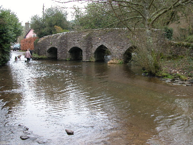
image_caption = Bridge and ford in the village of Bury
etymology =
country = England
country1 =
state = Somerset
state_type = County
state1 =
region =
region1 =
district =
district1 =
city =
city1 =
landmark =
landmark1 =
length_imperial =
watershed_imperial =
discharge_location =
discharge_imperial =
discharge_max_imperial =
discharge_min_imperial =
discharge1_location =
discharge1_imperial =
source_name = Wimbleball Lake
source_location =
source_district =
source_region =
source_state = Somerset
source_country = England
source_lat_d = 51
source_lat_m = 04
source_lat_s = 25
source_lat_NS = N
source_long_d = 3
source_long_m = 27
source_long_s = 57
source_long_EW = W
source_elevation_imperial =
source_length_imperial =
mouth_name = River Exe
mouth_location =
mouth_district =
mouth_region =
mouth_state = Somerset
mouth_country = England
mouth_lat_d = 51
mouth_lat_m = 01
mouth_lat_s = 43
mouth_lat_NS = N
mouth_long_d = 3
mouth_long_m = 31
mouth_long_s = 07
mouth_long_EW = W
mouth_elevation_imperial =
tributary_left =
tributary_left1 =
tributary_right =
tributary_right1 =
free_name =
free_value =


map_size =
map_caption =

The River Haddeo on Exmoor in Somerset flows from the Wimbleball Lake to the River Exe.

The valley of the river consists of three tributary valleys extending down from the surrounding farmland to merge with the River Haddeo in the south. The tributary valleys include the River Pulham, which passes the village of Brompton Regis andcontinues to Hartford where it joins the Haddeo. [cite web |url=http://www.exmoor-nationalpark.gov.uk/lca-g._incised_wooded_valleys.pdf |title=Incised Wooded Valleys |accessdate=2007-11-24 |format=PDF |work=Exmoor National Park ]

In 2001 - 2002 South West Water commissioned a detailed assessment of fish population, physical habitat, flow and water quality data within the River Haddeo, since it has been subject to regulated releases from Wimbleball Reservoir, to identify potential bottlenecks restricting the development of juvenile salmon populations. [cite web |url=http://www.apemltd.co.uk/aquatics/what-we-do/project.php?id=41 |title=Habitat and Flow Improvements to benefit Atlantic Salmon in the River Haddeo |accessdate=2007-11-24 |format= |work=APEM Aquatic Scientists ]

References


Wikimedia Foundation. 2010.

Игры ⚽ Поможем написать реферат

Look at other dictionaries:

  • River Exe — Geobox River name = River Exe native name = other name = other name1 = image size = image caption = The Exe Estuary from a balloon over Exeter. The M5 motorway is in the foreground, Topsham on the left bank just beyond, and Exmouth at the river… …   Wikipedia

  • Mells River — Coordinates: 51°14′50″N 2°19′14″W / 51.24722°N 2.32056°W / 51.24722; 2.32056 …   Wikipedia

  • Wimbleball Lake — Infobox lake lake name = Wimbleball Lake image lake = Wimbleballdam.jpg caption lake = The Dam image bathymetry = caption bathymetry = location = Somerset coords = coord|51|04|N|3|28|W|region:GB type:waterbody source:GNS… …   Wikipedia

  • List of rivers of England — This is a list of rivers of England, organised geographically and taken anti clockwise, from Land s End. It includes the whole length of those rivers whose estuary lies wholly or partly in England and thus includes a number of tributaries which… …   Wikipedia

  • Geology of Somerset — Somerset is a rural county in the southwest of England, covering convert|4171|km2|sqmi|0. It is bounded on the north west by the Bristol Channel, on the north by Bristol and Gloucestershire, on the north east by Wiltshire, on the south east by… …   Wikipedia

  • Exmoor — Geobox|Protected Area name = Exmoor native name = other name = other name1 = category local = National Park of England category iucn = II image size = image caption = View of the Porlock Vale over toward Bossington Hill from Porlock Hill country …   Wikipedia

  • Brendon Hills — Infobox Mountain Name = Brendon Hills Photo = Caption = Elevation = convert|1388|ft|m|0|lk=on Location = Somerset, England Range = Prominence = Parent peak = Coordinates = coord|51|07|26|N|3|30|04|W|display=inline,title Topographic Type =… …   Wikipedia

  • Oare Water — Coordinates: 51°13′05″N 3°43′42″W / 51.21806°N 3.72833°W / 51.21806; 3.72833 …   Wikipedia

  • Liste des cours d'eau d'Angleterre — Cet article présente une liste des cours d eau d Angleterre, classés par position géographique dans le sens inverse des aiguilles d une montre. Ils passent par l Angleterre et se jettent dans les mers qui bordent le pays. Pour l Esk, la Tweed, la …   Wikipédia en Français

  • South West Coast Path — The starting point at Minehead Length 630 miles (1,014 km) Location England: Somerset, Devon, Cornwall …   Wikipedia

Share the article and excerpts

Direct link
Do a right-click on the link above
and select “Copy Link”