- Mells River
-
Mells River River 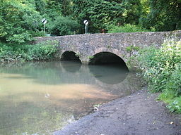 Bridge over the Mells River at Great Elm
Country England County Somerset Tributaries - right Finger Stream, Whatley Brook, Nunney Brook Cities Gurney Slade, Mells, Great Elm, Frome Source - elevation 2 m (7 ft) - length 31 m (102 ft) Secondary source 27 Mouth River Frome - location Frome, Somerset, England - coordinates 51°14′50″N 2°19′14″W / 51.24722°N 2.32056°W The Mells River flows through the eastern Mendip Hills in Somerset, England. It rises at Gurney Slade and flows east joining the River Frome at Frome.
The river forms one of the boundaries of Mells Manor a country house estate in Mells.[1]
Mells River also powered the Old Ironstone Works[2] and several other mills set up by James Fussell in 1744.[3] It is now a 0.25 hectare biological Site of Special Scientific Interest, as it is used by both Greater and Lesser Horseshoe Bats.[4][5]
Vobster Inn Bridge, which carries the lane over the Mells River, is dated 1764, and is Grade II listed.[6] At Great Elm the Murtry Aqueduct[7], built around 1795, carried the Dorset and Somerset Canal over the river.The river takes the outfall from Whatley Quarry.[8] Downstream of the outfall is the Mells River Sink. This acts as a spring when the water table is high and as a sink into underground aquifers, through the Limestone, when the water table is low.[9] Water tracing showed this to be part of an underground part of the river 2.5 kilometres (1.6 mi) long. Archaeological investigations found the remains of woolly rhinoceros bones and a 1st century bronze broach.[10]
References
- ^ "Park, Mells". Somerset Historic Environment Record. Somerset County Council. http://webapp1.somerset.gov.uk/her/details.asp?prn=23827. Retrieved 2009-09-25.
- ^ "The Case for Extending the Mendip Hills Area of Outstanding Natural Beauty". Mendip Hills Society. 2005. http://mendipsociety.org.uk//index.php?option=com_content&task=view&id=42&Itemid=54. Retrieved 2010-10-16.
- ^ Atthill, Robin (1964). Old Mendip. Newton Abbott: David and Charles. ISBN 0715351710.
- ^ "English Nature citation sheet". 2006. http://www.english-nature.org.uk/citation/citation_photo/1000912.pdf. Retrieved 2006-07-25.
- ^ Thornes, Robin (2010). Men of iron. The Fussells of Mells. Frome Society for Local Study. ISBN 9780956586919.
- ^ "Vobster Inn Bridge". Images of England. http://www.imagesofengland.org.uk/details/default.aspx?id=266782. Retrieved 2006-11-14.
- ^ "Murtry Aqueduct". Images of England. English Heritage. http://www.imagesofengland.org.uk/Details/Default.aspx?id=267107. Retrieved 2009-09-25.
- ^ "Quarry control helps maintain river levels". ABB. http://www.abb.co.uk/cawp/seitp202/3A02A8AF404A2014C1256DBF0038329F.aspx. Retrieved 2009-09-25.
- ^ "Mells and the Wadbury Valley". British Geological Survey. http://www.bgs.ac.uk/mendips/localities/mells.html. Retrieved 2009-09-25.
- ^ Stanton, W.I. (1982). "Mells River Sink: A spelaeological curiosity in east mendip Somerset". Proceedings of the Bristol University Spelaeological Society 16 (2): 93–104. http://www.ubss.org.uk/resources/proceedings/vol16/UBSS_Proc_16_2_93-104.pdf.
Categories:- Rivers of Somerset

Wikimedia Foundation. 2010.